
Ponds and waterside areas
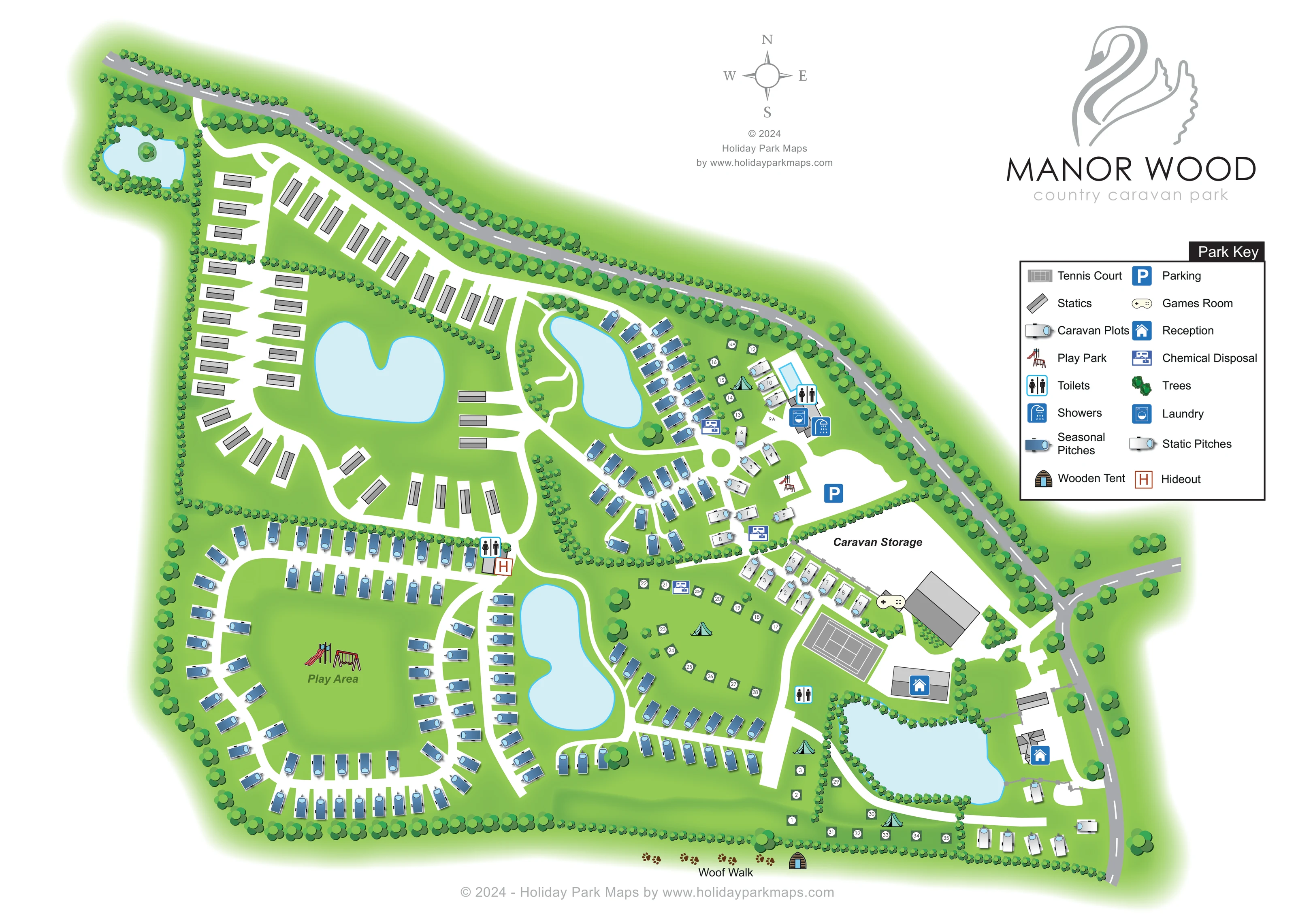
Several irregular pale-blue ponds structure the plan, including a small north-western pond with an island, larger western and central ponds, and a tree-lined pond near reception.
ILLUSTRATED PARK MAP · P209
Coddington, Chester · United Kingdom
 Enlarge the map ↗
A SENSE OF THE PLACE
Manor Wood Country Caravan Park is a small family-run site at Coddington near Chester. Its countryside setting provides views across the Cheshire Plain towards the Welsh hills.
The map shows the layout of the caravan park and its shared areas. It gives touring visitors an overview before a stay in this part of Cheshire, with the surrounding countryside forming the backdrop to their visit.
LOOK CLOSER
Several irregular pale-blue ponds structure the plan, including a small north-western pond with an island, larger western and central ponds, and a tree-lined pond near reception.
Continuous tree belts edge much of the park and divide accommodation areas, roads and water features.
Blue house symbols identify two reception-marked buildings in the eastern arrival area, one near the tennis court and another beside the access lane.
A blue P identifies a broad parking area in the north-eastern accommodation section.
A substantial area labelled Caravan Storage lies between the eastern road boundary, the smaller caravan rows and the games-room building.
A grey court with white playing lines sits beside the games room and reception area.
A game-controller symbol identifies the large grey building immediately north-east of the tennis court.
Play equipment is illustrated in the centre of the large south-western pitch loop and beside the north-eastern parking area.
Blue house symbols identify two reception-marked buildings in the eastern arrival area, one near the tennis court and another beside the access lane.
A blue P identifies a broad parking area in the north-eastern accommodation section.
A substantial area labelled Caravan Storage lies between the eastern road boundary, the smaller caravan rows and the games-room building.
A grey court with white playing lines sits beside the games room and reception area.
A game-controller symbol identifies the large grey building immediately north-east of the tennis court.
Play equipment is illustrated in the centre of the large south-western pitch loop and beside the north-eastern parking area.
Repeated toilet symbols identify facilities in the north-eastern service cluster, beside the western seasonal pitches and near the tennis court.
Shower and washing-machine symbols are grouped with toilets at the north-eastern service buildings.
Purple disposal symbols appear at several locations serving the eastern pitch groups.
An orange outlined H marks a feature called Hideout beside the toilet building between the western seasonal area and a central pond; its function is not further explained.
The southern boundary is labelled Woof Walk and marked with a sequence of paw prints.
Several irregular pale-blue ponds structure the plan, including a small north-western pond with an island, larger western and central ponds, and a tree-lined pond near reception.
Continuous tree belts edge much of the park and divide accommodation areas, roads and water features.
Connections from the eastern boundary road lead to the reception area and an interconnected network of white loops and branching lanes.
The park is at Coddington near Chester, with countryside views across the Cheshire Plain towards the Welsh hills.
READING THE MAP
This illustrated map of Manor Wood Country Caravan Park brings together a pond-rich countryside layout and a varied mix of caravan and camping areas. Located at Coddington near Chester, the park is presented as a series of distinct spaces linked by white internal lanes, with tree belts defining the boundaries and separating neighbouring sections.
Grey static caravans occupy much of the western side, while blue seasonal-pitch symbols follow broad loops and waterside rows across the centre and south. Smaller caravan groups and numbered grass pitches sit nearer the eastern arrival area. Several pale-blue ponds give the plan its distinctive shape and help visitors recognise different parts of the park.
The map also places everyday facilities within that wider layout: reception, parking, toilets, showers, laundry and chemical disposal points appear alongside a tennis court, games room and play areas. A labelled caravan storage area and the paw-print Woof Walk add useful site-specific detail. Large Manor Wood branding and a compact pictorial key complete a design intended to explain both the accommodation layout and the shared spaces around it.
The single landscape-format artwork combines an overhead park plan with a large branding and legend area on the right. A grey road follows the northern edge before curving down the eastern boundary, where access lanes connect to reception-marked buildings and the main shared facilities. Inside the park, white routes form a network of loops, spurs and short pitch approaches.
The western accommodation area is drawn with elongated grey static-caravan symbols. Its lanes wrap around a broad, irregular pond, while a smaller pond with a planted island sits near the north-western corner. Further south, a large loop of blue seasonal-caravan symbols encloses an open green centre containing illustrated play equipment. Additional blue-caravan rows follow the central ponds and the southern side of the park.
The eastern half has smaller white-caravan groups and open grass areas with numbered pitch markers and occasional tent drawings. Near the north-eastern service cluster, icons identify toilets, showers and laundry. Other toilet and chemical-disposal symbols are distributed through the plan. An orange H marks the named Hideout beside the western service building. A small blue-outlined rectangle near the north-eastern facilities is not labelled with a function.
Close to the eastern entrance, the tennis court is recognisable by its white court lines. A controller icon marks the neighbouring games room, and Caravan Storage is directly labelled on the large area above it. Reception symbols appear on buildings near the court and the boundary access lane. Along the southern edge, paw prints identify Woof Walk, with a wooden tent illustration nearby.
Repeated tree canopies, pale-blue water and a soft green perimeter fade unify the drawing. The supplied detail view enlarges the same artwork’s key and eastern facilities; it is not a separate map variant.
KEEP EXPLORING
Chosen for shared landscapes, accommodation or facilities.
 Explore the map ↗
United Kingdom
Woodland-framed Barnsoul map with mixed accommodation, shared facilities and paw-marked walking routes.
 Explore the map ↗
United Kingdom
A colour-zoned coastal park map with touring areas, woodland trails, ponds and a leisure club.
 Explore the map ↗
United Kingdom
Woodland holiday-park map with named accommodation areas, touring loops and illustrated recreation facilities.
Features may come from the sample artwork, its key or published park information. Approximate numbers describe the drawing and may cover only part of a park. They are intended to help you compare map examples. Current facilities and booking information should be checked with the park.
TAKE A CLOSER LOOK
View the illustrated map in detail or choose a file to download. These are sample maps; contact the park for current visitor information.


LET’S MAP YOUR PARK
For a map quotation, find your park and draw a rough boundary around it. The area you select helps us work out the design time and price.
Draw your park for a quote ↗Or talk to our map designers
01751 473136