
Woodland and planted boundaries
Dense trees frame the eastern and southern perimeter, with hedges and smaller tree groups dividing accommodation areas.
ILLUSTRATED PARK MAP · P496
HETHERICK CARAVAN PARK, Near Kinninvie, Barnard Castle, County Durham · United Kingdom
 Enlarge the map ↗
A SENSE OF THE PLACE
Hetherick Caravan Park is a family-owned site near Barnard Castle in Teesdale. It offers touring and seasonal caravan pitches, tent camping, static caravans and lodge accommodation.
Woodland, planting and small streams shape the grounds. Washrooms, showers, laundry, a children's play area and a dog exercise area provide on-site facilities, while the wider Teesdale countryside offers walking and sightseeing opportunities.
LOOK CLOSER
Dense trees frame the eastern and southern perimeter, with hedges and smaller tree groups dividing accommodation areas.
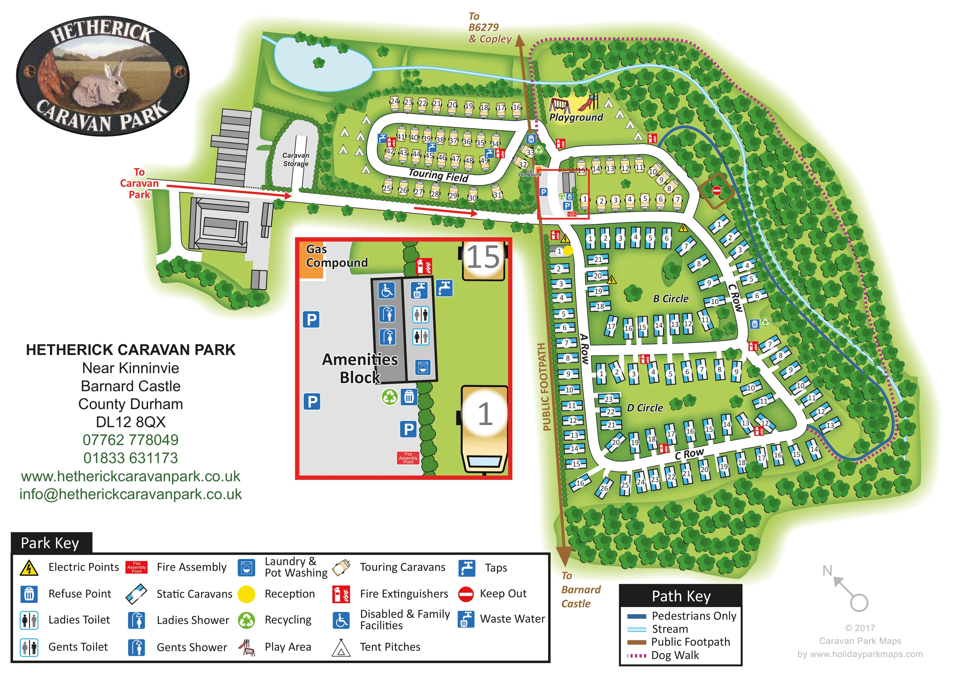
A cyan stream crosses the upper edge of the site and curves through the wooded eastern boundary.
An unlabelled pale-blue oval water feature is drawn at the upper left, connected visually to the stream.
A yellow reception marker appears beside the top of A Row, close to the amenities and arrival junction.
A central service building is shown on the main plan and in a large red-bordered enlargement.
Ladies' and gents' toilet and shower symbols are positioned within the amenities inset.
The amenities inset includes the wheelchair symbol identified in the key as Disabled & Family Facilities.
A blue laundry symbol in the amenities block corresponds to the combined Laundry & Pot Washing key entry.
A yellow reception marker appears beside the top of A Row, close to the amenities and arrival junction.
A central service building is shown on the main plan and in a large red-bordered enlargement.
Ladies' and gents' toilet and shower symbols are positioned within the amenities inset.
The amenities inset includes the wheelchair symbol identified in the key as Disabled & Family Facilities.
A blue laundry symbol in the amenities block corresponds to the combined Laundry & Pot Washing key entry.
Blue P symbols mark parking around the amenities forecourt, clearly visible in the enlargement.
Tap symbols appear within the touring area and beside the amenities block.
A waste-water symbol is shown at the upper edge of the touring loop near the playground junction.
Blue refuse and green recycling symbols are grouped near the amenities and at further points around the park.
Yellow lightning-triangle symbols mark electric points within the caravan areas.
Red extinguisher symbols recur beside accommodation roads; the fire assembly point is shown at the amenities forecourt.
A labelled playground with illustrated swings and a slide occupies the wooded upper part of the plan.
An orange-labelled compound sits beside the amenities area and is enlarged in the inset.
A separate storage area lies beside the approach road, west of the Touring Field.
Dense trees frame the eastern and southern perimeter, with hedges and smaller tree groups dividing accommodation areas.
A cyan stream crosses the upper edge of the site and curves through the wooded eastern boundary.
An unlabelled pale-blue oval water feature is drawn at the upper left, connected visually to the stream.
A magenta dotted route follows the wooded northern and eastern perimeter.
A brown route runs along the western edge of the main accommodation area, with arrows towards the B6279 and Copley, and towards Barnard Castle.
Short dark-blue connections between caravan plots are explained by the Pedestrians Only entry in the path key.
Red directional arrows highlight the approach from the left; white internal roads connect the touring loop, amenities junction and static caravan areas.
A red no-entry symbol marks a small outlined area beside the wooded eastern edge, above C Row.
READING THE MAP
This illustrated map presents Hetherick Caravan Park near Kinninvie, Barnard Castle, as a wooded site with clearly separated touring and static caravan areas. The touring pitches occupy a compact loop towards the upper left, while the larger static caravan section is organised into named circles and rows on the right. A stream, dense tree belts and a dotted woodland dog walk give the plan a strong sense of its countryside setting.
The artwork combines a whole-site overview with a prominent enlargement of the amenities block. This makes the toilets, showers, laundry and pot-washing facilities easier to locate without crowding the main plan. The playground, caravan storage, reception marker and service points are also shown, alongside tent-pitch areas on open grass.
For visitors, the map brings together numbered accommodation, arrival arrows and several different route types. For a mapping client, it demonstrates how a mixed caravan and camping site can retain its landscape character while providing practical directions to pitches, shared facilities and walking routes.
The main plan is arranged around an approach road entering from the left, past a group of buildings and a labelled caravan storage area. Red arrows draw attention to this arrival route, which continues to the central amenities junction. Above it, cream touring caravan symbols follow a rounded road loop and an adjoining curved row. Tent symbols mark grassy areas beside the Touring Field and around the playground.
The larger static caravan area extends down the right-hand side. Blue-and-white units are grouped into A Row, B Circle, C Row and D Circle, with generous green spaces inside the two circles. White roads with black outlines connect these areas, while short blue pedestrian links provide another layer of movement between plots. A yellow reception marker appears near the head of A Row.
The amenities block receives a separate red-bordered enlargement, connected visually to a locator rectangle on the main map. It shows ladies' and gents' toilets and showers, disabled and family facilities, laundry and pot washing, taps, parking, refuse and recycling, a fire assembly point and the neighbouring gas compound. Further service and fire symbols are distributed around the accommodation roads.
Landscape is an important organising element. An unlabelled pond-like feature at the upper left connects to a stream that crosses the northern grounds and curves down the wooded eastern edge. The playground sits among trees near the top of the plan. A magenta dotted dog walk follows the outer woodland, while a brown public footpath runs along the western side with directions towards Barnard Castle and the B6279 and Copley. Separate Park and Path keys explain the symbols and lines. The additional close-up images enlarge these same legends rather than showing separate park sections.
KEEP EXPLORING
Chosen for shared landscapes, accommodation or facilities.
 Explore the map ↗
United Kingdom
A woodland estate park map combining caravan loops, touring pitches, riverside paths and Bruce’s Cave landmarks.
 Explore the map ↗
United Kingdom
Woodland park map with mixed pitches, bell tents, lodges and a fishing lake.
 Explore the map ↗
United Kingdom
Woodland holiday homes, named camping fields and farm buildings on a colour-coded Nether Wasdale park map.
Features may come from the sample artwork, its key or published park information. Approximate numbers describe the drawing and may cover only part of a park. They are intended to help you compare map examples. Current facilities and booking information should be checked with the park.
TAKE A CLOSER LOOK
View the illustrated map in detail or choose a file to download. These are sample maps; contact the park for current visitor information.


LET’S MAP YOUR PARK
For a map quotation, find your park and draw a rough boundary around it. The area you select helps us work out the design time and price.
Draw your park for a quote ↗Or talk to our map designers
01751 473136