
Farm buildings, farm house and yard
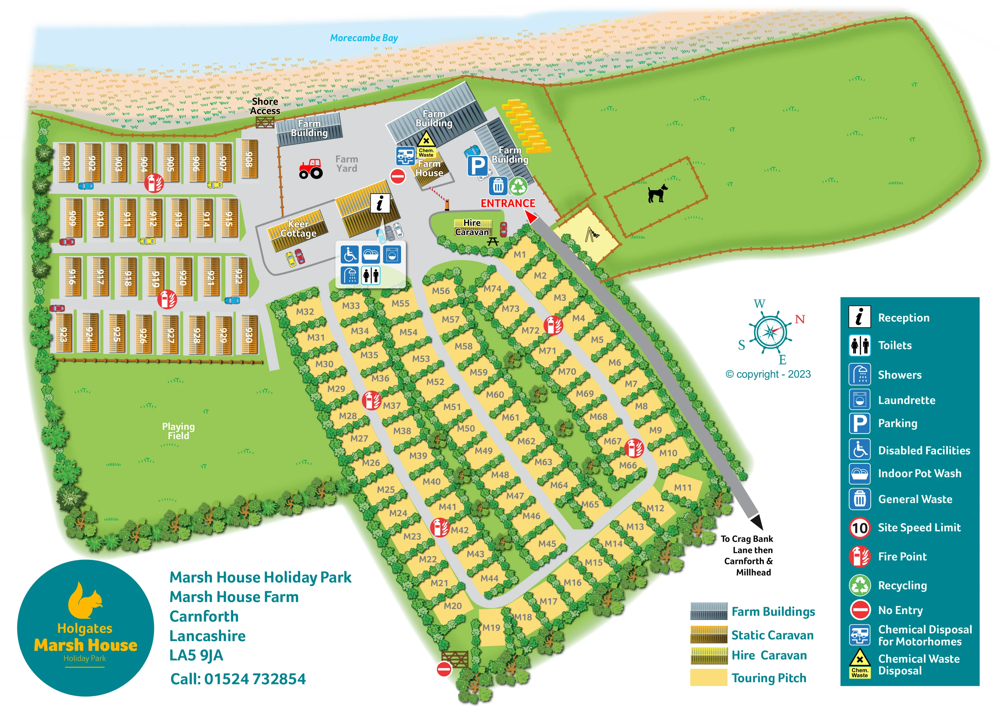
The central farm complex includes labelled buildings, a farm house and a broad yard, illustrated with a tractor and stacked bales.
ILLUSTRATED PARK MAP · P212
Marsh House Farm, Carnforth, Lancashire · United Kingdom
 Enlarge the map ↗
A SENSE OF THE PLACE
Marsh House is a small Holgates park near Carnforth, where the River Keer meets Morecambe Bay. Views across the bay and towards Warton Crag define its coastal setting.
Seasonal touring and static holiday home ownership provide the main ways to use the park. Coastal walking and trips into the surrounding Lancashire and Cumbria countryside complement time on site.
LOOK CLOSER
The central farm complex includes labelled buildings, a farm house and a broad yard, illustrated with a tractor and stacked bales.
A named building beside reception provides a useful landmark; its accommodation use is not specified by the artwork.
The labelled bay runs along the upper edge, with pale-blue water and a broad, textured sandy and grassy shoreline.
Dense planting divides touring pitches and encloses the accommodation areas, contrasting with a large fenced grass field beside the farm.
An information symbol identifies reception in the central building group beside the farm yard and touring area.
A grouped facility callout beside reception locates the toilets, showers, laundrette and indoor washing-up facilities.
A wheelchair symbol appears in the central amenity callout; the map does not specify the facilities' detailed accessibility characteristics.
A parking symbol is placed beside the farm buildings near the entrance; illustrated cars also help distinguish arrival and building-side spaces.
An information symbol identifies reception in the central building group beside the farm yard and touring area.
A grouped facility callout beside reception locates the toilets, showers, laundrette and indoor washing-up facilities.
A wheelchair symbol appears in the central amenity callout; the map does not specify the facilities' detailed accessibility characteristics.
A parking symbol is placed beside the farm buildings near the entrance; illustrated cars also help distinguish arrival and building-side spaces.
Adjacent waste and recycling symbols mark a collection point in the entrance and farm-building area.
Separate chemical waste and motorhome disposal symbols appear beside the farm house and yard.
Repeated red fire-point symbols are distributed through both accommodation areas.
A large labelled grass playing field occupies the space below the static caravan rows, edged by trees and shrubs.
A swing illustration marks a small fenced, pale-yellow play area beside the entrance road.
A black dog silhouette identifies a small fenced grass enclosure within the larger field beside the entrance. No usage rules are stated.
A picnic-table symbol is drawn beside the hire caravan near the entrance.
The central farm complex includes labelled buildings, a farm house and a broad yard, illustrated with a tractor and stacked bales.
A named building beside reception provides a useful landmark; its accommodation use is not specified by the artwork.
The labelled bay runs along the upper edge, with pale-blue water and a broad, textured sandy and grassy shoreline.
Dense planting divides touring pitches and encloses the accommodation areas, contrasting with a large fenced grass field beside the farm.
A red arrow and prominent ENTRANCE label mark arrival beside the farm complex; an illustrated barrier appears within the arrival area.
The outgoing road is labelled towards Crag Bank Lane, then Carnforth and Millhead.
A labelled gate beside a farm building leads to the shore-edge route above the static caravans.
Grey roads connect the arrival area to straight caravan lanes and elongated touring loops, including curved links around the lower end.
Red no-entry symbols identify a farm-yard approach and a gated boundary at the lower end of the touring area.
The legend includes a red-ringed 10 symbol labelled Site Speed Limit; a corresponding location is not clearly shown on the plan.
READING THE MAP
This illustrated map of Marsh House Holiday Park brings together a coastal Lancashire setting, a working-farm backdrop and two clearly different accommodation layouts. Morecambe Bay stretches across the top of the artwork, with a textured shoreline and a labelled shore-access gate establishing the park's relationship with the coast.
The plan places the farm buildings, reception and shared facilities at the centre of the visitor experience. To one side, static caravans sit in neat parallel rows; below and to the right, touring pitches follow longer roads and loops, each plot framed by illustrated hedges. A separate hire caravan is picked out close to the entrance. Open grassland, a playing field and small pictorial recreation areas prevent the map from reading simply as a collection of numbered pitches.
Teal Holgates branding, yellow accommodation colours and large facility symbols tie the page together. The result is a useful sample for parks that need an arrival and pitch-finding map while also showing the landscape, landmarks and outdoor spaces that give their site its character.
The single landscape-format plan is organised around the farm and reception buildings near the upper centre. An approach road enters from the lower right, with an arrow directing visitors towards Crag Bank Lane, Carnforth and Millhead. At the arrival point, red entrance lettering stands out beside parking, general waste and recycling symbols. Chemical waste and motorhome disposal points are marked closer to the farm house and yard.
The accommodation is divided into two visually distinct areas. On the left, gold-roofed static caravans occupy four straight rows, served by grey lanes and bordered by planting. The larger touring section extends down the page in a tapering shape. Pale-yellow pitches sit between repeated hedge motifs, while elongated roads connect through curved lower links. Plot labels make the individual spaces identifiable without relying on drawn caravans. A brighter yellow hire caravan occupies its own small landscaped space near the entrance, accompanied by a picnic-table symbol.
Reception is marked with an information icon. A nearby grouped callout identifies toilets, showers, a laundrette, indoor pot wash and disabled facilities. Red fire-point symbols recur through the accommodation areas. Keer Cottage, the farm house and several farm buildings provide named landmarks, with a tractor and bales adding recognisable farm detail.
Beyond the pitches, the map shows a large playing field, a small swing area and a fenced enclosure marked by a dog silhouette. Morecambe Bay, shoreline vegetation and a gated shore access establish the coastal edge. The right-hand teal legend, separate accommodation key, nautical compass and lower-left Holgates branding complete the composition. The enlarged views show overlapping portions of this same artwork, not additional park sections.
KEEP EXPLORING
Chosen for shared landscapes, accommodation or facilities.
 Explore the map ↗
United Kingdom
A colour-zoned coastal park map with touring areas, woodland trails, ponds and a leisure club.
 Explore the map ↗
United Kingdom
Tree-framed mixed-accommodation park map with two entrances, touring loops and a clearly illustrated social hub.
 Explore the map ↗
United Kingdom
Colour-coded holiday homes, numbered pitch fields and a prominent pool complex on Hendra's whole-park plan.
Features may come from the sample artwork, its key or published park information. Approximate numbers describe the drawing and may cover only part of a park. They are intended to help you compare map examples. Current facilities and booking information should be checked with the park.
LET’S MAP YOUR PARK
For a map quotation, find your park and draw a rough boundary around it. The area you select helps us work out the design time and price.
Draw your park for a quote ↗Or talk to our map designers
01751 473136