
Dog walking field
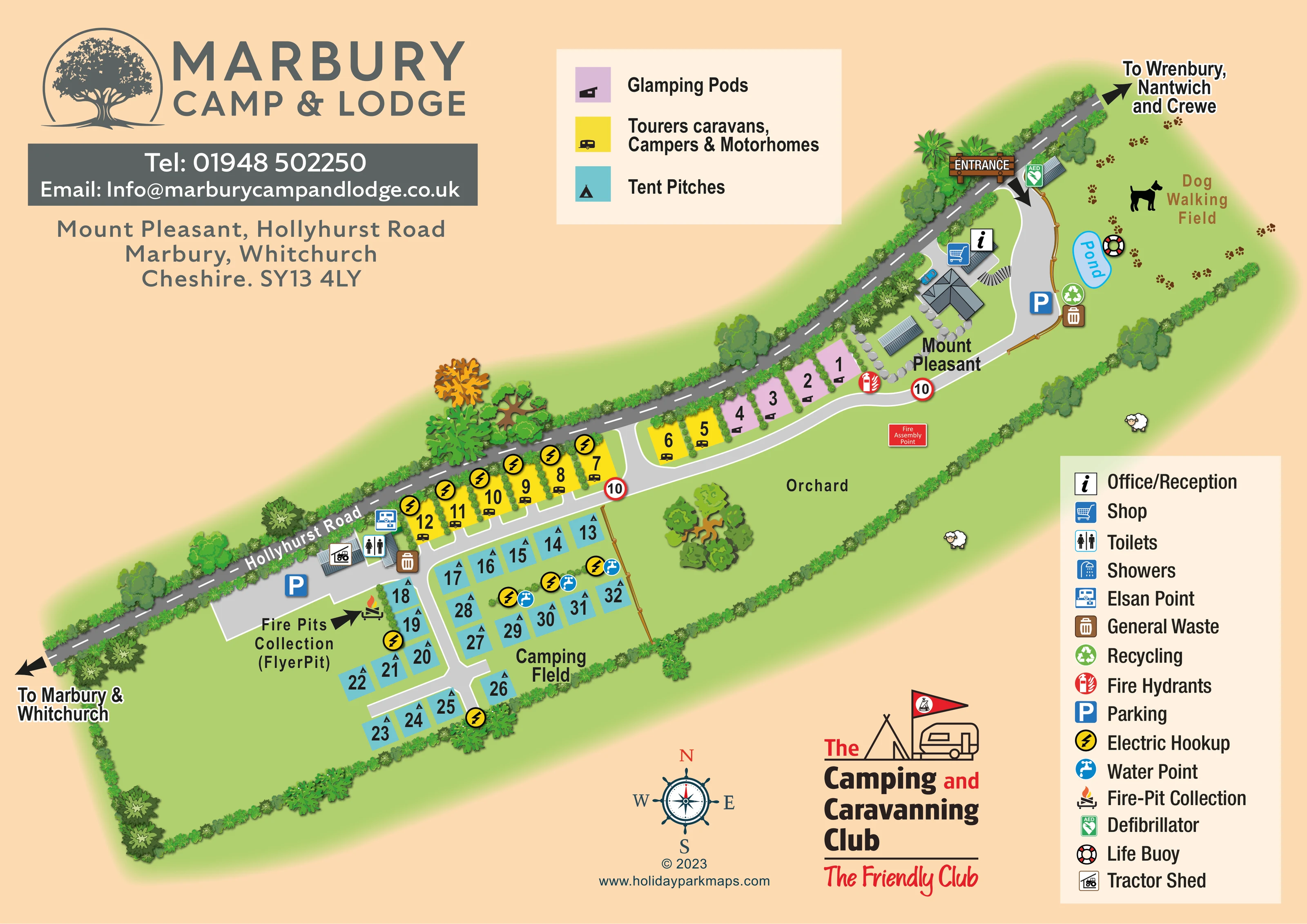
A separate field at the entrance end is labelled for dog walking and illustrated with a dog silhouette and scattered paw prints.
ILLUSTRATED PARK MAP · P211
Mount Pleasant, Hollyhurst Road, Marbury, Whitchurch, Cheshire · United Kingdom
 Enlarge the map ↗
A SENSE OF THE PLACE
Marbury Camp and Lodge is a family-run countryside site near Whitchurch. Its meadow setting offers a quieter base for camping and outings around the Cheshire border area.
Published visitor information describes bicycle hire, a fenced dog area and barbecue equipment hire. Nearby towns and attractions provide options for excursions, while the map explains the arrangement of accommodation and shared areas on site.
LOOK CLOSER
A separate field at the entrance end is labelled for dog walking and illustrated with a dog silhouette and scattered paw prints.
A small blue pond is labelled within the dog-walking field beside the entrance-side lane.
A broad green area alongside the accommodation is labelled Orchard and illustrated with a prominent spreading tree.
Continuous illustrated hedges define the roadside and field boundaries, with varied trees and short planted divisions between roadside pitches.
An information symbol identifies reception within the Mount Pleasant building cluster near the entrance.
A shopping-trolley symbol marks the shop beside reception.
Toilets are marked in the western service-building cluster beside the touring pitches and parking area.
A chemical-waste disposal symbol appears beside the western toilet and service buildings.
An information symbol identifies reception within the Mount Pleasant building cluster near the entrance.
A shopping-trolley symbol marks the shop beside reception.
Toilets are marked in the western service-building cluster beside the touring pitches and parking area.
Showers appear in the facilities key, but a separate shower marker is not clearly identifiable on the plan.
A chemical-waste disposal symbol appears beside the western toilet and service buildings.
General-waste markers appear at the entrance-side parking area and western service cluster; recycling is marked near the pond.
Blue parking symbols identify an entrance-side area beside Mount Pleasant and a larger grey area near the camping services.
Yellow lightning symbols mark hookups along the touring row and at selected positions within the tent-pitch area.
Several blue tap symbols are grouped among the camping pitches.
An arrow and flame illustration mark the fire-pit collection point beside the western parking area, with the parenthetical label 'FlyerPit'.
A green AED marker is placed on a small building immediately inside the entrance.
A red firefighting marker beside the pod row is identified as a fire hydrant by the legend.
A red labelled assembly-point sign appears in the orchard-side open space below the main internal lane.
A life-buoy symbol is positioned beside the pond.
A tractor-shed symbol identifies a building in the western service cluster.
A separate field at the entrance end is labelled for dog walking and illustrated with a dog silhouette and scattered paw prints.
A small blue pond is labelled within the dog-walking field beside the entrance-side lane.
A broad green area alongside the accommodation is labelled Orchard and illustrated with a prominent spreading tree.
Continuous illustrated hedges define the roadside and field boundaries, with varied trees and short planted divisions between roadside pitches.
The named building cluster near reception forms the principal built landmark at the arrival end of the site.
A signed entrance from Hollyhurst Road feeds a curving grey lane past Mount Pleasant, the pods and touring pitches, then branches through the camping area.
The diagonal public road is labelled, with arrows towards Marbury and Whitchurch at one end and Wrenbury, Nantwich and Crewe at the other.
Red-ringed '10' signs punctuate the principal internal lane.
READING THE MAP
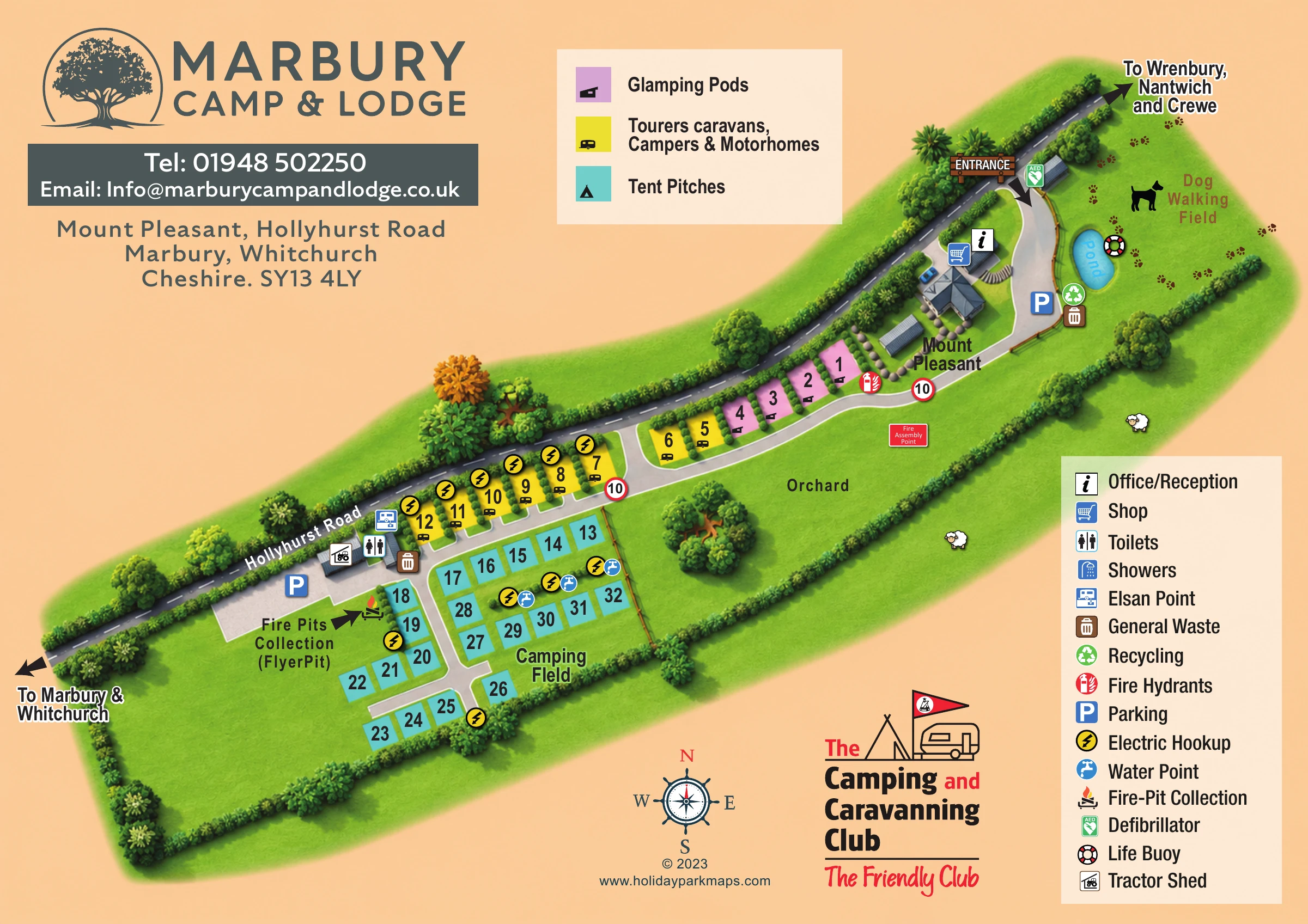
This illustrated map of Marbury Camp & Lodge presents a small countryside camping and glamping site at Mount Pleasant, near Marbury and Whitchurch in Cheshire. The layout follows Hollyhurst Road diagonally across the page, with a clearly marked entrance at one end and directional arrows linking the site to surrounding towns. A warm peach background and leafy green boundaries give the plan a rural character without obscuring its practical information.
Three accommodation colours distinguish glamping pods, touring pitches for caravans and motorhomes, and tent pitches in the camping field. The map shows roughly 30 accommodation positions overall, arranged around a main internal lane and short branches. Reception and the shop sit near the arrival area, while toilets, an Elsan point and fire-pit collection are grouped further along the site.
The orchard, pond and separate dog-walking field are important parts of the composition rather than incidental decoration. Together with the numbered pitches, parking symbols and two clear legend panels, they make this a useful example of a compact site map that balances arrival guidance, pitch finding and countryside identity.
The plan is organised around the diagonal line of Hollyhurst Road, shown as a dark grey carriageway with dashed white markings. At the upper-right end, a timber-style entrance sign and bold arrow lead into a pale grey internal lane. This curves past the Mount Pleasant building cluster, where reception and shop symbols establish the arrival hub. Parking, waste and recycling markers sit nearby, with a defibrillator marked close to the entrance.
The accommodation follows a clear progression. A short lilac row identifies glamping pods beside Mount Pleasant, followed by yellow touring plots along the roadside hedge. The turquoise tent pitches occupy the Camping Field at the opposite end, grouped around branching lanes rather than spread across an undifferentiated meadow. Large numbers and small accommodation pictograms make the plot blocks easy to distinguish. Hookup markers appear along the touring row and within parts of the camping area, while blue water-point symbols serve the tent-pitch groups.
The western service area contains parking, toilets, an Elsan point and a tractor shed. An arrow draws attention to fire-pit collection beside this cluster. The facilities legend also includes showers. Elsewhere, the map marks a fire assembly point in the orchard-side open space, a firefighting point near the pods and a life buoy beside the labelled pond.
Landscape illustrations give each area a recognisable character: varied trees line the road, hedges frame the site, a spreading tree anchors the orchard, and paw prints animate the dog-walking field. Two cream legend panels, prominent park branding, a compass rose and a Camping and Caravanning Club graphic complete the single-page composition.
 Enlarge this map ↗
KEEP EXPLORING
Chosen for shared landscapes, accommodation or facilities.
 Explore the map ↗
United Kingdom
Colour-coded accommodation, woodland ponds and a Tarka Trail footpath on Smytham’s illustrated park map.
 Explore the map ↗
United Kingdom
Woodland-framed Barnsoul map with mixed accommodation, shared facilities and paw-marked walking routes.
 Explore the map ↗
United Kingdom
Woodland holiday-park map with named accommodation areas, touring loops and illustrated recreation facilities.
Features may come from the sample artwork, its key or published park information. Approximate numbers describe the drawing and may cover only part of a park. They are intended to help you compare map examples. Current facilities and booking information should be checked with the park.
LET’S MAP YOUR PARK
For a map quotation, find your park and draw a rough boundary around it. The area you select helps us work out the design time and price.
Draw your park for a quote ↗Or talk to our map designers
01751 473136