
Recreation ground
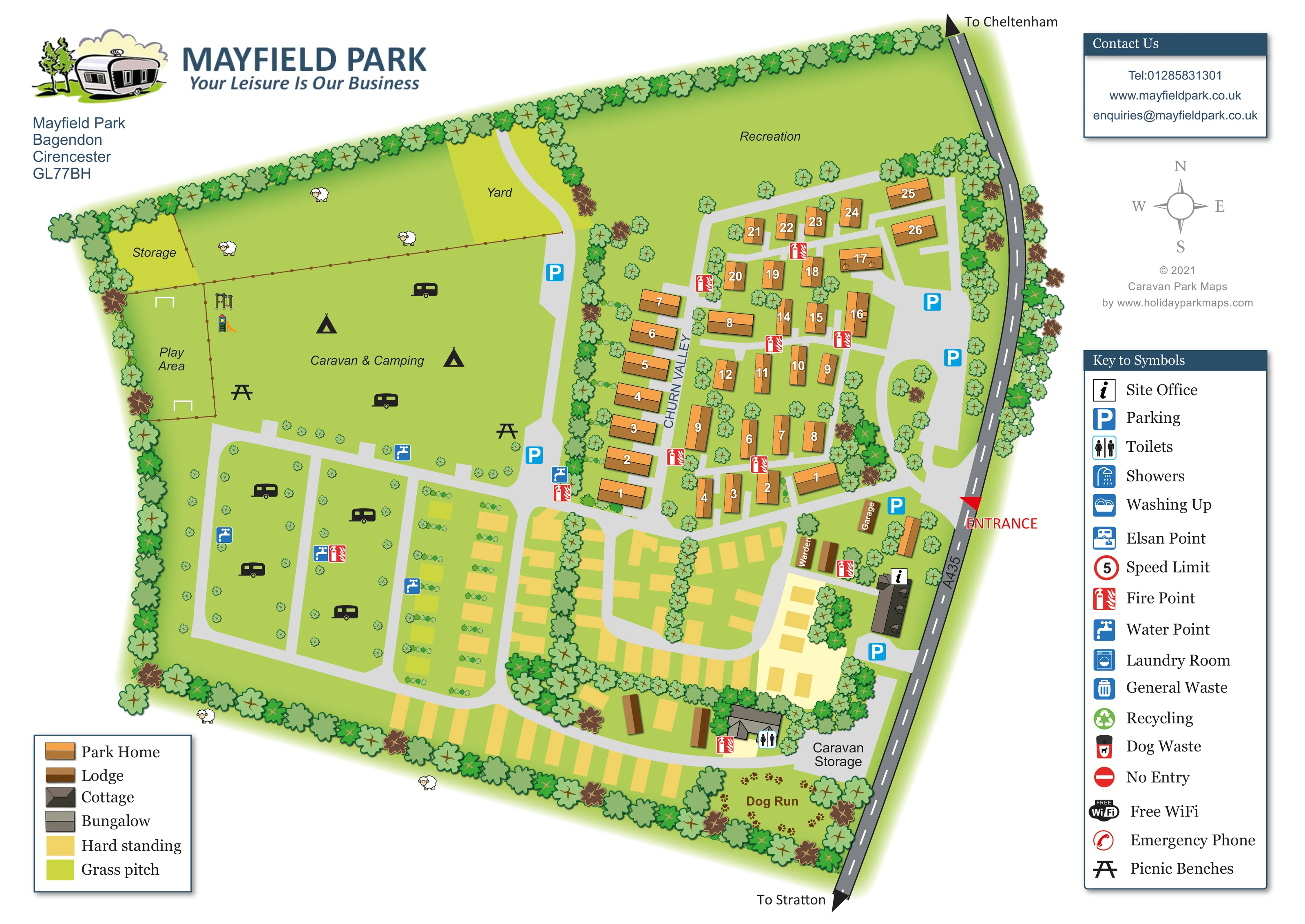
A large, unbuilt green area labelled 'Recreation' extends across the northern side.
ILLUSTRATED PARK MAP · P537
Mayfield Park, Bagendon, Cirencester · United Kingdom
 Enlarge the map ↗
A SENSE OF THE PLACE
Mayfield Park is a family-run camping, caravan and residential park near Cirencester. Its sloping grounds overlook the Churn Valley in the Cotswolds.
Touring, camping and seasonal pitches are offered alongside the park's residential use. The location provides access to Cirencester and countryside outings, while the map helps distinguish the different areas and shared facilities within the site.
LOOK CLOSER
A large, unbuilt green area labelled 'Recreation' extends across the northern side.
Dense illustrated trees enclose the site, divide its principal uses and form islands among the park homes.
An information symbol identifies the office building just inside the roadside entrance.
Blue parking symbols appear around the entrance, home area and central access road.
A toilet symbol marks the southern building beside the touring pitches and caravan storage.
Repeated blue water symbols serve the touring and camping areas; red fire-point symbols are distributed across the pitch areas and park-home clusters.
A fenced western play area is illustrated with play equipment and small goal frames.
Black picnic-table symbols are placed in the open caravan and camping area.
An information symbol identifies the office building just inside the roadside entrance.
Blue parking symbols appear around the entrance, home area and central access road.
A toilet symbol marks the southern building beside the touring pitches and caravan storage.
Repeated blue water symbols serve the touring and camping areas; red fire-point symbols are distributed across the pitch areas and park-home clusters.
A fenced western play area is illustrated with play equipment and small goal frames.
Black picnic-table symbols are placed in the open caravan and camping area.
A separate dog run occupies the south-eastern corner, with paw-print decoration.
Caravan storage is labelled near the southern boundary; a second area labelled 'Storage' lies at the north-western edge.
Buildings labelled 'Warden' and 'Garage' provide landmarks near the entrance.
A large, unbuilt green area labelled 'Recreation' extends across the northern side.
A yard lies beside the northern end of the main internal access road.
Dense illustrated trees enclose the site, divide its principal uses and form islands among the park homes.
The park's sloping grounds overlook the Churn Valley. 'CHURN VALLEY' also appears as a label through the home area, but the artwork does not explicitly depict a valley panorama.
A red entrance arrow connects the park to the A435 on the eastern edge, with directions to Cheltenham and Stratton at opposite ends of the road.
Light-grey roads branch from the entrance into the home clusters, form loops through the pitches and continue north beside the open camping field.
These facilities have entries in the symbol key, but their individual locations are not clearly marked on the plan.
An Elsan-point symbol is included in the key without a clearly identifiable mapped location.
All three disposal categories are listed in the key; distinct locations are not evident in the artwork.
Both appear in the key without clearly located symbols on the plan.
The legend includes a speed-limit symbol displaying 5 and a no-entry symbol; neither establishes a specific mapped restriction location.
READING THE MAP
This illustrated map of Mayfield Park brings together the different parts of a mixed camping, touring and residential park near Cirencester. Set in Bagendon in the Cotswolds, the park has sloping grounds overlooking the Churn Valley. The artwork presents that varied site as a clear overhead plan, using tree-lined boundaries, coloured pitches and recognisable building shapes to distinguish its principal areas.
The A435 runs down the right-hand edge, with a prominent red entrance marker and directions towards Cheltenham and Stratton. Inside the park, numbered homes occupy the eastern side, while touring pitches and an open caravan and camping field spread across the west and south. Recreation ground, a play area and a separate dog run give the plan useful landmarks beyond accommodation alone.
Two keys support different reading tasks: one explains home, building and pitch categories, while the other sets out visitor-service symbols. Combined with the park's caravan logo, contact panel and compass, the result is a practical example of a branded site map for a park with several distinct uses.
The plan is organised around an entrance from the A435 on the eastern boundary. A red arrow makes this arrival point easy to find, and the nearby office, garage, warden buildings and parking symbols establish the first group of landmarks. Pale-grey internal roads then divide, serving the park-home area to the north-east and the touring and camping areas to the west and south.
Orange, numbered park-home roof shapes sit in compact clusters among small trees and landscaped islands. Their short access spurs contrast with the broader loops and parallel lanes through the pitch areas. Here, yellow rectangles indicate hard standings and yellow-green rectangles indicate grass pitches. The large field labelled 'Caravan & Camping' uses only a few tent and caravan illustrations, communicating its use without suggesting a fixed pitch count.
A fenced play area on the western edge contains illustrated equipment and goal frames. Picnic-table symbols sit in the camping field, while a large recreation area occupies the northern boundary. The southern edge includes a toilet-marked building, caravan storage and a dog run distinguished by paw prints. Water and fire-point symbols are repeated where visitors need to recognise shared service points.
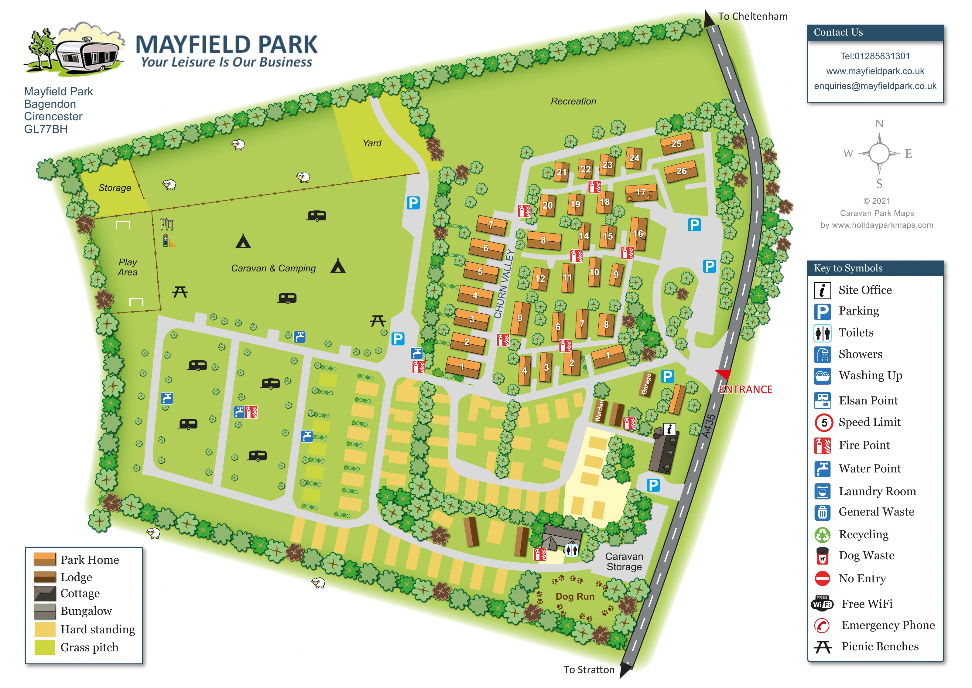
The main artwork is supported by two different keys. The lower-left panel explains accommodation and pitch appearances; the taller right-hand panel lists facility symbols, including some services whose individual positions are not marked on the plan. Navy branding and contact panels balance the green site illustration against a white background. The accompanying enlargement repeats the entrance, dog-run corner and facility key at a more readable scale; it is a detail of this same single-page design.
KEEP EXPLORING
Chosen for shared landscapes, accommodation or facilities.
 Explore the map ↗
United Kingdom
Woodland-framed Barnsoul map with mixed accommodation, shared facilities and paw-marked walking routes.
 Explore the map ↗
United Kingdom
Illustrated touring and camping map with hedge-divided fields, age-labelled play areas and a detailed service key.
 Explore the map ↗
United Kingdom
Woodland park map with mixed pitches, bell tents, lodges and a fishing lake.
Features may come from the sample artwork, its key or published park information. Approximate numbers describe the drawing and may cover only part of a park. They are intended to help you compare map examples. Current facilities and booking information should be checked with the park.
TAKE A CLOSER LOOK
View the illustrated map in detail or choose a file to download. These are sample maps; contact the park for current visitor information.


LET’S MAP YOUR PARK
For a map quotation, find your park and draw a rough boundary around it. The area you select helps us work out the design time and price.
Draw your park for a quote ↗Or talk to our map designers
01751 473136
 mayfieldcaravanparkmap_large.png