
Lawn
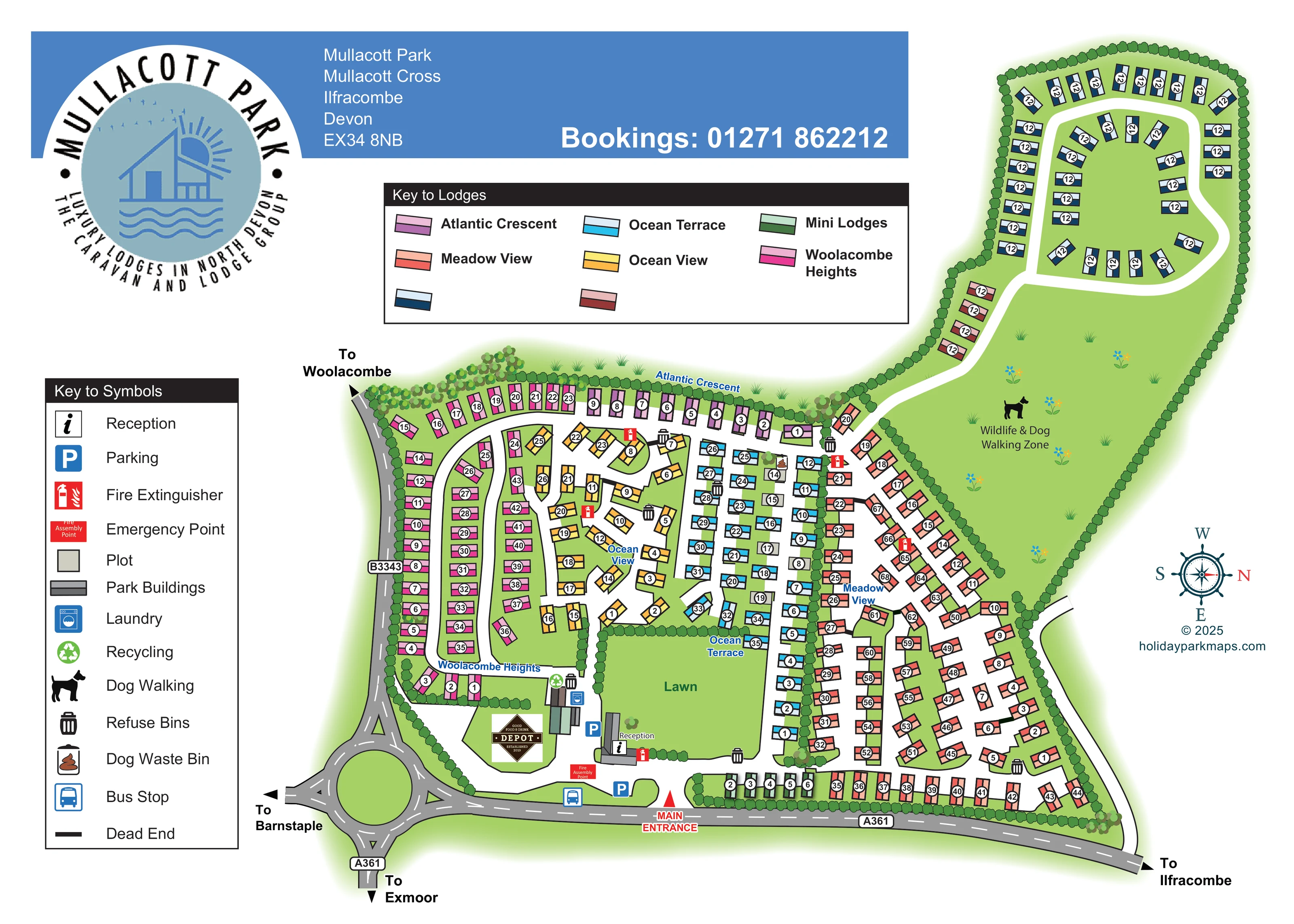
A large rectangular green space separates reception from the central lodge groups and is explicitly labelled Lawn.
ILLUSTRATED PARK MAP · P221
Mullacott Park, Mullacott Cross, Ilfracombe, Devon · United Kingdom
 Enlarge the map ↗
A SENSE OF THE PLACE
Mullacott Park offers holiday lodges between Woolacombe and Ilfracombe in North Devon. Its elevated, sloping grounds give many properties views over meadows or towards the sea.
The location provides access to Woolacombe's beaches, Ilfracombe's harbour and the landscapes of Exmoor. The map helps visitors understand the lodge layout across the hillside and locate the internal roads and shared areas.
LOOK CLOSER
A large rectangular green space separates reception from the central lodge groups and is explicitly labelled Lawn.
An elongated green area occupies the right-hand extension, illustrated with a dog silhouette, flowers and grass tufts.
Continuous scalloped green hedges frame the park and divide several lodge areas, with fuller tree clusters at corners and junctions.
Labelled beside the entrance-side building cluster, immediately below the central lawn.
Blue parking symbols mark spaces near reception and the main entrance.
A laundry symbol appears beside the service buildings at the lower end of Woolacombe Heights.
A separate Depot badge reading 'Good Food & Drink' marks an entrance-side location beside the shared buildings.
Refuse-bin symbols are distributed along accommodation roads; a recycling symbol appears beside the laundry and service-building cluster.
Labelled beside the entrance-side building cluster, immediately below the central lawn.
Blue parking symbols mark spaces near reception and the main entrance.
A laundry symbol appears beside the service buildings at the lower end of Woolacombe Heights.
A separate Depot badge reading 'Good Food & Drink' marks an entrance-side location beside the shared buildings.
Refuse-bin symbols are distributed along accommodation roads; a recycling symbol appears beside the laundry and service-building cluster.
A dog-waste-bin symbol is positioned in the upper part of the central lodge layout.
Red extinguisher symbols occur across the main lodge areas. A fire assembly point is marked near the entrance; the legend describes this symbol as an emergency point.
Grey and muted-green building footprints form a small shared-service cluster near reception and the laundry.
A large rectangular green space separates reception from the central lodge groups and is explicitly labelled Lawn.
An elongated green area occupies the right-hand extension, illustrated with a dog silhouette, flowers and grass tufts.
Continuous scalloped green hedges frame the park and divide several lodge areas, with fuller tree clusters at corners and junctions.
A red triangular marker and label identify the entrance from the A361 along the lower edge of the plan.
A blue bus-stop symbol appears on the A361 near the entrance and roundabout.
The external road diagram includes a roundabout and directional arrows to Woolacombe, Barnstaple, Exmoor and Ilfracombe.
White roads form loops and branching access lanes through the main accommodation areas, with a long connecting route to the separate upper lodge loop.
The symbol key includes a short black bar for a dead end; no individual location is confidently assigned from the artwork.
READING THE MAP
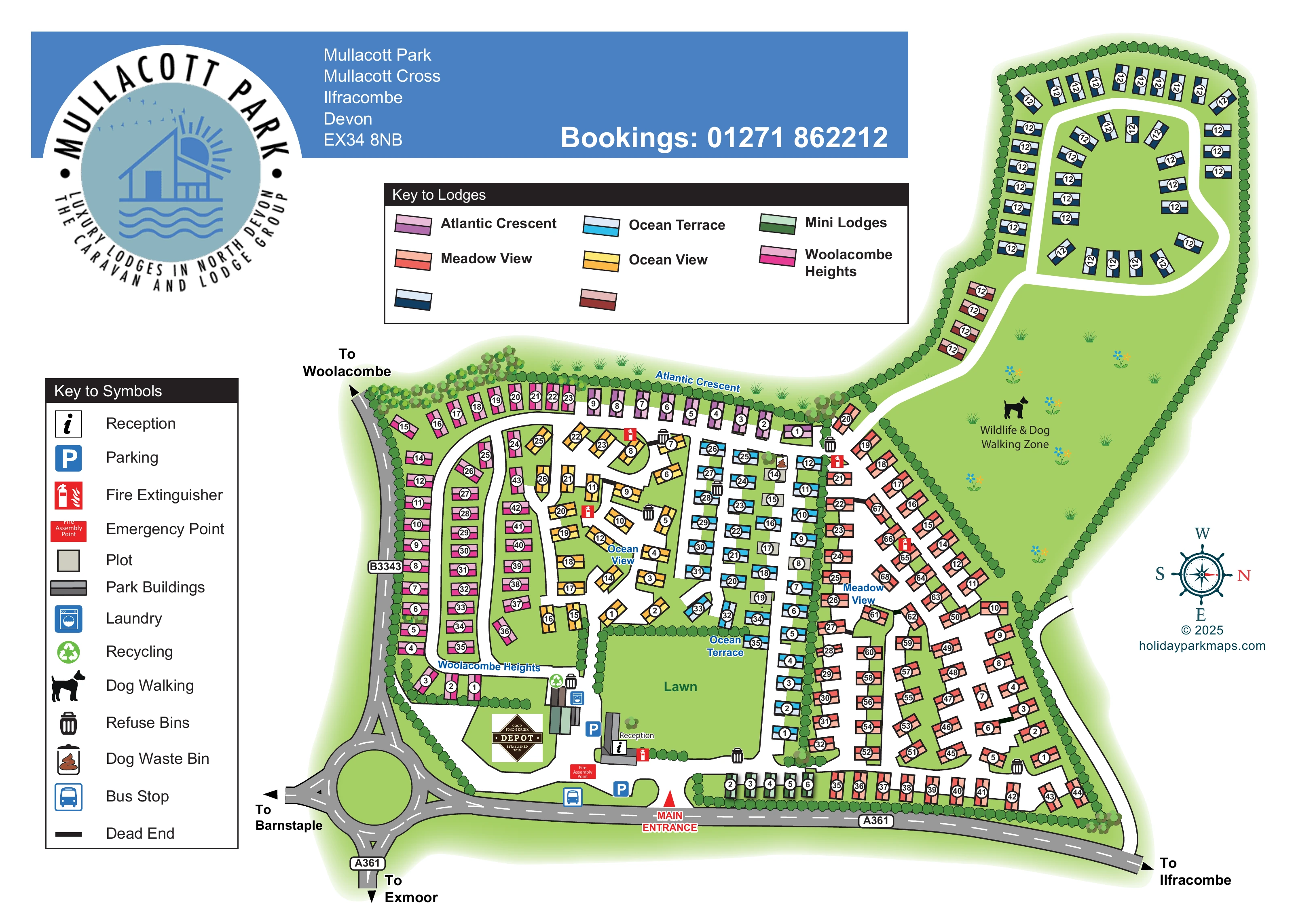
This illustrated map of Mullacott Park presents a sizeable lodge estate at Mullacott Cross, between Woolacombe and Ilfracombe in North Devon. Its distinctive shape combines a broad main accommodation area with a long green extension leading to a separate lodge loop. Colour is central to the design: named neighbourhoods such as Ocean View, Ocean Terrace, Meadow View and Woolacombe Heights are represented by different lodge colours, helping visitors recognise their destination before following individual plot labels.
The map also gives arrival a clear starting point. The A361, nearby roundabout and directions towards local destinations sit along the edge of the plan, while the main entrance leads to reception, parking and shared buildings. A large central lawn and the labelled Wildlife & Dog Walking Zone make the open spaces easy to distinguish from the accommodation roads.
For a lodge park with several interlinked neighbourhoods, this sample demonstrates how an overhead plan can combine individual-unit navigation, shared facilities and surrounding road context without relying on a perspective view.
The artwork is a single landscape-format overhead plan, supported here by overlapping enlargements of its legends and entrance area. A blue header carries the park address and bookings details, with the circular Mullacott Park logo overlapping its left end. Below it, a wide lodge key explains the main accommodation colours, while a separate tall symbol key occupies the left margin.
The main entrance is marked in red on the A361 along the lower edge. Reception and parking sit immediately inside, beside the central lawn. Nearby building footprints carry laundry and recycling symbols, and a Depot food-and-drink badge provides another recognisable entrance landmark. Refuse bins and fire extinguishers are distributed through the main lodge areas, with a fire assembly point close to arrival.
White internal roads divide the accommodation into distinct patterns. Woolacombe Heights follows the left-hand loop, Atlantic Crescent runs across the upper edge of the main estate, and Ocean View occupies a series of shorter branching lanes. Ocean Terrace forms rows beside the lawn, while Meadow View spreads across the right-hand road network. A short line of green Mini Lodges sits near the entrance. Grey plot symbols appear among some central rows.
Beyond the main body, a connecting road passes the elongated Wildlife & Dog Walking Zone and reaches a separate loop of dark-blue lodge symbols. Hedges frame this extension and most of the estate; tree clusters, flowers and grass tufts soften the schematic layout. Grey external roads, the roundabout, road-number shields and destination arrows supply local context. The compass shows north towards the right, reflecting the page's deliberately rotated orientation.
KEEP EXPLORING
Chosen for shared landscapes, accommodation or facilities.
 Explore the map ↗
United Kingdom
Woodland-framed Barnsoul map with mixed accommodation, shared facilities and paw-marked walking routes.
 Explore the map ↗
United Kingdom
A wooded, streamside park map with a linked farm, café, touring and cottage area.
 Explore the map ↗
United Kingdom
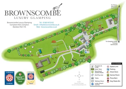
A branded rural glamping map combining named safari tents and distinctive structures with an orchard dog walk, shared amenities and farm-themed illustration.
Features may come from the sample artwork, its key or published park information. Approximate numbers describe the drawing and may cover only part of a park. They are intended to help you compare map examples. Current facilities and booking information should be checked with the park.
TAKE A CLOSER LOOK
View the illustrated map in detail or choose a file to download. These are sample maps; contact the park for current visitor information.


LET’S MAP YOUR PARK
For a map quotation, find your park and draw a rough boundary around it. The area you select helps us work out the design time and price.
Draw your park for a quote ↗Or talk to our map designers
01751 473136
 mullacottpark_large.png