
Tree and hedge enclosure
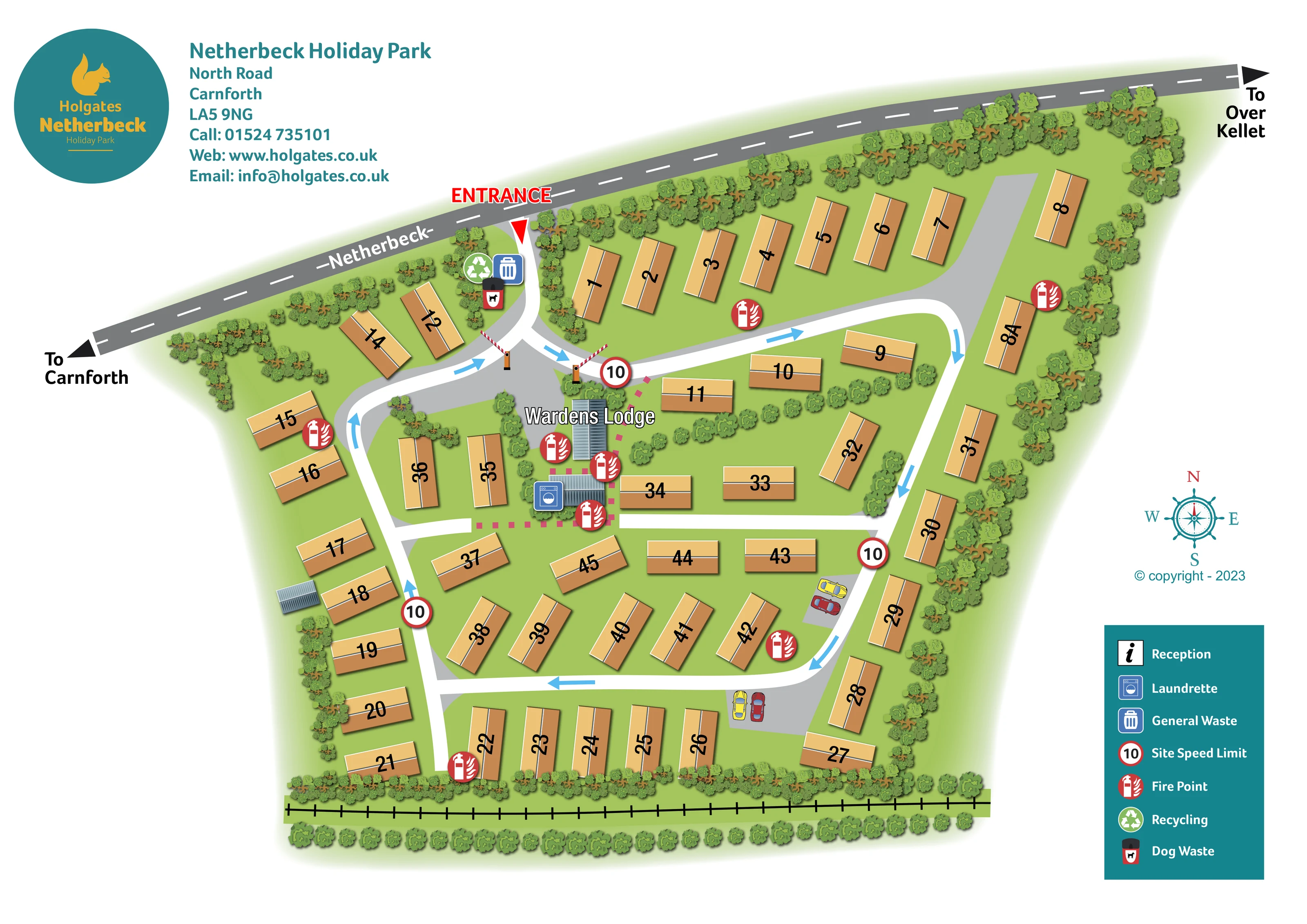
Dense illustrated trees frame much of the perimeter, while shorter planted lines divide some internal accommodation groups.
ILLUSTRATED PARK MAP · P224
North Road, Carnforth · United Kingdom
 Enlarge the map ↗
A SENSE OF THE PLACE
Netherbeck is a small Holgates holiday home ownership park near Carnforth, with views towards Warton Crag. Its setting is intended for a quieter stay throughout the holiday season.
Owners can also use leisure facilities at the separate Silverdale park, including its indoor swimming complex. The map focuses on Netherbeck's own holiday home plots and access routes.
LOOK CLOSER
Dense illustrated trees frame much of the perimeter, while shorter planted lines divide some internal accommodation groups.
A continuous light-green ground colour presents the homes as spaced across landscaped grass rather than within individually outlined plots.
A black line with regular transverse marks follows the lower edge between planted strips; its precise meaning is not identified in the legend.
A prominent red ENTRANCE label and triangular pointer identify the access from the road along the upper boundary.
Black arrowheads at opposite ends of the external road indicate Carnforth to the left and Over Kellet to the right.
Two red-and-white barrier arms are illustrated where the entrance meets the internal circulation routes.
White route bands over grey road surfaces connect the accommodation rows. Blue arrows show the illustrated circulation direction around the park.
A labelled grey-roofed building stands near the entrance junction and central service area.
A prominent red ENTRANCE label and triangular pointer identify the access from the road along the upper boundary.
Black arrowheads at opposite ends of the external road indicate Carnforth to the left and Over Kellet to the right.
Two red-and-white barrier arms are illustrated where the entrance meets the internal circulation routes.
White route bands over grey road surfaces connect the accommodation rows. Blue arrows show the illustrated circulation direction around the park.
A labelled grey-roofed building stands near the entrance junction and central service area.
A blue washing-machine symbol marks a grey-roofed service building immediately below the Wardens Lodge.
Three distinct symbols identify a grouped waste and recycling area beside the entrance approach.
Repeated red fire-point symbols appear beside accommodation rows and around the central service buildings.
Red-ringed signs marked 10 are repeated along the internal roads and explained as Site Speed Limit in the key.
Small grey roadside areas containing car illustrations appear in the lower and right-hand parts of the plan.
Reception is listed in the legend with an information symbol, but a corresponding mapped position is not clearly shown.
Dense illustrated trees frame much of the perimeter, while shorter planted lines divide some internal accommodation groups.
A continuous light-green ground colour presents the homes as spaced across landscaped grass rather than within individually outlined plots.
A black line with regular transverse marks follows the lower edge between planted strips; its precise meaning is not identified in the legend.
READING THE MAP
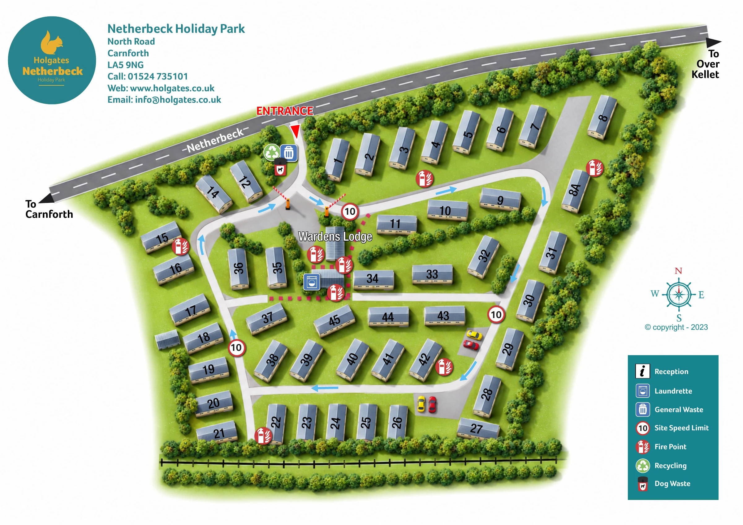
This illustrated map of Netherbeck Holiday Park presents a compact holiday-home setting on North Road in Carnforth. Roughly 45 homes are arranged around a clear internal road circuit, with trees enclosing the park and smaller planted divisions separating some of the rows. The design concentrates on finding a home and understanding the arrival layout, rather than depicting a large leisure complex.
A diagonal roadside frontage gives the page its distinctive shape. Directions towards Carnforth and Over Kellet sit at opposite ends, while a bold red entrance marker leads into the park. Blue arrows carry the circulation pattern through the accommodation, and large black numbers make individual homes easy to locate.
The Wardens Lodge and laundrette provide recognisable central landmarks. Waste, recycling and dog-waste symbols are grouped near the entrance, with fire points and speed-limit symbols distributed around the plan. Warm-toned home roofs, green landscaping and teal Holgates branding bring the practical information together in a single landscape-format illustration.
The plan occupies most of a white landscape page, with Netherbeck’s circular Holgates badge and contact details at upper left. Across the top, a grey external road rises diagonally towards the right. Its dashed centre line and large arrows distinguish it from the park roads, while labels point towards Carnforth and Over Kellet. A red entrance label and downward pointer identify the access into the site.
Inside the boundary, the homes follow the shape of the park. A long row runs beneath the upper roadside planting, further rows extend down the sides and across the lower edge, and shorter groups fill the interior. Each home is drawn as a two-tone roof rectangle with a prominent black number. The varied orientations preserve the character of the layout without requiring detailed building elevations or individual plot outlines.
Grey road surfaces, broad white route bands and blue arrows establish the circulation pattern. Two illustrated barrier arms sit near the entrance junction, and small car drawings identify roadside parking areas further into the park. Near the upper centre, the labelled Wardens Lodge and adjacent laundrette have ribbed grey roofs that stand apart from the accommodation. Pink square-dashed markings also connect this service area, although their meaning is not keyed.
The entrance-side waste cluster combines general waste, recycling and dog-waste symbols. Red fire-point icons recur around the site, alongside signs marked 10. Dense trees enclose the perimeter, with shorter planting lines dividing internal groups. A decorative compass and teal legend complete the right-hand margin; reception is included in the key without a clearly identifiable location on the plan.
 Enlarge this map ↗
KEEP EXPLORING
Chosen for shared landscapes, accommodation or facilities.
 Explore the map ↗
United Kingdom
Coastal park map with static-caravan rows, touring pitches, a camping field and two leisure clusters.
 Explore the map ↗
United Kingdom
A wooded Allerton park plan with colour-coded neighbourhoods, touring pitches and a central facilities hub.
 Explore the map ↗
United Kingdom
Illustrated coastal holiday-home plan with dense alphanumeric plot labels, orange-roofed amenities, a numbered facility key and beach-side context.
Features may come from the sample artwork, its key or published park information. Approximate numbers describe the drawing and may cover only part of a park. They are intended to help you compare map examples. Current facilities and booking information should be checked with the park.
LET’S MAP YOUR PARK
For a map quotation, find your park and draw a rough boundary around it. The area you select helps us work out the design time and price.
Draw your park for a quote ↗Or talk to our map designers
01751 473136