
Tree-lined touring grounds
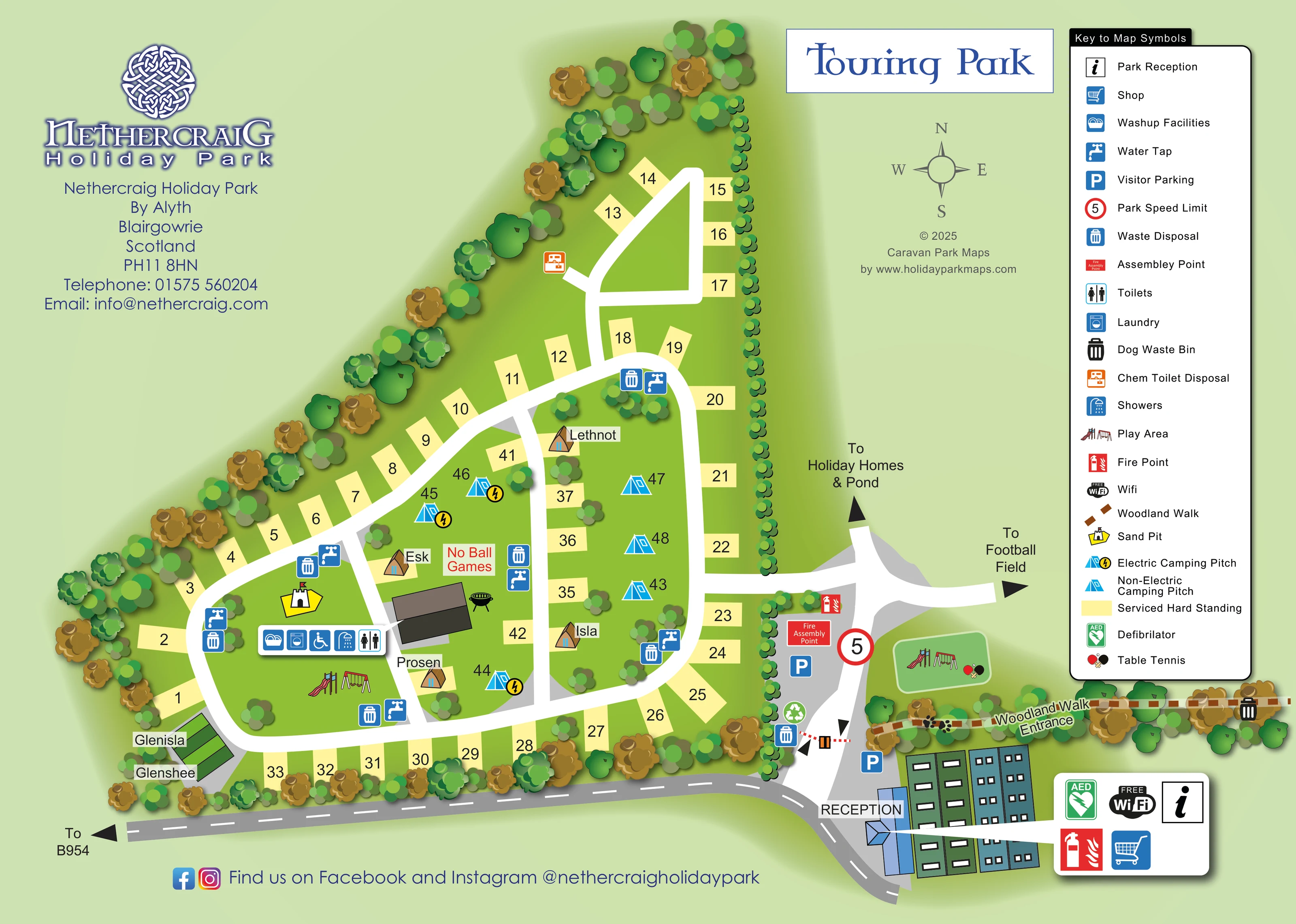
Dense illustrated trees frame the west and south boundaries, while a regular hedge-like line encloses the eastern edge. Scattered trees divide internal accommodation areas.
ILLUSTRATED PARK MAP · P225
Nethercraig Holiday Park, By Alyth, Blairgowrie, Scotland · United Kingdom
 Enlarge the map ↗
A SENSE OF THE PLACE
Nethercraig Holiday Park near Alyth offers lodges, caravan holiday homes and glamping accommodation. Different properties cater for couples, families and visitors travelling with pets.
Woodland paths start near reception and form a network through the trees. Decking is a feature of several accommodation options, with the map helping guests locate their property and understand the park's wooded setting.
LOOK CLOSER
Dense illustrated trees frame the west and south boundaries, while a regular hedge-like line encloses the eastern edge. Scattered trees divide internal accommodation areas.
Reception is labelled beside the southern entrance. A linked symbol panel identifies reception and a shop at this arrival complex.
A central service building is accompanied by a horizontal strip of toilet, shower, laundry and wash-up symbols.
A wheelchair pictogram appears in the service-building symbol strip, without an accompanying explanation of the provision it denotes.
Repeated blue tap and bin symbols mark service points beside the touring roads. A recycling symbol also appears near the entrance.
An orange disposal symbol is placed beside a short spur in the northern part of the touring section.
Blue parking symbols identify arrival-side parking near reception and the entrance junction.
Slide-and-swing illustrations mark a play area inside the southern touring loop and another in a rounded green enclosure east of the entrance.
Reception is labelled beside the southern entrance. A linked symbol panel identifies reception and a shop at this arrival complex.
A central service building is accompanied by a horizontal strip of toilet, shower, laundry and wash-up symbols.
A wheelchair pictogram appears in the service-building symbol strip, without an accompanying explanation of the provision it denotes.
Repeated blue tap and bin symbols mark service points beside the touring roads. A recycling symbol also appears near the entrance.
An orange disposal symbol is placed beside a short spur in the northern part of the touring section.
Blue parking symbols identify arrival-side parking near reception and the entrance junction.
Slide-and-swing illustrations mark a play area inside the southern touring loop and another in a rounded green enclosure east of the entrance.
A yellow sandcastle pictogram marks a sand pit near the western service points.
The bat-and-ball symbol is placed beside the eastern play area.
A small barbecue pictogram is drawn beside the central service building; it is not separately explained in the legend.
A Wi-Fi badge appears in the symbol panel linked to reception, rather than as a coverage diagram.
Fire-point symbols appear near reception and the entrance junction. The assembly point is labelled beside the entrance road, and an AED symbol is included in the reception callout.
Dense illustrated trees frame the west and south boundaries, while a regular hedge-like line encloses the eastern edge. Scattered trees divide internal accommodation areas.
A brown dashed route extends east from near reception, labelled Woodland Walk Entrance. Paw-print symbols and a dog waste bin accompany the illustrated route.
An eastward branch is labelled To Football Field; the field itself is outside the depicted area.
A northward branch at the entrance junction points towards Holiday Homes & Pond, neither of which is drawn in this section.
A grey road along the bottom is labelled towards the B954. Reception, parking and a barrier symbol establish the entrance to the white internal road network.
The artwork includes a circular 5 speed-limit sign near the entrance and a No Ball Games notice in the central grassed area.
READING THE MAP
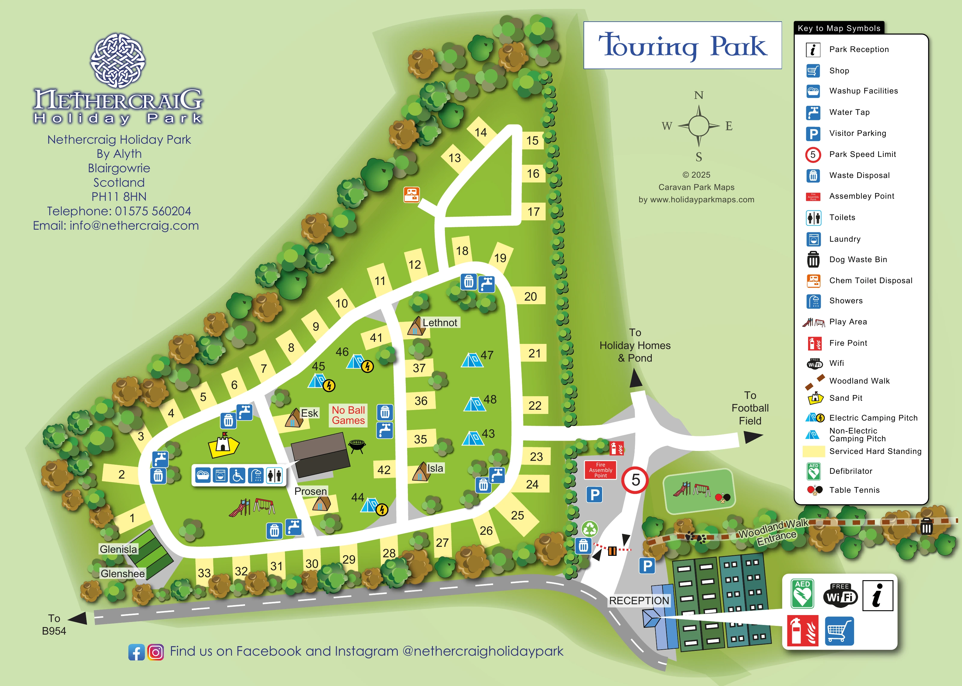
This illustrated map presents the touring section of Nethercraig Holiday Park, by Alyth in Scotland, as a tree-lined network of pitches, camping spaces and named accommodation. A broad white road circuit makes the site structure easy to follow, with pale-yellow hardstandings arranged along its edges and smaller grassed areas enclosed by internal lanes. Blue tent symbols distinguish electric and non-electric camping, while timber-coloured pod illustrations introduce a different accommodation style within the same plan.
The arrival area sits beside reception at the bottom of the page. From here, visitors can locate parking, follow the touring roads or identify the woodland walk entrance. Arrows also connect this section to the football field and to holiday homes and a pond beyond the drawing. Play areas, a sand pit, table tennis and everyday touring facilities add useful detail without competing with the numbered pitches.
The design combines a practical overhead plan with colourful landscape illustration. Nethercraig's Celtic-knot branding, a prominent Touring Park heading and a substantial symbol key give the page a clear identity and make it a useful example of mapping a mixed-accommodation touring area.
The plan is organised around an elongated, roughly triangular touring area. Its main white road sweeps around the southern and western pitches before climbing towards a smaller triangular loop at the northern end. Internal lanes divide the middle into green islands containing further hardstandings, camping symbols, scattered trees and named pod-like accommodation. Glenisla and Glenshee are illustrated as larger roofed buildings at the south-western corner, while Esk, Prosen, Isla and Lethnot are placed within the central grounds.
Reception anchors the southern arrival area beside the grey approach road, which is labelled towards the B954. Parking symbols, a barrier illustration, the assembly-point label and a speed-limit sign help establish this entrance zone. A white pointer links reception to an enlarged panel containing reception, shop, Wi-Fi, fire-point and defibrillator symbols. Branches beyond the entrance junction point towards the football field and towards holiday homes and a pond outside the mapped section.
The central service building has a compact row of wash-up, laundry, wheelchair, shower and toilet pictograms. Water taps and waste points recur beside the touring roads, with chemical toilet disposal marked further north. Recreation is shown through two slide-and-swing illustrations, a sand pit and table tennis beside the eastern play area. A small barbecue illustration and a No Ball Games notice appear near the central building.
Woodland is a strong visual frame rather than a detailed botanical depiction: overlapping green and ochre tree crowns surround the grounds, with individual trees punctuating the lawns. To the east, a brown dashed line labelled Woodland Walk Entrance continues through the trees. The single landscape-format page is completed by a right-hand legend, compass, blue park branding and contact information. The enlarged detail repeats part of this same artwork rather than showing an additional site section.
KEEP EXPLORING
Chosen for shared landscapes, accommodation or facilities.
 Explore the map ↗
United Kingdom
Woodland-framed Barnsoul map with mixed accommodation, shared facilities and paw-marked walking routes.
 Explore the map ↗
United Kingdom
A colour-zoned coastal park map with touring areas, woodland trails, ponds and a leisure club.
 Explore the map ↗
United Kingdom
Woodland holiday-park map with named accommodation areas, touring loops and illustrated recreation facilities.
Features may come from the sample artwork, its key or published park information. Approximate numbers describe the drawing and may cover only part of a park. They are intended to help you compare map examples. Current facilities and booking information should be checked with the park.
TAKE A CLOSER LOOK
View the illustrated map in detail or choose a file to download. These are sample maps; contact the park for current visitor information.


LET’S MAP YOUR PARK
For a map quotation, find your park and draw a rough boundary around it. The area you select helps us work out the design time and price.
Draw your park for a quote ↗Or talk to our map designers
01751 473136
 touring.png
 touring_large.png