
Woodland belts and planted glades
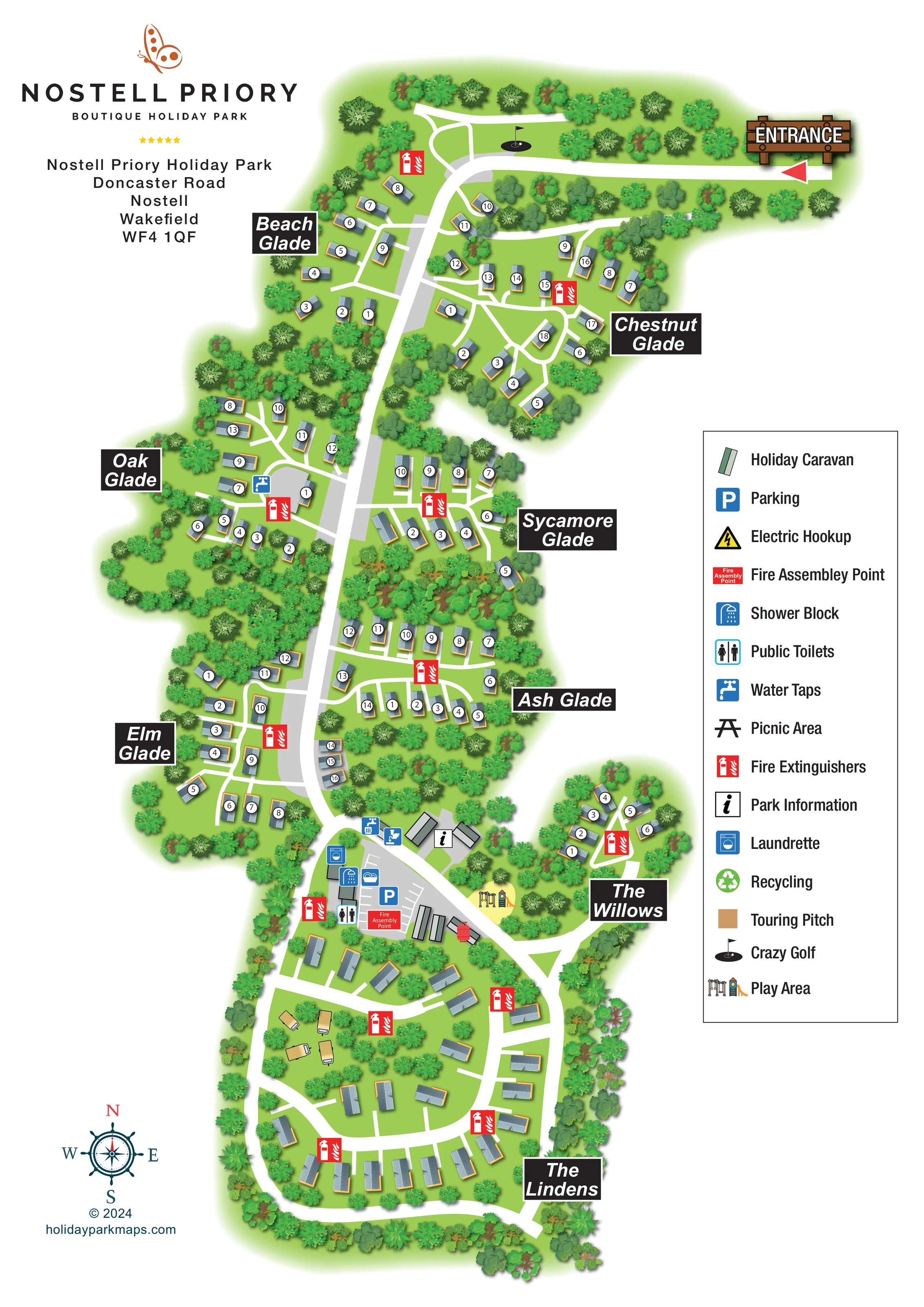
Dense illustrated trees enclose the park, separate accommodation clusters and surround individual units.
ILLUSTRATED PARK MAP · P229
Doncaster Road, Wakefield · United Kingdom
 Enlarge the map ↗
A SENSE OF THE PLACE
Nostell Priory Boutique Holiday Park is based at Doncaster Road, Wakefield. This is a holiday-home park within the Nostell estate's woodland setting near Wakefield. The park markets static holiday caravans and lodges for sale.
The park provides a café, essentials shop, laundry and children's play field. The operator promotes access to estate walking and cycling routes.
LOOK CLOSER
Dense illustrated trees enclose the park, separate accommodation clusters and surround individual units.
The plan labels Beach Glade, Chestnut Glade, Oak Glade, Sycamore Glade, Ash Glade, Elm Glade, The Willows and The Lindens.
An illustrated timber entrance sign and red arrow mark arrival at the upper-right edge, leading westwards into the main internal route.
A long north–south route serves short branches and loops through the glades, then connects to a broader loop system around The Lindens.
An information symbol identifies buildings beside the main route at the central-lower facilities hub.
A grey parking court with white bay markings and a blue P symbol sits beside the service buildings.
A washing-machine symbol marks the laundrette in the service-building group west of the parking court.
Separate shower and public-toilet symbols identify facilities alongside the central parking area.
An illustrated timber entrance sign and red arrow mark arrival at the upper-right edge, leading westwards into the main internal route.
A long north–south route serves short branches and loops through the glades, then connects to a broader loop system around The Lindens.
Dense illustrated trees enclose the park, separate accommodation clusters and surround individual units.
The plan labels Beach Glade, Chestnut Glade, Oak Glade, Sycamore Glade, Ash Glade, Elm Glade, The Willows and The Lindens.
An information symbol identifies buildings beside the main route at the central-lower facilities hub.
A grey parking court with white bay markings and a blue P symbol sits beside the service buildings.
A washing-machine symbol marks the laundrette in the service-building group west of the parking court.
Separate shower and public-toilet symbols identify facilities alongside the central parking area.
Blue tap symbols appear in Oak Glade and near the main facilities hub.
Swings and a slide illustrate a play area on a yellow patch beside the facilities hub and the route towards The Willows.
A black putting-hole and flag symbol locates crazy golf on the green beside the entrance approach.
A red labelled assembly-point marker is positioned in the central parking court.
Repeated red extinguisher symbols are distributed through the accommodation areas and near the service hub.
A yellow electrical symbol is included in the key; a corresponding location is not clearly identifiable on the plan.
The legend includes a picnic-table symbol, without a clearly identifiable matching placement on the plan.
A green recycling symbol appears in the legend, but its location is not clearly marked in the illustrated park.
Operator information describes a café and essentials shop; neither is explicitly labelled on this artwork.
Operator information promotes access to estate walking and cycling routes. These wider routes are not drawn on this park plan.
READING THE MAP
This illustrated map of Nostell Priory Boutique Holiday Park presents a woodland holiday-home setting near Wakefield as a series of distinct, easily recognised neighbourhoods. Rather than showing accommodation as one continuous grid, the artwork separates the caravans into green pockets with names including Chestnut Glade, Oak Glade, Ash Glade and The Willows. Dense tree illustrations give those areas a strong visual identity while keeping the connecting routes clear.
The tall portrait layout follows the shape of the park, from the prominently marked entrance at the upper right to the looping roads of The Lindens at the southern end. Numbered holiday caravans occupy most of the plan, with a small touring group shown in the lower section. A facilities hub brings together parking, park information, laundry, showers and toilets, while the play area and crazy golf provide recognisable leisure landmarks.
Butterfly branding, bold black area labels and a spacious symbol key complete a design that balances the park's wooded character with practical navigation.
The plan begins with a timber-style entrance sign and red arrow at the north-eastern edge. A tree-lined approach runs leftwards before joining the long internal spine. Beach Glade sits to the west of this upper route, with Chestnut Glade forming a larger branching cluster to the east. Further south, Oak and Sycamore Glades face one another across the main route, followed by Elm and Ash Glades. Each group is framed by planting rather than a hard enclosing boundary.
Most holiday caravans are drawn as small, shaded roof forms with ochre-edged bases and white circular number badges. Their varied angles follow the branching routes and curved edges of the clearings. Broad white connections remain conspicuous against the green ground, while grey sections distinguish much of the main spine and the parking court.
The central-lower service area is a useful visual anchor. Park information is marked beside a group of larger buildings, and the neighbouring parking court has individual bay markings. Blue symbols identify the laundrette, shower block, public toilets and water taps. A red fire assembly marker sits within the parking area, with extinguisher symbols repeated throughout the park. The children's play area is illustrated beside the route leading towards the compact Willows cluster.
Below this hub, The Lindens spreads around broad curved routes, with holiday caravans and a small group of tan touring-caravan illustrations among scattered trees. Crazy golf is marked separately near the entrance approach. The right-hand key also includes electric hookup, picnic and recycling symbols, although their positions are not clearly identified on the plan. A compass, butterfly logo and address block complete this single portrait artwork.
KEEP EXPLORING
Chosen for shared landscapes, accommodation or facilities.
 Explore the map ↗
United Kingdom
A wooded Allerton park plan with colour-coded neighbourhoods, touring pitches and a central facilities hub.
 Explore the map ↗
United Kingdom
A wooded, mixed-accommodation park plan with winding lanes, a pool, camping areas and a clear facility key.
 Explore the map ↗
United Kingdom
Woodland-framed Barnsoul map with mixed accommodation, shared facilities and paw-marked walking routes.
Features may come from the sample artwork, its key or published park information. Approximate numbers describe the drawing and may cover only part of a park. They are intended to help you compare map examples. Current facilities and booking information should be checked with the park.
TAKE A CLOSER LOOK
View the illustrated map in detail or choose a file to download. These are sample maps; contact the park for current visitor information.
LET’S MAP YOUR PARK
For a map quotation, find your park and draw a rough boundary around it. The area you select helps us work out the design time and price.
Draw your park for a quote ↗Or talk to our map designers
01751 473136