
River Lynher
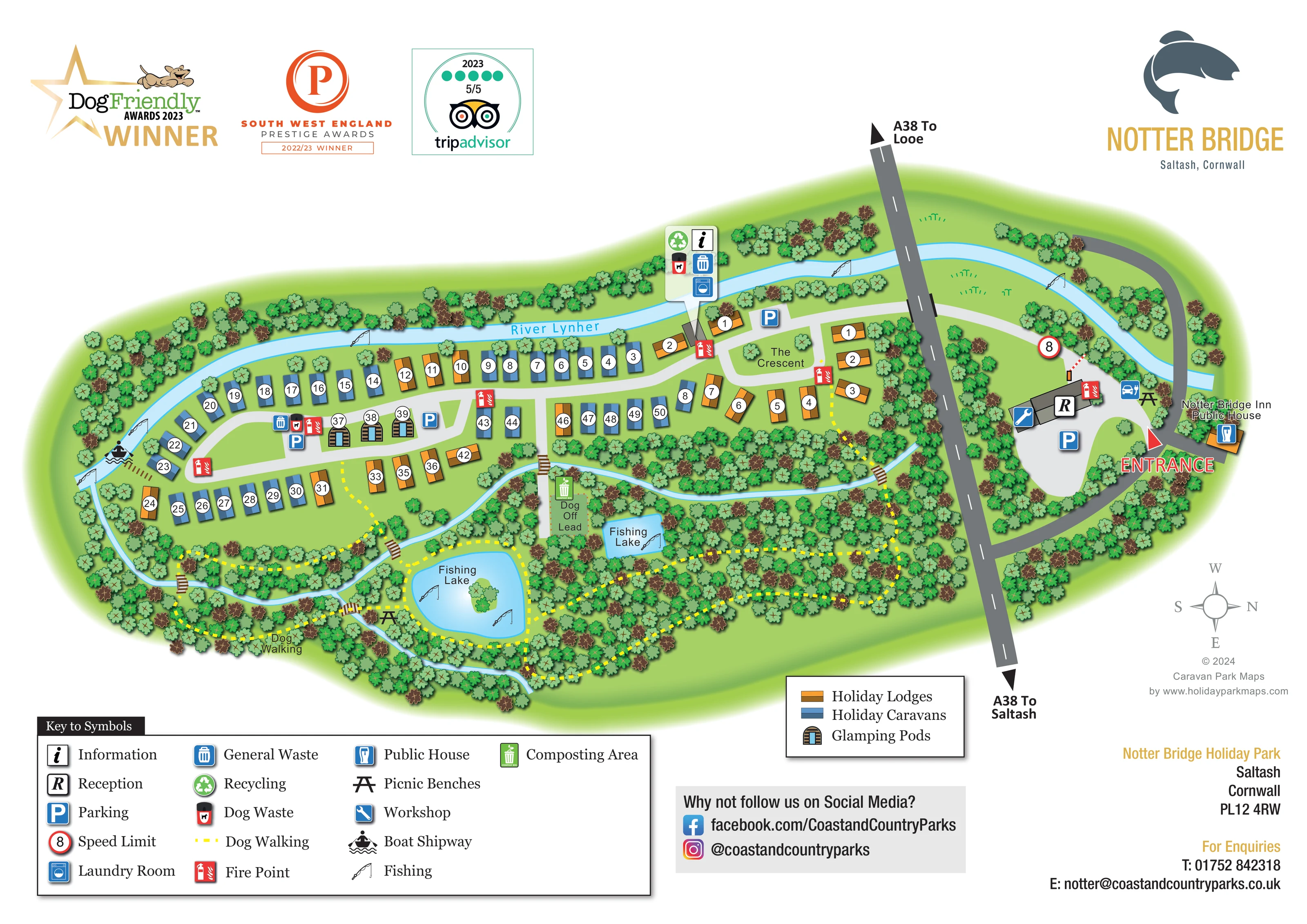
Named pale-blue river following the long upper boundary and curving around the western end of the accommodation area.
ILLUSTRATED PARK MAP · P230
Notter Bridge, near Saltash, Cornwall · United Kingdom
 Enlarge the map ↗
A SENSE OF THE PLACE
Notter Bridge Holiday Park is based at Notter Bridge, near Saltash, Cornwall. This is a riverside woodland park on the River Lynher in south-east Cornwall. The park offers holiday caravans, lodges and ensuite glamping pods, including some private hot-tub options.
Direct river access is promoted for fishing, kayaking and paddleboarding.
LOOK CLOSER
Named pale-blue river following the long upper boundary and curving around the western end of the accommodation area.
Dense illustrated trees frame the river, accommodation, entrance and southern walking area.
Two labelled lakes sit in the woodland below the accommodation; the larger lake contains a small illustrated island.
Fishing-rod symbols appear at the lakes and at several points along the River Lynher.
A prominent red entrance label and arrow identify the arrival area beside the Notter Bridge Inn.
A dark-grey through-road divides the main accommodation landscape from the reception-side area, with arrows towards Looe and Saltash.
An R symbol marks the long building in the arrival area on the right of the main road.
Information and laundry symbols appear in a grouped callout pointing to the small riverside service building near the eastern end of the accommodation.
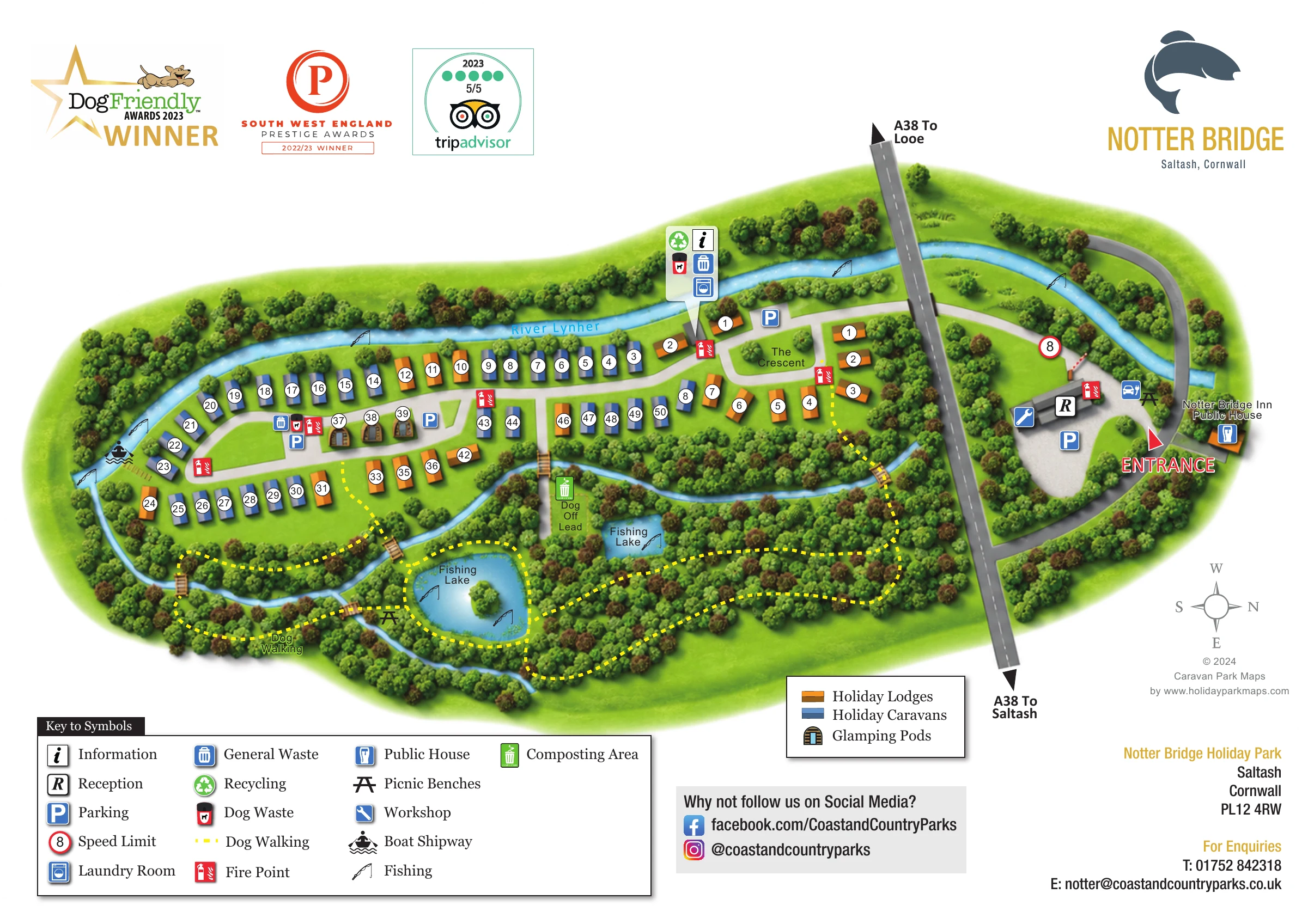
Named pale-blue river following the long upper boundary and curving around the western end of the accommodation area.
Dense illustrated trees frame the river, accommodation, entrance and southern walking area.
Two labelled lakes sit in the woodland below the accommodation; the larger lake contains a small illustrated island.
Fishing-rod symbols appear at the lakes and at several points along the River Lynher.
A prominent red entrance label and arrow identify the arrival area beside the Notter Bridge Inn.
A dark-grey through-road divides the main accommodation landscape from the reception-side area, with arrows towards Looe and Saltash.
An R symbol marks the long building in the arrival area on the right of the main road.
Information and laundry symbols appear in a grouped callout pointing to the small riverside service building near the eastern end of the accommodation.
Blue P symbols mark parking in the arrival area and at several points within the accommodation layout.
General waste, recycling and dog-waste symbols are grouped around service locations; a green composting symbol appears beside the off-lead area.
Repeated red fire-point symbols are distributed through the accommodation roads and near reception.
A blue spanner symbol identifies a workshop at the reception-side building.
The named public house is shown beside the entrance approach, with a pint-glass symbol.
Picnic-table symbols appear near the larger fishing lake and in the arrival-side riverside area.
A boat-launch symbol marks river access at the western end of the accommodation. The legend labels this 'Boat Shipway'.
Yellow dashed paths form a woodland walking network around the lakes and southern park boundary, with links towards the accommodation.
A labelled green area lies between the accommodation and the smaller fishing lake.
Small timber-style bridges connect paths across the narrow water channels below the accommodation.
A named curved access loop organises a compact lodge group at the eastern end of the main accommodation area.
A red-ringed sign showing 8 appears near the arrival-side access road; no unit is stated.
READING THE MAP
This illustrated map of Notter Bridge Holiday Park places its riverside and woodland setting at the centre of the visitor experience. The River Lynher curves around the accommodation, while two fishing lakes and a network of dog-walking paths fill the wooded area below. The result is a site plan that explains both where guests are staying and how the surrounding landscape fits together.
Holiday caravans, lodges and a small group of glamping pods each have their own visual treatment. Blue and ochre accommodation symbols follow the internal roads, with white number discs helping visitors locate individual units. The named Crescent provides another useful landmark within the eastern accommodation group.
Arrival is given a clear visual focus beside reception and the Notter Bridge Inn. Parking, laundry, information, waste points and fire points are identified through a separate symbol key, while the A38 and its destination arrows establish the wider road context. Fish branding, award graphics and a contact panel complete a practical visitor sheet with a distinctly Cornish riverside identity.
The main plan is arranged as a long, gently curving accommodation area bordered by the River Lynher. Rows of blue holiday caravans and ochre lodges follow pale-grey access roads, with shorter inner rows and a central group of illustrated glamping pods. White circular labels identify individual units without requiring detailed building drawings. At the eastern end, The Crescent names a compact curved road serving a separate lodge group.
Below the accommodation, dense tree symbols enclose two labelled fishing lakes and several narrow water channels. The larger lake includes a small island. Yellow dashed dog-walking routes loop through this landscape, connecting lake edges, woodland paths and small timber-style bridges. A labelled dog off-lead area provides a further landmark between the buildings and lakes. Fishing symbols appear beside the lakes and along the river, while a boat-launch symbol marks access at the western end.
The dark-grey A38 cuts through the right-hand portion of the artwork, with arrows towards Looe and Saltash. Beyond it, a prominent entrance label anchors the reception-side forecourt, parking, workshop and nearby Notter Bridge Inn. Further parking and service points are distributed among the accommodation. A compact riverside callout groups information, laundry and waste-related symbols, and red fire-point icons stand out throughout the plan.
The page uses two complementary keys: a broad facility legend at lower left and a smaller accommodation legend towards the lower right. Branding and dated award graphics occupy the upper margin, with social links, contact details and a compass below. The enlarged detail views repeat these lower-page panels; they are not separate park sections or additional maps.
 Enlarge this map ↗
KEEP EXPLORING
Chosen for shared landscapes, accommodation or facilities.
 Explore the map ↗
United Kingdom
A woodland estate park map combining caravan loops, touring pitches, riverside paths and Bruce’s Cave landmarks.
 Explore the map ↗
United Kingdom
Woodland park map with mixed pitches, bell tents, lodges and a fishing lake.
 Explore the map ↗
United Kingdom
Illustrated lakeside park plan with numbered holiday units, leisure buildings and a looping Woodland Walk.
Features may come from the sample artwork, its key or published park information. Approximate numbers describe the drawing and may cover only part of a park. They are intended to help you compare map examples. Current facilities and booking information should be checked with the park.
TAKE A CLOSER LOOK
View the illustrated map in detail or choose a file to download. These are sample maps; contact the park for current visitor information.


LET’S MAP YOUR PARK
For a map quotation, find your park and draw a rough boundary around it. The area you select helps us work out the design time and price.
Draw your park for a quote ↗Or talk to our map designers
01751 473136