
Tree-lined parkland
Dense illustrated trees enclose the park boundary, with scattered trees and larger planted groups separating accommodation and facilities.
ILLUSTRATED PARK MAP · P554
Warren Road, Dawlish Warren, Devon · United Kingdom
 Enlarge the map ↗
A SENSE OF THE PLACE
Oakcliff Holiday Park is based at Warren Road, Dawlish Warren, Devon. Parkland surrounds a Georgian house near Dawlish Warren beach. Holiday-home ownership is also offered. The park offers lodges, mini lodges, static caravans and holiday cottages.
Its own outdoor swimming pool is described as open in the summer season.
LOOK CLOSER
Dense illustrated trees enclose the park boundary, with scattered trees and larger planted groups separating accommodation and facilities.
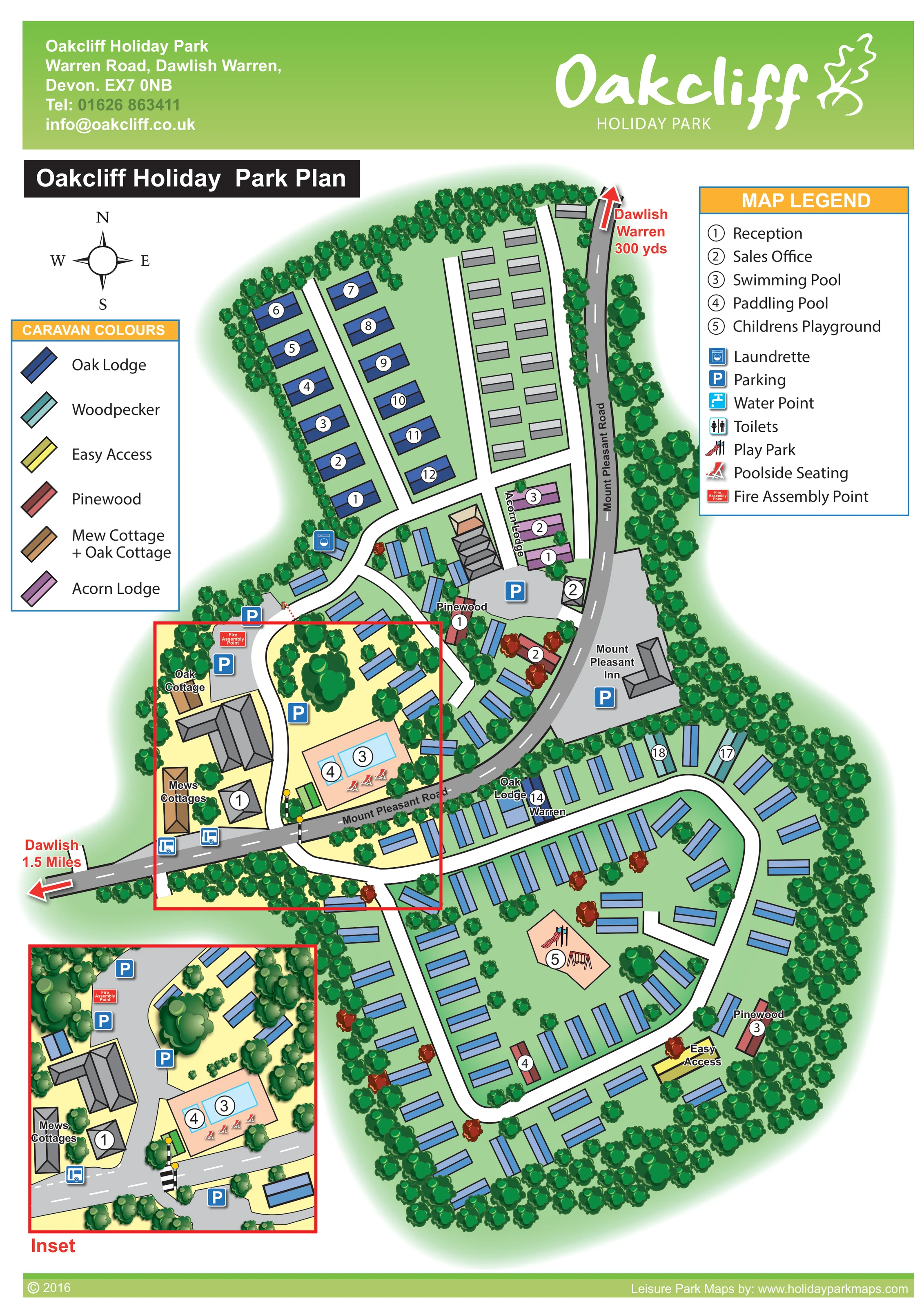
Numbered facility 1 occupies a small building beside the cottages, close to Mount Pleasant Road and the central arrival area.
Numbered facility 2 is shown beside Mount Pleasant Road near the Acorn Lodge group and a parking area.
A rectangular outdoor pool, numbered 3, sits in a peach-coloured pool enclosure near reception.
A smaller pool, numbered 4, is illustrated alongside the main swimming pool.
Small red-and-white reclining-chair symbols identify seating beside the pools.
Numbered facility 5 occupies a peach-coloured area within the southern accommodation loops, illustrated with a slide and swings.
A blue washing-machine symbol marks a building beside the approach to the northern Oak Lodge group.
Numbered facility 1 occupies a small building beside the cottages, close to Mount Pleasant Road and the central arrival area.
Numbered facility 2 is shown beside Mount Pleasant Road near the Acorn Lodge group and a parking area.
A rectangular outdoor pool, numbered 3, sits in a peach-coloured pool enclosure near reception.
A smaller pool, numbered 4, is illustrated alongside the main swimming pool.
Small red-and-white reclining-chair symbols identify seating beside the pools.
Numbered facility 5 occupies a peach-coloured area within the southern accommodation loops, illustrated with a slide and swings.
A blue washing-machine symbol marks a building beside the approach to the northern Oak Lodge group.
Blue P symbols mark several grey parking areas around the cottages, central facilities, sales office and neighbouring inn.
A red assembly-point sign is mapped beside parking near Oak Cottage and repeated in the facilities inset.
The legend includes a tap symbol, but a corresponding location is not clearly identifiable on the main plan.
Toilets appear in the symbol key; no clear mapped position can be established from this artwork.
The neighbouring inn is labelled beside Mount Pleasant Road, with an illustrated building and adjacent parking.
Dense illustrated trees enclose the park boundary, with scattered trees and larger planted groups separating accommodation and facilities.
The grey public road curves through the composition, separating the northern accommodation from the larger southern loops.
White, black-edged lanes connect the northern rows and form rounded loops through the southern accommodation.
A striped crossing with yellow-topped posts is drawn on Mount Pleasant Road near reception and the pool area.
A red arrow at the northern end of Mount Pleasant Road is labelled Dawlish Warren, 300 yds.
A red arrow at the western road edge is labelled Dawlish, 1.5 Miles.
The park context describes parkland around a Georgian house near Dawlish Warren beach; the map does not explicitly identify a building as that house.
READING THE MAP
This illustrated map of Oakcliff Holiday Park places a tree-lined Devon holiday setting around a clear network of roads, accommodation groups and visitor facilities. Based at Dawlish Warren, the park is shown in two contrasting parts: orderly northern rows of lodges and other holiday accommodation, and a larger southern area where caravan-style holiday homes follow rounded access lanes. Mount Pleasant Road runs between them, giving the plan a strong organising feature and connecting the site to labelled directions for Dawlish and Dawlish Warren.
The central facilities receive particular attention. Reception, cottages, parking, the swimming pool and paddling pool are gathered around the road crossing, while the children's playground sits within the southern accommodation area. A red-bordered inset makes the busy reception and pool area easier to read without interrupting the overall view.
Green parkland, individual tree canopies and simplified roof illustrations give the plan its character. Separate keys explain accommodation colours and visitor symbols, making this a useful sample for parks that need to distinguish several accommodation ranges while keeping everyday guest orientation straightforward.
The main plan fills a portrait page beneath Oakcliff's green branded header and a bold black title panel. Its overhead layout is softened by illustrated trees, shaded roofs and a green glow around the site boundary. Mount Pleasant Road curves from the left-hand edge towards the top of the page, with red directional arrows to Dawlish and Dawlish Warren. The neighbouring Mount Pleasant Inn and its parking area provide a recognisable landmark beside the road.
North of the central facilities, dark-blue Oak Lodge units line a straight internal lane. A separate row of grey units lies closer to Mount Pleasant Road, while three purple Acorn Lodge units occupy a short side section near the sales office. Further south, blue caravan-style units follow an extensive arrangement of curving white lanes. Selected accommodation is picked out in teal, yellow and muted red, with labels including Woodpecker, Easy Access and Pinewood. Oak Cottage and Mews Cottages sit near reception rather than within the main southern rows.
The facility key identifies reception, the sales office, swimming pool, paddling pool and children's playground through numbered white circles. Parking and a laundrette are marked with blue pictograms. Poolside chairs and the playground's slide and swings add immediately recognisable detail. The legend also includes water-point and toilet symbols, although their positions are not clear on the plan.
A red rectangle highlights the central facilities area, which is repeated at a larger scale in the lower-left inset. This enlargement clarifies reception, the cottages, pools, parking, assembly point and illustrated road crossing. It is part of the same artwork, not a second park section. The separate caravan-colour key, compass and restrained use of accommodation numbers complete the wayfinding system.
KEEP EXPLORING
Chosen for shared landscapes, accommodation or facilities.
 Explore the map ↗
United Kingdom
A colour-zoned coastal park map with touring areas, woodland trails, ponds and a leisure club.
 Explore the map ↗
United Kingdom
Colour-coded accommodation, central leisure facilities and coastal paths on an illustrated headland park map.
 Explore the map ↗
United Kingdom
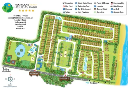
Illustrated Suffolk coastal park map with planted accommodation rows, central pitches, leisure facilities and beach directions.
Features may come from the sample artwork, its key or published park information. Approximate numbers describe the drawing and may cover only part of a park. They are intended to help you compare map examples. Current facilities and booking information should be checked with the park.
TAKE A CLOSER LOOK
View the illustrated map in detail or choose a file to download. These are sample maps; contact the park for current visitor information.
LET’S MAP YOUR PARK
For a map quotation, find your park and draw a rough boundary around it. The area you select helps us work out the design time and price.
Draw your park for a quote ↗Or talk to our map designers
01751 473136