
Fishing lake
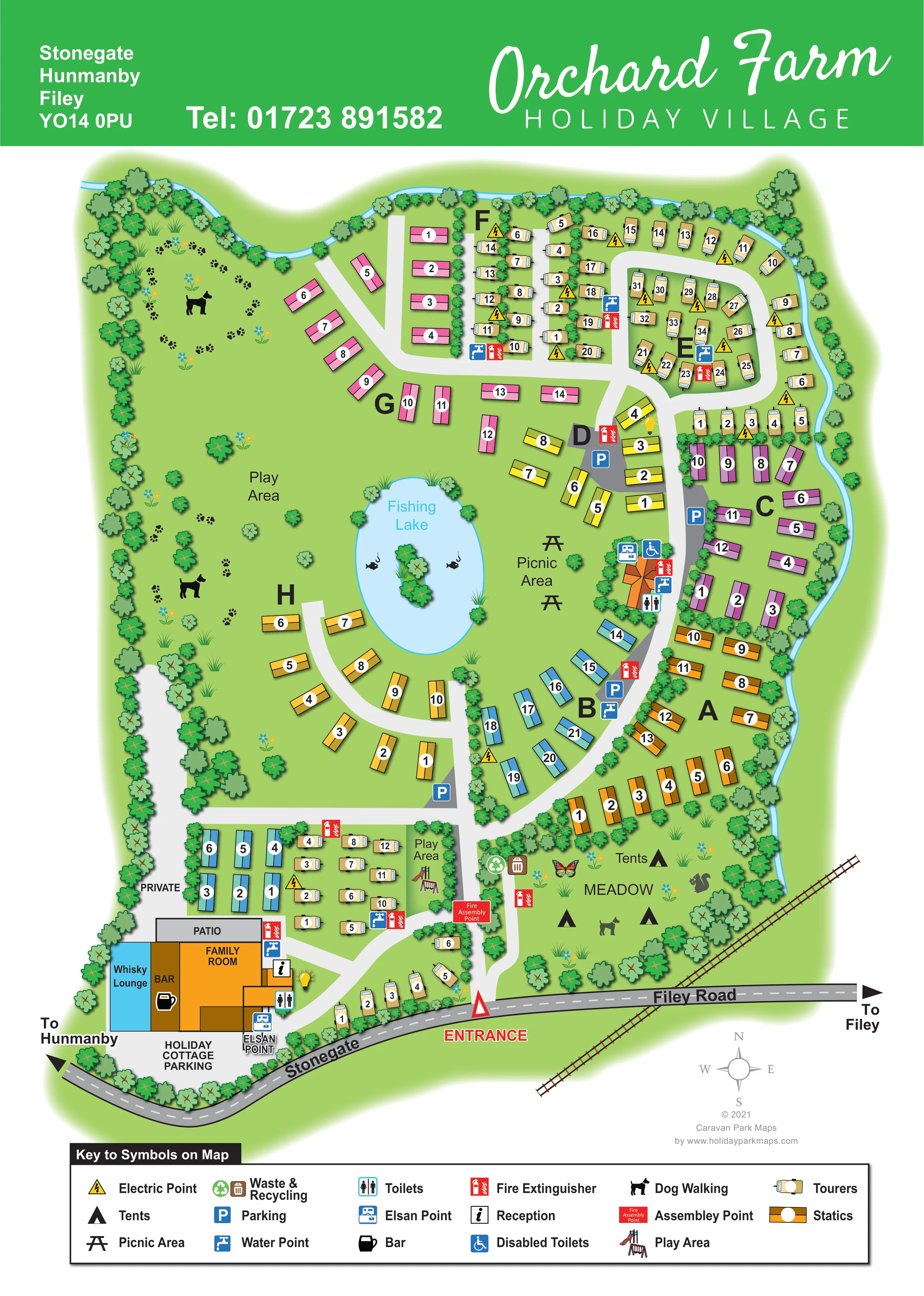
An oval blue lake with a planted island forms a central landmark between accommodation groups.
ILLUSTRATED PARK MAP · P558
Stonegate, Hunmanby, Filey · United Kingdom
 Enlarge the map ↗
A SENSE OF THE PLACE
Orchard Farm Holiday Park is located at Hunmanby near Filey on the Yorkshire coast. It combines holiday home ownership with self-catering accommodation and touring provision.
The park offers a base for visits to Filey, Scarborough, Bridlington and Cayton Bay. The map shows the arrangement of accommodation and shared facilities within the grounds, including areas developed for holiday homes.
LOOK CLOSER
An oval blue lake with a planted island forms a central landmark between accommodation groups.
An open green meadow occupies the lower-right portion of the park beside the entrance route.
A narrow blue watercourse follows the upper boundary and continues down the eastern side.
Dense illustrated trees enclose the grounds and separate accommodation groups, with shrubs and flowers across the open lawns.
An information symbol marks reception beside the entrance-side social building.
The main building at the lower left includes separately labelled BAR and Whisky Lounge spaces.
A large orange section of the entrance-side building is labelled FAMILY ROOM.
A long grey patio adjoins the upper side of the social building.
An information symbol marks reception beside the entrance-side social building.
The main building at the lower left includes separately labelled BAR and Whisky Lounge spaces.
A large orange section of the entrance-side building is labelled FAMILY ROOM.
A long grey patio adjoins the upper side of the social building.
An oval blue lake with a planted island forms a central landmark between accommodation groups.
Picnic-table symbols and a label mark the grass immediately to the right of the lake.
A broad western lawn is labelled Play Area, and another play area with an equipment illustration is shown near the lower touring pitches.
Dog silhouettes and paw-print trails mark the western green space and the tent meadow.
Toilet symbols appear beside the entrance building and at a smaller central service building.
A wheelchair symbol, described as Disabled Toilets in the key, appears at the central service building.
Elsan symbols are shown at the entrance-side facilities and the central service building.
Blue tap symbols are distributed among the accommodation groups and service buildings.
Yellow triangular electricity symbols appear throughout touring areas and at selected other positions.
Paired waste and recycling symbols are positioned beside the lower internal route near the meadow.
Blue parking symbols mark several internal bays; a larger entrance-side area is labelled Holiday Cottage Parking.
Red extinguisher symbols are repeated across the plan, with a labelled fire assembly point beside the lower play area and entrance route.
A prominent red ENTRANCE label marks the access from the Stonegate and Filey Road frontage.
The road curves across the bottom of the plan, with directional arrows towards Hunmanby and Filey.
A pale-grey central route branches into short spurs and curved loops serving the accommodation sections.
An open green meadow occupies the lower-right portion of the park beside the entrance route.
A narrow blue watercourse follows the upper boundary and continues down the eastern side.
Dense illustrated trees enclose the grounds and separate accommodation groups, with shrubs and flowers across the open lawns.
A diagonal railway graphic crosses the lower-right road frontage; no station or visitor access is indicated.
READING THE MAP
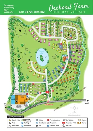
This illustrated map of Orchard Farm Holiday Village brings together caravan accommodation, touring pitches and an open tent meadow in a single portrait plan. Set at Hunmanby near Filey on the Yorkshire coast, the park is presented as a tree-lined site with a fishing lake at its centre and a broad recreation lawn along its western side.
The map gives arriving visitors a clear starting point: the entrance is highlighted beside Stonegate and Filey Road, with reception, the bar, Whisky Lounge and family room grouped nearby. From there, pale-grey roads lead through lettered accommodation sections, each using local plot numbers and easily distinguished caravan symbols. Colour adds another layer of recognition to the static-caravan groups, while touring caravans have their own cream illustration.
Beyond the accommodation, the artwork makes room for the details that shape a stay: picnic tables by the lake, play areas, dog-walking space, parking and distributed service points. Its large bottom legend keeps those practical symbols separate from the more decorative trees, flowers and wildlife, balancing visitor information with a friendly illustrated character.
The plan is arranged around a southern entrance, a central road spine and a series of curved branches serving the accommodation. Stonegate and Filey Road run across the bottom, with arrows towards Hunmanby and Filey. A diagonal railway graphic adds context to the lower-right frontage, while a narrow blue watercourse follows the northern and eastern boundaries.
Lettered sections A–H divide the numbered caravan groups. Static caravans appear as coloured rectangular units, with orange, blue, mauve, yellow and pink helping to separate neighbouring areas. Touring caravans use cream bodies with small towbar details and are particularly prominent in the upper half. Smaller touring groups also sit near the entrance-side facilities. The meadow to the right of the entrance is labelled for tents and illustrated as open grass rather than a numbered pitch grid.
The fishing lake is a strong central landmark, drawn with a small planted island and birds on the water. Picnic tables occupy its eastern side, while the western lawn carries play-area and dog-walking information. Another play area, illustrated with equipment, sits near the lower touring pitches.
At the lower left, the main social building is divided into the Whisky Lounge, bar and family room, with an adjoining patio. Reception and toilet symbols cluster beside it, along with an Elsan point and holiday cottage parking. A smaller central service building carries toilet, accessible-toilet and disposal symbols. Water points, electricity, parking and fire extinguishers recur around the roads, with waste and recycling and a fire assembly point near the lower route.
A green branded header and a wide symbol key frame the single-page artwork. The enlarged legend views show this same key in detail rather than additional park areas.
KEEP EXPLORING
Chosen for shared landscapes, accommodation or facilities.
 Explore the map ↗
United Kingdom
Orchard Holiday Park map with curved accommodation clusters, dog-walking lawns and a named waterside boundary.
 Explore the map ↗
United Kingdom
Illustrated caravan park plan with woodland and riverside walks, fishing pools and wildlife panels.
 Explore the map ↗
United Kingdom
Colour-coded touring and camping map beside Afon Llafar and Bala Lake, with bilingual Glanllyn branding.
Features may come from the sample artwork, its key or published park information. Approximate numbers describe the drawing and may cover only part of a park. They are intended to help you compare map examples. Current facilities and booking information should be checked with the park.
TAKE A CLOSER LOOK
View the illustrated map in detail or choose a file to download. These are sample maps; contact the park for current visitor information.


LET’S MAP YOUR PARK
For a map quotation, find your park and draw a rough boundary around it. The area you select helps us work out the design time and price.
Draw your park for a quote ↗Or talk to our map designers
01751 473136