
Two fishing ponds
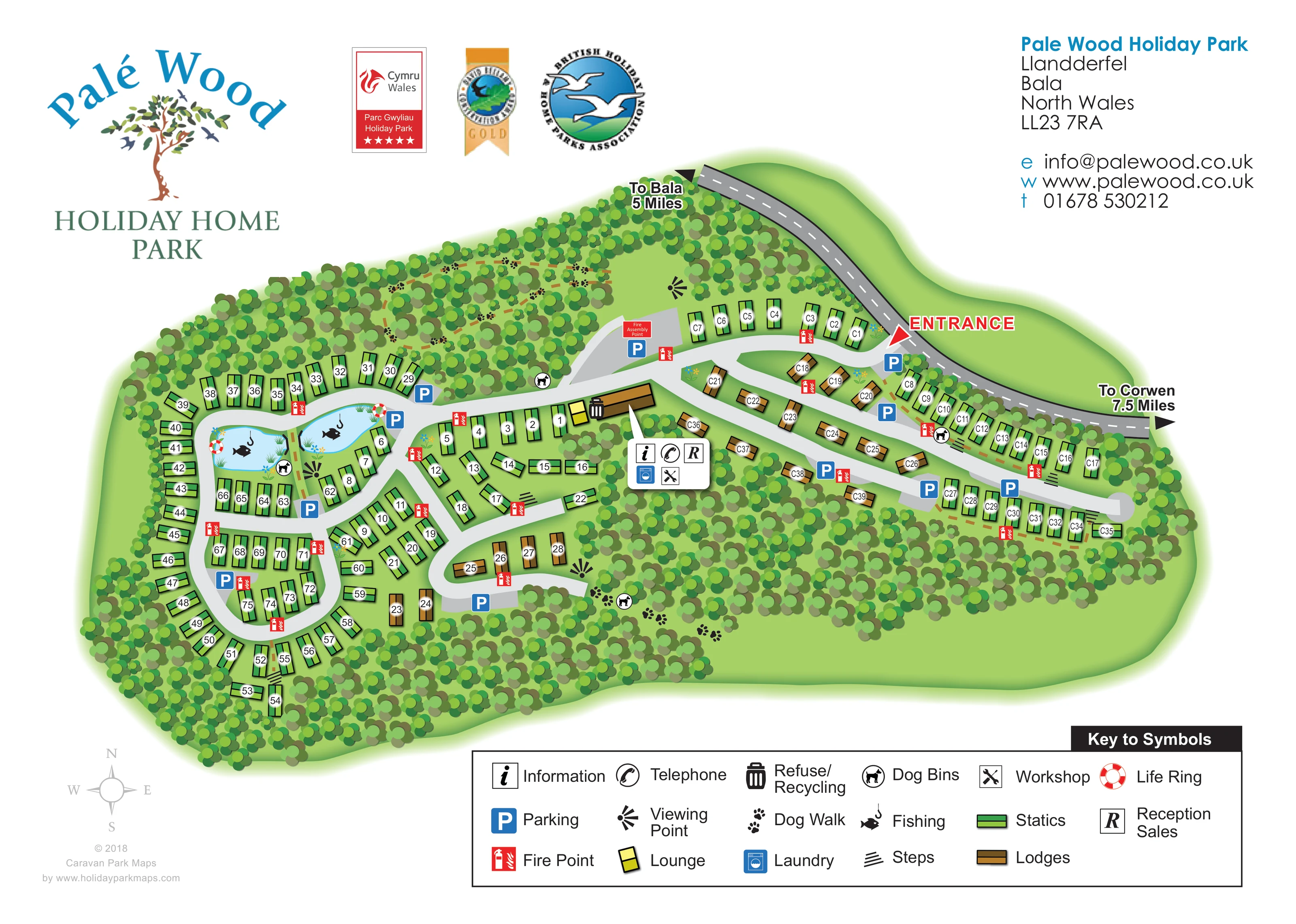
Two blue ponds in the western accommodation area carry fish-and-hook symbols and illustrated marginal planting.
ILLUSTRATED PARK MAP · P562
Pale Wood Holiday Park, Llandderfel, Bala, North Wales · United Kingdom
 Enlarge the map ↗
A SENSE OF THE PLACE
Palé Wood Holiday Park is set in private woodland near Llandderfel and Bala. Views across the Dee Valley and towards Eryri provide the backdrop to caravan and lodge ownership.
Walking routes and wildlife are part of the park's appeal. The map explains the arrangement of holiday homes and internal roads within the wooded grounds, helping owners and visitors understand the site.
LOOK CLOSER
Two blue ponds in the western accommodation area carry fish-and-hook symbols and illustrated marginal planting.
Dense clusters of stylised tree crowns surround the park, separate accommodation groups and occupy broad internal woodland areas.
Black fan-shaped viewpoint symbols are placed in the northern clearing, near the ponds and beside the southern woodland.
A red arrow and large ENTRANCE label identify the connection from the public road at the upper-right side of the park.
The curved grey public road carries directional arrows towards Bala and Corwen, providing regional orientation.
Light-grey roads connect a compact western loop network with elongated eastern branches and rounded turning ends.
The reception and sales symbol appears in a grouped service callout beside the central building.
An information symbol is included in the central service callout.
A red arrow and large ENTRANCE label identify the connection from the public road at the upper-right side of the park.
The curved grey public road carries directional arrows towards Bala and Corwen, providing regional orientation.
Light-grey roads connect a compact western loop network with elongated eastern branches and rounded turning ends.
The reception and sales symbol appears in a grouped service callout beside the central building.
An information symbol is included in the central service callout.
A telephone symbol is grouped with the central reception and service facilities.
A blue washing-machine symbol identifies laundry in the central service callout.
Crossed tools identify a workshop within the central service group.
A yellow lounge symbol sits immediately beside the long central building.
Blue P symbols mark parking locations near the entrance, central junctions, ponds and accommodation roads.
A black bin symbol marks refuse and recycling beside the central building.
Red fire-point symbols are distributed throughout the accommodation areas. A separately labelled fire assembly point is shown beside parking on the northern approach.
Two blue ponds in the western accommodation area carry fish-and-hook symbols and illustrated marginal planting.
Red-and-white life-ring symbols are positioned at the two ponds.
Dense clusters of stylised tree crowns surround the park, separate accommodation groups and occupy broad internal woodland areas.
Paw-print markers identify dog-walking routes through the northern and southern woodland.
Dog-bin symbols appear near the ponds, woodland routes and eastern accommodation roads.
Black fan-shaped viewpoint symbols are placed in the northern clearing, near the ponds and beside the southern woodland.
Short sets of black parallel strokes mark steps between selected accommodation rows and connecting areas.
The park context places the wooded grounds near Llandderfel and Bala, with views across the Dee Valley and towards Eryri; these wider landscapes are not illustrated in the plan.
READING THE MAP
This illustrated map of Palé Wood Holiday Park presents a woodland holiday home setting near Llandderfel and Bala in North Wales. Dense green tree canopies surround the accommodation and divide the grounds into recognisable areas, while pale-grey roads make the routes through the park easy to follow. The plan distinguishes static caravans from lodges with green and brown symbols, supported by individual plot labels.
The western part of the map is organised around winding road loops and two fishing ponds. To the east, longer branches serve rows of holiday homes and smaller lodge groups. Between them, a central building and compact service callout identify reception and sales, information, telephone, laundry and workshop facilities, with the lounge highlighted separately.
Practical details sit alongside the landscape illustration: parking places, fire points, dog bins, woodland dog walks and viewing points all have clear symbols. A prominent entrance arrow connects the site to the road towards Bala and Corwen. The result is a sample suited to holiday home parks that need to explain both their accommodation layout and the character of wooded grounds.
The plan uses an overhead layout to show an elongated park enclosed by woodland. Arrival is marked on the upper-right edge, where a red entrance arrow leads from a darker public road into the light-grey internal network. Directional labels towards Bala and Corwen provide context beyond the park boundary.
From the entrance, the eastern section spreads along gently curving branches. Green static caravan symbols line the outer roads, while brown lodges occupy shorter groups nearer the centre. Parking symbols punctuate the roads, and rounded ends make the branch structure clear. The western section has a denser arrangement of loops, with accommodation following the curves and filling smaller internal rows. A short southern loop contains another cluster of lodges.
Two irregular blue fishing ponds provide distinctive landmarks within the western area. Reeds, small flowers, fishing symbols and life rings give them both visual character and practical meaning. Nearby dog bins and viewpoint markers connect this part of the plan with the wider woodland setting. Paw-print trails continue through trees along the northern and southern grounds, while step symbols identify selected connections between rows.
A long brown building sits near the meeting point of the two accommodation areas. A white callout groups information, telephone, reception and sales, laundry and workshop symbols; the yellow lounge marker and refuse/recycling symbol sit beside the building. Red fire-point symbols recur across the site, with a labelled assembly point on the northern approach.
The single landscape-format artwork is framed by the large Palé Wood logo, award and association emblems, a contact block, compass rose and comprehensive symbol key. The accompanying detail views enlarge parts of this same sheet rather than showing separate park sections.
KEEP EXPLORING
Chosen for shared landscapes, accommodation or facilities.
 Explore the map ↗
United Kingdom
A woodland estate park map combining caravan loops, touring pitches, riverside paths and Bruce’s Cave landmarks.
 Explore the map ↗
United Kingdom
Trevornick’s colour-coded park map, with mixed accommodation, fishing ponds, golf and wooded trails.
 Explore the map ↗
United Kingdom
Woodland-framed Barnsoul map with mixed accommodation, shared facilities and paw-marked walking routes.
Features may come from the sample artwork, its key or published park information. Approximate numbers describe the drawing and may cover only part of a park. They are intended to help you compare map examples. Current facilities and booking information should be checked with the park.
TAKE A CLOSER LOOK
View the illustrated map in detail or choose a file to download. These are sample maps; contact the park for current visitor information.
LET’S MAP YOUR PARK
For a map quotation, find your park and draw a rough boundary around it. The area you select helps us work out the design time and price.
Draw your park for a quote ↗Or talk to our map designers
01751 473136