
Wildlife pond
A blue pond with a small green island, reeds and a dragonfly illustration sits within the north-eastern woodland.
ILLUSTRATED PARK MAP · P244
Parkgate Farm, Irton, Holmrook, Cumbria · United Kingdom
 Enlarge the map ↗
A SENSE OF THE PLACE
Parkgate Farm offers camping and self-catering holidays near Irton, with views towards the Wasdale and Eskdale fells. Cabins, holiday caravans and a cottage complement the camping spaces.
Fields and woodland surround the accommodation, with walking, cycling and riding routes accessible nearby. Some camping pitches have electricity, and grazing can be arranged for visiting horses. The map helps explain the farm's varied accommodation layout.
LOOK CLOSER
A blue pond with a small green island, reeds and a dragonfly illustration sits within the north-eastern woodland.
Dense groups of varied tree symbols surround the accommodation, entrance and pond, with smaller planted clusters dividing spaces.
Open grassland occupies the southern area. Orange fences divide paddock-like enclosures, while strings of grey stones mark other boundaries and green hatching suggests banks.
A wooden-style ENTRANCE sign and red pointer identify arrival from the left-hand edge.
Broad white lanes curve into the site and branch towards the camping area, cabins, farmyard and holiday-caravan row.
A dashed brown route with black footprints runs through the northern trees and around the wildlife pond.
An information symbol marks a small orange-roofed building at the central lane junction.
A grouped symbol panel locates these facilities beside the central service area below the farmyard.
A wooden-style ENTRANCE sign and red pointer identify arrival from the left-hand edge.
Broad white lanes curve into the site and branch towards the camping area, cabins, farmyard and holiday-caravan row.
A dashed brown route with black footprints runs through the northern trees and around the wildlife pond.
An information symbol marks a small orange-roofed building at the central lane junction.
A grouped symbol panel locates these facilities beside the central service area below the farmyard.
A blue tap symbol marks a water point near the camping-side service junction.
Paired waste and recycling symbols appear near the central facilities and at the upper end of the holiday-caravan row.
A yellow disposal symbol is positioned beside the information building.
Red fire-point symbols are shown at the central service junction and beside the ball-games area.
Yellow lightning symbols distinguish some camping pitches and appear beside the pod.
Black barbecue icons accompany the three cabins; picnic tables are drawn beside cabins, holiday caravans and the cottage.
A labelled grass area lies between the cabin cluster and holiday-caravan lane.
A blue pond with a small green island, reeds and a dragonfly illustration sits within the north-eastern woodland.
Dense groups of varied tree symbols surround the accommodation, entrance and pond, with smaller planted clusters dividing spaces.
Open grassland occupies the southern area. Orange fences divide paddock-like enclosures, while strings of grey stones mark other boundaries and green hatching suggests banks.
Named farm buildings form a grey-roofed cluster around a hardstanding yard north of the visitor facilities; the map does not identify the barn as guest accommodation.
Red-ringed markers displaying 10 and 5 appear on different sections of the internal route.
Small car illustrations indicate vehicle spaces alongside the caravan lane and near Harter Cottage, without a separately labelled car park.
READING THE MAP
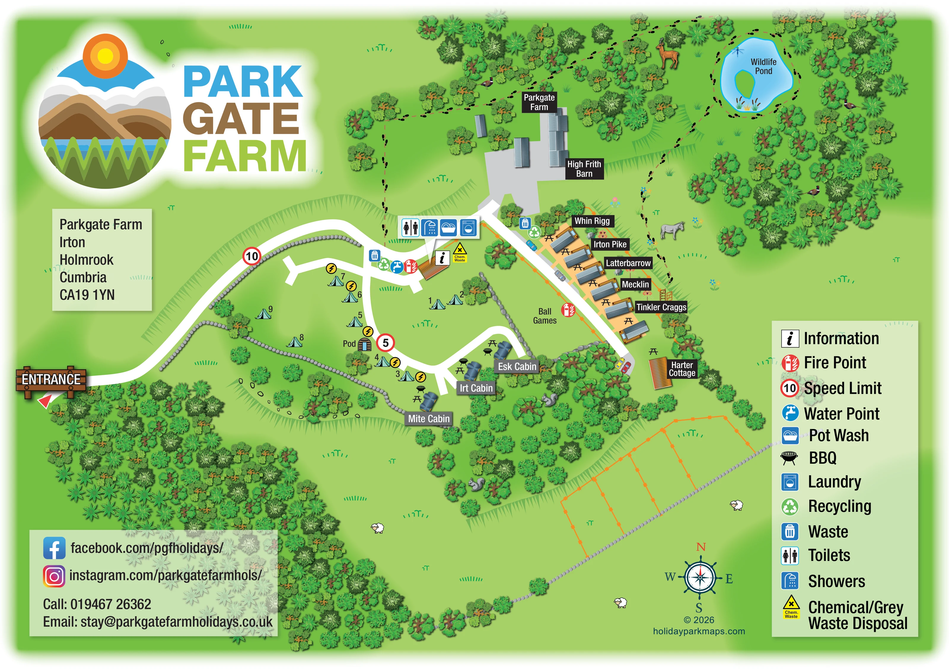
This illustrated map of Parkgate Farm in Irton, near Holmrook in Cumbria, brings together a small camping area, holiday caravans, cabins, a pod and a cottage within a wooded farm setting. Rather than presenting the site as a uniform grid, the artwork follows its curving entrance lane, branching access routes and distinct accommodation groups. Named buildings and numbered camping pitches give visitors practical reference points, while a prominent legend explains the everyday facilities.
The landscape is an important part of the composition. Dense tree clusters frame the entrance and accommodation, stone boundaries divide the grass areas, and a footprint-marked walking route leads towards a wildlife pond in the upper-right corner. Small animal illustrations add a farm and woodland character without competing with the principal labels.
A large landscape-themed logo, address panel and contact block make the sheet recognisably Parkgate Farm. This sample is particularly relevant to smaller rural holiday sites that need one map to explain several accommodation types, shared facilities and quieter outdoor spaces.
The single landscape-format plan places the entrance at the left-hand edge, marked by an illustrated wooden sign and red pointer. A broad white lane curves towards the centre, where information, water, waste, recycling and fire-point symbols gather around a small building. A separate callout identifies toilets, showers, pot wash and laundry beside the route towards the farmyard; chemical and grey waste disposal is marked nearby.
The camping area spreads across the central-left grass, with numbered tent symbols and yellow electricity markers beside some pitches. Grey stone boundaries help describe its irregular shape. A barrel-shaped pod sits beside an internal junction, while Mite, Irt and Esk cabins occupy a smaller cluster to the south. Each cabin is accompanied by picnic-table and barbecue illustrations.
To the east, a diagonal access lane serves a short row of holiday caravans. Ribbed grey roofs, orange decks, picnic tables and individual name labels make this accommodation visibly different from the cabins. Harter Cottage stands separately towards the end of the lane, and a labelled ball-games area occupies grass between the two accommodation groups. Parkgate Farm and High Frith Barn anchor the northern building cluster.
Beyond the buildings, a dashed walking line with repeated footprints passes through trees and circles the wildlife pond. Open fields, orange-fenced enclosures, bank hatching and scattered animal illustrations extend the rural setting across the lower half of the page. A compass rose supports orientation, while the tall right-hand legend keeps service symbols easy to interpret. The large logo and two pale-green information panels balance the detailed plan without requiring a separate inset.
KEEP EXPLORING
Chosen for shared landscapes, accommodation or facilities.
 Explore the map ↗
United Kingdom
Woodland-framed Barnsoul map with mixed accommodation, shared facilities and paw-marked walking routes.
 Explore the map ↗
United Kingdom
A colour-zoned coastal park map with touring areas, woodland trails, ponds and a leisure club.
 Explore the map ↗
United Kingdom
Woodland holiday-park map with named accommodation areas, touring loops and illustrated recreation facilities.
Features may come from the sample artwork, its key or published park information. Approximate numbers describe the drawing and may cover only part of a park. They are intended to help you compare map examples. Current facilities and booking information should be checked with the park.
TAKE A CLOSER LOOK
View the illustrated map in detail or choose a file to download. These are sample maps; contact the park for current visitor information.

LET’S MAP YOUR PARK
For a map quotation, find your park and draw a rough boundary around it. The area you select helps us work out the design time and price.
Draw your park for a quote ↗Or talk to our map designers
01751 473136