
Fishing pond and coarse fishery
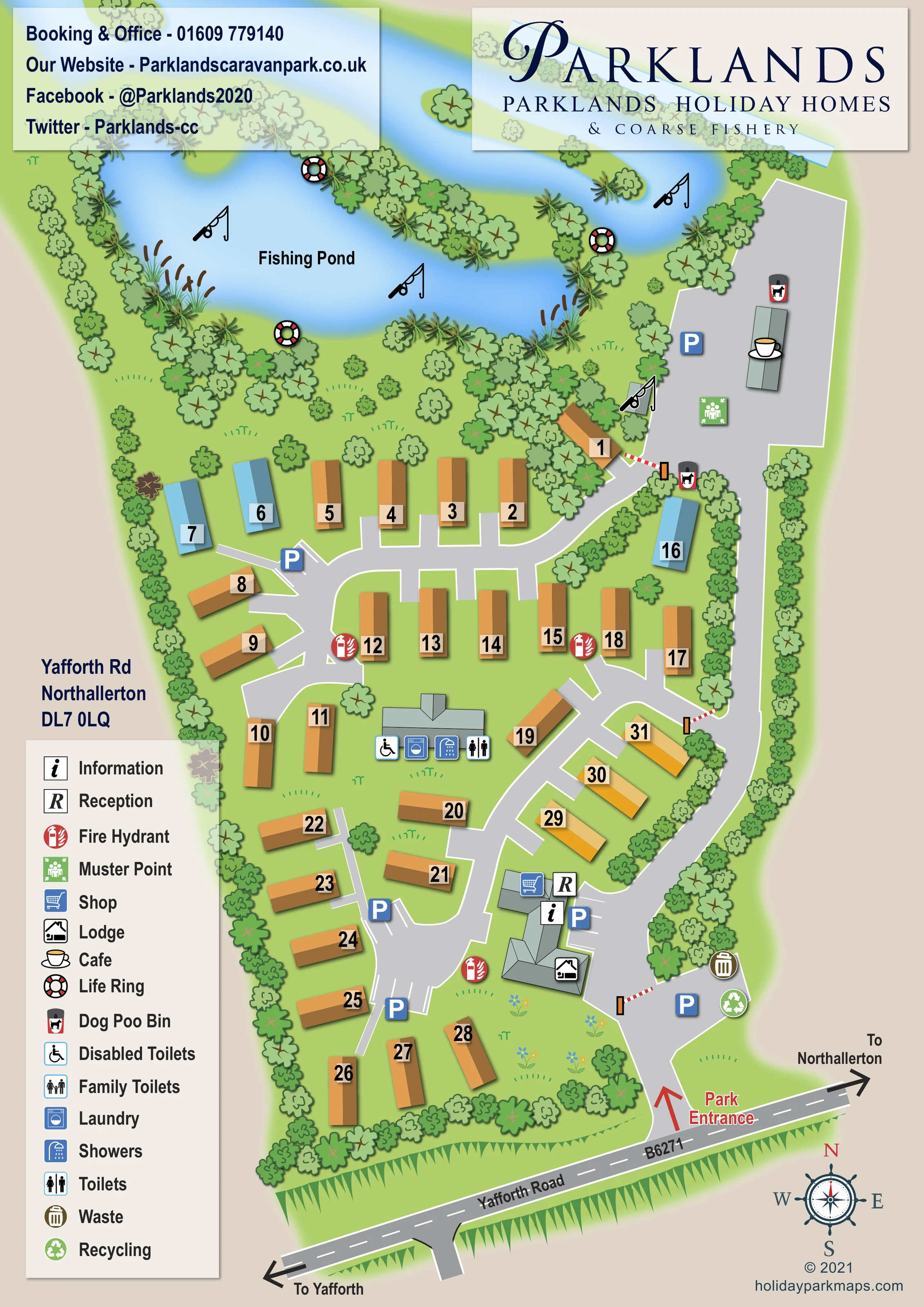
A large, irregular blue water feature occupies the upper part of the page, labelled Fishing Pond and reinforced by fishing-rod pictograms and the coarse-fishery branding.
ILLUSTRATED PARK MAP · P564
Yafforth Rd, Northallerton · United Kingdom
 Enlarge the map ↗
A SENSE OF THE PLACE
Parklands Caravan Park is a family-run site near Northallerton in North Yorkshire. Lodges overlook private fishing lakes, with touring pitches also available.
An on-site café, Wi-Fi and modern washrooms support visits. Fishing is a prominent feature of the park, and the map shows how the touring and holiday home areas relate to the lakes and shared facilities.
LOOK CLOSER
A large, irregular blue water feature occupies the upper part of the page, labelled Fishing Pond and reinforced by fishing-rod pictograms and the coarse-fishery branding.
Dense illustrated trees, shrubs and reeds surround the pond and follow its projecting banks.
Green lawns, scattered trees, small flower motifs and continuous boundary planting frame the holiday homes and separate the eastern approach road from the accommodation.
Reception and information symbols sit on the shared building group just inside the entrance, beside parking.
A shopping-trolley symbol marks the shop within the entrance-side building group.
A cup-and-saucer symbol identifies a separate building on the broad paved area beside the pond, reached by the eastern approach road.
A central service building carries toilets, showers and wheelchair-marked toilet symbols. The legend calls the latter Disabled Toilets; the map does not establish wider accessibility provision.
A washing-machine symbol marks laundry facilities at the central washroom building.
A large, irregular blue water feature occupies the upper part of the page, labelled Fishing Pond and reinforced by fishing-rod pictograms and the coarse-fishery branding.
Dense illustrated trees, shrubs and reeds surround the pond and follow its projecting banks.
Green lawns, scattered trees, small flower motifs and continuous boundary planting frame the holiday homes and separate the eastern approach road from the accommodation.
Reception and information symbols sit on the shared building group just inside the entrance, beside parking.
A shopping-trolley symbol marks the shop within the entrance-side building group.
A cup-and-saucer symbol identifies a separate building on the broad paved area beside the pond, reached by the eastern approach road.
A central service building carries toilets, showers and wheelchair-marked toilet symbols. The legend calls the latter Disabled Toilets; the map does not establish wider accessibility provision.
A washing-machine symbol marks laundry facilities at the central washroom building.
Family Toilets appears in the legend, but a corresponding location is not clearly marked on the plan.
Blue P symbols identify parking near reception, the entrance, several accommodation-road branches and the pond-side café. Some spaces are also drawn with white bay lines.
Waste-bin and recycling symbols are grouped on the entrance-side paved area.
Dog waste-bin symbols are shown around the upper approach and café area.
Repeated red fire-hydrant symbols are distributed through the accommodation grounds.
A green assembly symbol marks a muster point on the paved area beside the café.
Life-ring symbols appear at several points around the fishing pond.
A red arrow and Park Entrance label identify the southern access from Yafforth Road, marked B6271.
An eastern approach road leads towards the café and pond, while curved branches serve the holiday homes. Red-and-white barrier arms distinguish several internal access points.
Large black arrows at the ends of the frontage road indicate Yafforth to the left and Northallerton to the right. A compass rose provides orientation.
READING THE MAP
This illustrated map of Parklands Holiday Homes near Northallerton brings together a compact holiday-home layout and a prominent coarse-fishing setting. The pond fills the upper part of the portrait page, surrounded by trees, reeds and planted banks, while roughly 30 numbered holiday homes occupy the landscaped grounds below. Fishing-rod pictograms and life-ring symbols give the water a clear role in the visitor experience rather than treating it as background scenery.
Arrival is shown from Yafforth Road, with reception, information, the shop and parking grouped close to the entrance. A separate approach continues along the eastern edge to the pond-side café, while branching roads serve the accommodation and central washroom building. The combination of numbered roofs, blue parking markers and a tall facility legend helps visitors move between these different parts of the site.
Warm roof colours, soft blue water and layered green planting give the plan its character. Large branding panels above the map and a decorative compass below complete a practical, distinctly waterside holiday-park design.
The map is organised around a strong entrance-to-pond sequence. Yafforth Road, labelled B6271, runs diagonally across the bottom, with arrows towards Yafforth and Northallerton. A red entrance arrow draws attention to the access road, which passes the reception and shop building group before continuing along the tree-lined eastern side of the park. Parking, waste and recycling symbols make the arrival area easy to recognise, and red-and-white barrier arms mark connections into the internal road network.
Within the accommodation grounds, curving lanes and short spurs serve rows and angled groups of numbered holiday homes. The units are drawn as shaded rectangular roofs, mostly ochre with a few blue and yellow variations. Large black numbers on pale tabs provide the primary accommodation reference. Near the centre, a separate building is marked for toilets, showers, accessible toilets and laundry. The legend also includes family toilets, although their position is not clearly identified on the plan.
Above the homes, the irregular fishing pond is framed by dense illustrated planting, reeds and projecting banks. Rod symbols reinforce its purpose, while life-ring markers identify waterside equipment. The café occupies a separate paved area beside the pond, accompanied by parking, a muster point and dog waste-bin symbols. Fire-hydrant markers are distributed through the accommodation area.
The single portrait artwork combines the site plan, legend, address, contact panel and large Parklands Holiday Homes & Coarse Fishery branding. A compass rose balances the lower-right margin. Shaded roofs and tree crowns add depth to an essentially overhead view, while broad grey roads and white edges preserve a readable route structure.
KEEP EXPLORING
Chosen for shared landscapes, accommodation or facilities.
 Explore the map ↗
United Kingdom
Colour-coded accommodation, central leisure facilities and coastal paths on an illustrated headland park map.
 Explore the map ↗
United Kingdom
A woodland estate park map combining caravan loops, touring pitches, riverside paths and Bruce’s Cave landmarks.
 Explore the map ↗
United Kingdom
Trevornick’s colour-coded park map, with mixed accommodation, fishing ponds, golf and wooded trails.
Features may come from the sample artwork, its key or published park information. Approximate numbers describe the drawing and may cover only part of a park. They are intended to help you compare map examples. Current facilities and booking information should be checked with the park.
LET’S MAP YOUR PARK
For a map quotation, find your park and draw a rough boundary around it. The area you select helps us work out the design time and price.
Draw your park for a quote ↗Or talk to our map designers
01751 473136