
Alpaca Fields
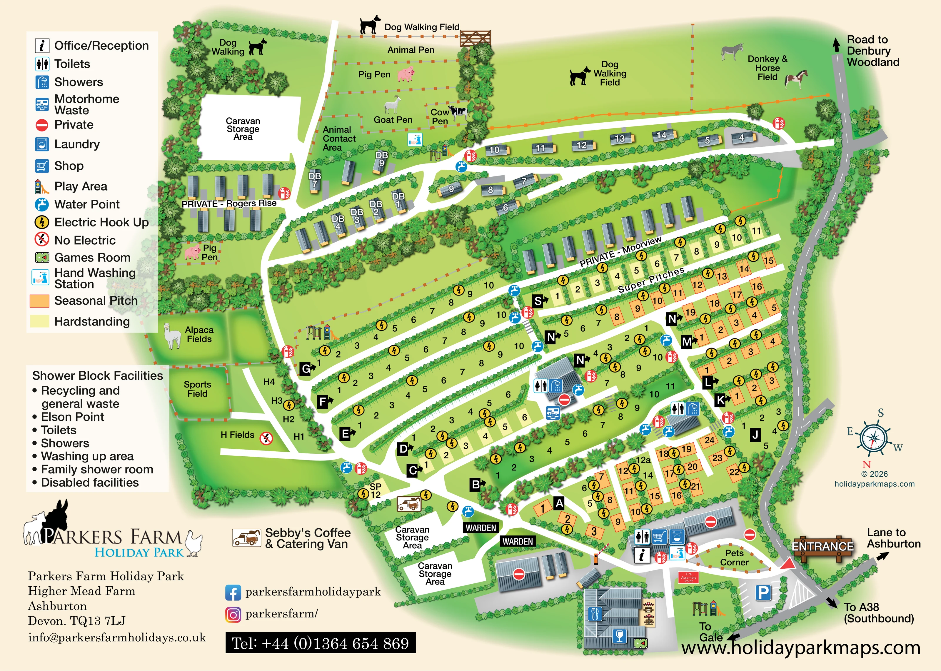
Fenced pasture illustrated with an alpaca lies along the left side of the park.
ILLUSTRATED PARK MAP · P243
Parkers Farm Holiday Park, Higher Mead Farm, Ashburton, Devon · United Kingdom
 Enlarge the map ↗
A SENSE OF THE PLACE
Parkers Farm Holiday Park is a countryside base near Ashburton in South Devon. It welcomes touring caravans, motorhomes and campers, and also offers static caravan accommodation.
Dog-walking spaces are among the features described by the park. Its position suits outings into Dartmoor and the surrounding towns and countryside, while the map gives visitors an overview of the different accommodation areas.
LOOK CLOSER
Fenced pasture illustrated with an alpaca lies along the left side of the park.
A large upper-right pasture is labelled and illustrated with donkey and horse figures.
Several labelled dog-walking spaces run across the upper edge, including a tree-lined area at the left and a broad fenced field towards the right.
Dense illustrated planting frames the park, separates caravan areas and divides the long pitch rows; fenced pasture gives the upper and left edges a farm character.
Information symbol on the entrance-side service building, close to Pets Corner and the main arrival junction.
Shop and washing-machine symbols share the entrance-side building with reception and toilets.
Toilets are shown near reception, with two further toilet-and-shower buildings within the pitch layout.
A separate panel lists recycling and general waste, an Elson point, toilets, showers, washing-up area, family shower room and disabled facilities. These are grouped services rather than individually plotted locations.
Information symbol on the entrance-side service building, close to Pets Corner and the main arrival junction.
Shop and washing-machine symbols share the entrance-side building with reception and toilets.
Toilets are shown near reception, with two further toilet-and-shower buildings within the pitch layout.
A separate panel lists recycling and general waste, an Elson point, toilets, showers, washing-up area, family shower room and disabled facilities. These are grouped services rather than individually plotted locations.
A dedicated waste symbol is positioned beside the larger central shower building.
Blue tap symbols recur at lane junctions and service buildings; yellow lightning symbols identify electric provision throughout much of the pitch area.
Hand-washing symbols appear beside the upper animal contact area and near the entrance-side Pets Corner.
Illustrated swings and slides mark play spaces near the entrance, beside the upper animal area and at the western end of the touring rows.
A fenced green field sits beside the H Fields and below the Alpaca Fields.
The legend's games-room symbol is repeated on the larger building below the reception area.
Cutlery and drinking-glass symbols identify food and drink functions in the entrance-side building complex, with illustrated outdoor picnic tables.
A named coffee-and-catering van symbol is placed near the lower caravan storage areas and the SP pitch.
A fenced enclosure immediately inside the entrance, beside reception and a hand-washing station.
The upper farm area includes an Animal Contact Area, an Animal Pen, Goat Pen, Cow Pen and Pig Pen; a further Pig Pen is shown beside Rogers Rise.
Fenced pasture illustrated with an alpaca lies along the left side of the park.
A large upper-right pasture is labelled and illustrated with donkey and horse figures.
Several labelled dog-walking spaces run across the upper edge, including a tree-lined area at the left and a broad fenced field towards the right.
Dense illustrated planting frames the park, separates caravan areas and divides the long pitch rows; fenced pasture gives the upper and left edges a farm character.
Several clearly labelled storage areas appear at the upper left and near the lower internal junctions. They are distinct from accommodation pitches.
Two WARDEN labels appear near the lower lanes. Rogers Rise and Moorview are explicitly private, with further private symbols on service-side buildings and access points.
A blue P symbol and marked parking bays sit just inside the entrance.
Red extinguisher symbols recur around the plan, and a labelled Fire Assembly Point is shown near entrance parking.
A prominent timber-style entrance sign marks arrival from the grey boundary road. White internal lanes branch into the pitch rows, caravan areas and farm spaces; a barrier is illustrated near the lower service area.
Arrows indicate the lane to Ashburton, the A38 southbound, Gale and the road to Denbury Woodland. Denbury Woodland is an off-map destination, not a mapped woodland facility.
The Super Pitches row is named, pale-yellow plots indicate hardstanding, orange plots indicate seasonal use, and the H Fields carry a no-electric symbol.
READING THE MAP
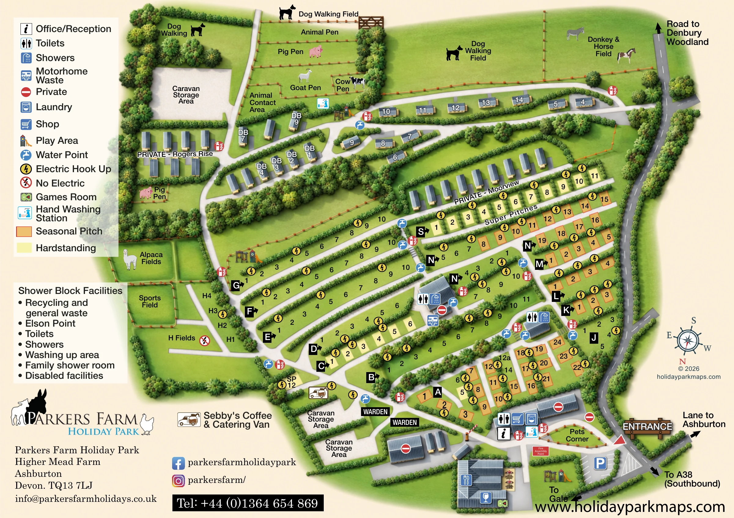
This illustrated map of Parkers Farm Holiday Park brings a working-farm setting and a substantial holiday-park layout together on one landscape-format page. Based at Higher Mead Farm near Ashburton in Devon, the park is shown through its touring rows, caravan areas, visitor facilities and surrounding animal fields.
The centre of the artwork is organised around long, hedge-lined pitch rows, with bold section letters and individual numbers providing the practical framework. Pale-yellow hardstandings, orange seasonal spaces and electric hook-up symbols distinguish different pitch characteristics without obscuring the routes. Above these rows, illustrated caravans follow separate lanes, including the clearly marked private Rogers Rise and Moorview areas.
The farm character is especially prominent: alpacas, pigs, goats, cows, donkeys and horses help identify the surrounding enclosures, alongside an animal contact area and Pets Corner. Dog-walking spaces, play areas and a sports field extend the visitor picture beyond accommodation. A large symbol key and a separate shower-block information panel make this a useful example of a map that combines detailed arrival guidance with a distinctive countryside identity.
The map is arranged around an entrance at the lower right, reached from a grey road running along the park boundary. Direction arrows point towards Ashburton, the A38 southbound, Gale and Denbury Woodland. Just inside the entrance, parking bays, a fire assembly point, Pets Corner and the reception-side building form a compact arrival hub. Symbols identify the office, shop, laundry and toilets, while a neighbouring building carries food, drink and games-room symbols beside illustrated outdoor tables.
White lanes lead into the accommodation areas, branching between long diagonal rows of numbered pitches. Large black section markers make the rows easy to distinguish. The artwork separately identifies hardstanding, seasonal pitches and electric hook-ups, with a named Super Pitches row towards the upper right. The H Fields occupy a more open area on the left and include a no-electric symbol. Two shower buildings sit among the pitches, with repeated water and fire-point symbols nearby; a motorhome waste point is shown beside the larger block.
Caravan accommodation follows hedge-lined lanes above the touring area. Rogers Rise and Moorview are marked private, while caravan storage areas and warden labels remain distinct from visitor pitches. Sebby's Coffee & Catering Van is marked near the lower storage areas.
Around the perimeter, labelled dog-walking spaces and animal enclosures give the plan its farm identity. These include Alpaca Fields, a Donkey and Horse Field, pig, goat and cow pens, and an Animal Contact Area with a hand-washing station. Play equipment appears in several locations, and a sports field adjoins the H Fields. The single-sheet composition uses a left-hand legend, a separate shower-services panel, park branding and a compass with north towards the bottom of the page.
 Enlarge this map ↗
KEEP EXPLORING
Chosen for shared landscapes, accommodation or facilities.
 Explore the map ↗
United Kingdom
Colour-coded pitches, a leafy facilities hub and a long static-caravan wing at Haw Wood Farm, Suffolk.
 Explore the map ↗
United Kingdom
Mixed-accommodation park map with woodland, public footpaths and clearly differentiated service symbols.
 Explore the map ↗
United Kingdom
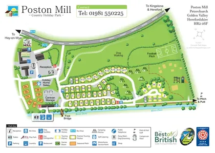
Riverside touring-park map with colour-coded pitches, dog-walking grounds and illustrated visitor facilities.
Features may come from the sample artwork, its key or published park information. Approximate numbers describe the drawing and may cover only part of a park. They are intended to help you compare map examples. Current facilities and booking information should be checked with the park.
LET’S MAP YOUR PARK
For a map quotation, find your park and draw a rough boundary around it. The area you select helps us work out the design time and price.
Draw your park for a quote ↗Or talk to our map designers
01751 473136