
Grassy paddocks and planted boundaries
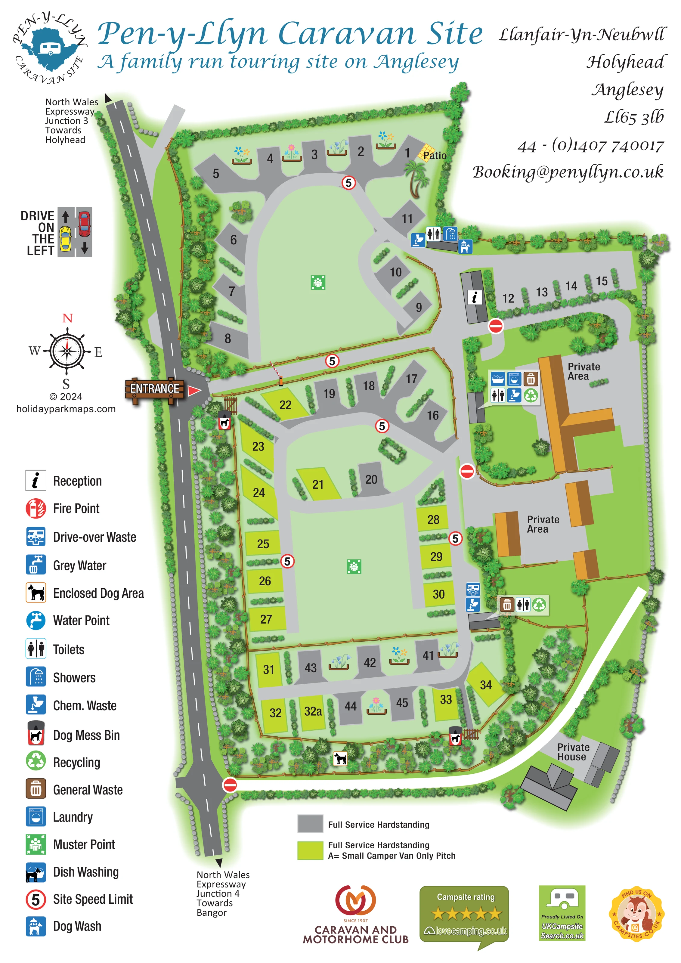
Large pale-green open centres are framed by pitch loops, hedges, individual shrubs, flower planters and dense perimeter planting.
ILLUSTRATED PARK MAP · P248
Llanfair-Yn-Neubwll, Holyhead, Anglesey · United Kingdom
 Enlarge the map ↗
A SENSE OF THE PLACE
Pen-y-Llyn is an adults-only Caravan and Motorhome Club Certificated Location on Anglesey. Its small south-facing paddock has level hardstandings with water, grey-water and electric connections.
The site welcomes pets and provides a base near the Valley Wetlands reserve and Anglesey Coast Path. Coastal walks and the beaches around Cymyran and Rhosneigr are part of the surrounding area's appeal.
LOOK CLOSER
Large pale-green open centres are framed by pitch loops, hedges, individual shrubs, flower planters and dense perimeter planting.
An information symbol marks a narrow building beside the northern arrival area and an adjoining row of pitches.
Toilet symbols appear at several service clusters; showers are marked at the northern facility building.
Laundry and washing-up symbols are grouped with toilets, chemical waste and bins beside the central eastern service building.
Chemical waste symbols are distributed between the northern, central and southern service areas.
A drive-over waste symbol marks the service area beside the eastern lane near the southern pitch group.
General waste and recycling symbols are grouped at the central and southern service points.
A dog symbol identifies a fenced, planted strip along the southern boundary, with gates connecting it to the pitch area.
An information symbol marks a narrow building beside the northern arrival area and an adjoining row of pitches.
Toilet symbols appear at several service clusters; showers are marked at the northern facility building.
Laundry and washing-up symbols are grouped with toilets, chemical waste and bins beside the central eastern service building.
Chemical waste symbols are distributed between the northern, central and southern service areas.
A drive-over waste symbol marks the service area beside the eastern lane near the southern pitch group.
General waste and recycling symbols are grouped at the central and southern service points.
A dog symbol identifies a fenced, planted strip along the southern boundary, with gates connecting it to the pitch area.
A dog-wash symbol appears beside the northern toilet and shower building.
Dog waste bins are shown near the entrance-side gate and the southern gate into the enclosed dog area.
Green assembly symbols mark the open centres of the northern and central grassy paddocks.
A small orange tiled area labelled Patio sits beside a pitch at the north-eastern corner.
Included in the facility key; a corresponding position is not clearly identifiable on the plan.
A standalone water-point symbol is defined in the key, without a clearly identifiable matching location in the plan.
The key includes a separate grey-water symbol; the plan clearly locates drive-over and chemical waste facilities but not this specific symbol.
Large pale-green open centres are framed by pitch loops, hedges, individual shrubs, flower planters and dense perimeter planting.
A timber-style entrance sign and red pointer mark the western access from the adjoining road; a barrier is illustrated on the internal arrival drive.
The road is annotated towards Junction 3 and Holyhead at the top, and Junction 4 and Bangor at the bottom.
Repeated red-ringed 5 signs, no-entry symbols, a drive-on-the-left diagram and a compass rose form part of the visitor guidance shown in the artwork.
Eastern yards and buildings are labelled Private Area, with a Private House at the south-eastern edge and a separate curved approach.
READING THE MAP
This illustrated map of Pen-y-Llyn Caravan Site presents a landscaped touring site at Llanfair-yn-Neubwll, near Holyhead on Anglesey. Its portrait format brings together numbered hardstanding pitches, arrival routes, practical service points and private areas in one visitor-facing plan. Rather than drawing individual caravans, the artwork uses clear pitch shapes and large numbers, keeping the accommodation layout easy to scan.
The map shows roughly 40 pitches grouped around open grassy paddocks and short rows, with hedges, fences and planting separating the different areas. A prominent entrance sign leads the eye from the adjoining road into the site, while reception and facility symbols identify useful destinations along the internal lanes. An enclosed dog area occupies the planted southern boundary, and a dog wash is marked beside the northern facilities.
Teal branding, a detailed left-hand key and colourful service icons give the page a recognisable hierarchy. The result is a useful sample for touring-site owners who need to explain pitch locations, vehicle access and dispersed facilities without losing the character of a green, carefully landscaped setting.
The main plan runs vertically beside a dark-grey road on its western edge. Approach labels refer to the North Wales Expressway towards Holyhead and Bangor, while a compass and a separate drive-on-the-left graphic provide orientation. A timber-style ENTRANCE sign points into a fenced arrival drive, with an illustrated barrier before the route reaches the eastern side of the site.
North of this drive, a curved lane serves pitches around a large grassy centre. Flower planters decorate the upper row, and a small patio is labelled at the north-eastern corner. A nearby facility building carries toilet, shower, chemical-waste and dog-wash symbols. Reception stands farther east beside a short row of hardstandings.
The central touring area combines a loop at its upper end with pitches down both sides of another broad green space. Its eastern lane passes service clusters containing laundry, dish washing, toilets, chemical waste, general waste and recycling. Farther south, drive-over waste disposal is marked beside another small service building. Two compact rows complete the southern accommodation group. Both grey and lime pitch fills are described as full-service hardstanding, with an A suffix identifying a small-campervan-only pitch.
Dense planting and timber fences define the paddocks, private yards and enclosed dog area along the bottom boundary. A separate white approach curves towards the private house at the south-east. The page combines this detailed plan with a tall facility legend, a smaller pitch key, contact information and club and directory badges. The enlarged quadrant views show details of this same single-page design, rather than additional sections or separate maps.
KEEP EXPLORING
Chosen for shared landscapes, accommodation or facilities.
 Explore the map ↗
United Kingdom
Illustrated Sanday aire map with a seasonal maze, café barn and motorhome service area.
 Explore the map ↗
United Kingdom
A woodland touring-park map with colour-coded pitches, a stream and footprint-marked walks.
 Explore the map ↗
United Kingdom
Colour-coded campsite map with riverside pitches, bell tents, a swimming pool and fishing lake.
Features may come from the sample artwork, its key or published park information. Approximate numbers describe the drawing and may cover only part of a park. They are intended to help you compare map examples. Current facilities and booking information should be checked with the park.
LET’S MAP YOUR PARK
For a map quotation, find your park and draw a rough boundary around it. The area you select helps us work out the design time and price.
Draw your park for a quote ↗Or talk to our map designers
01751 473136