
Tree and hedge boundaries
Dense illustrated planting encloses the park, borders the public road and separates several accommodation rows.
ILLUSTRATED PARK MAP · P249
Penisar Mynydd Caravan Park, Caerwys Road, Rhuallt, St Asaph, Denbighshire · United Kingdom
 Enlarge the map ↗
A SENSE OF THE PLACE
Penisar Mynydd is a family-run touring and camping park at Rhuallt near St Asaph. Its rural setting offers views towards the Clwydian Range, with the North Wales coast nearby.
Hardstanding caravan pitches provide drainage and selected water connections, while a separate grass field accommodates tents. Local walking routes and trips to Rhyl and Prestatyn offer options beyond the park.
LOOK CLOSER
Dense illustrated planting encloses the park, borders the public road and separates several accommodation rows.
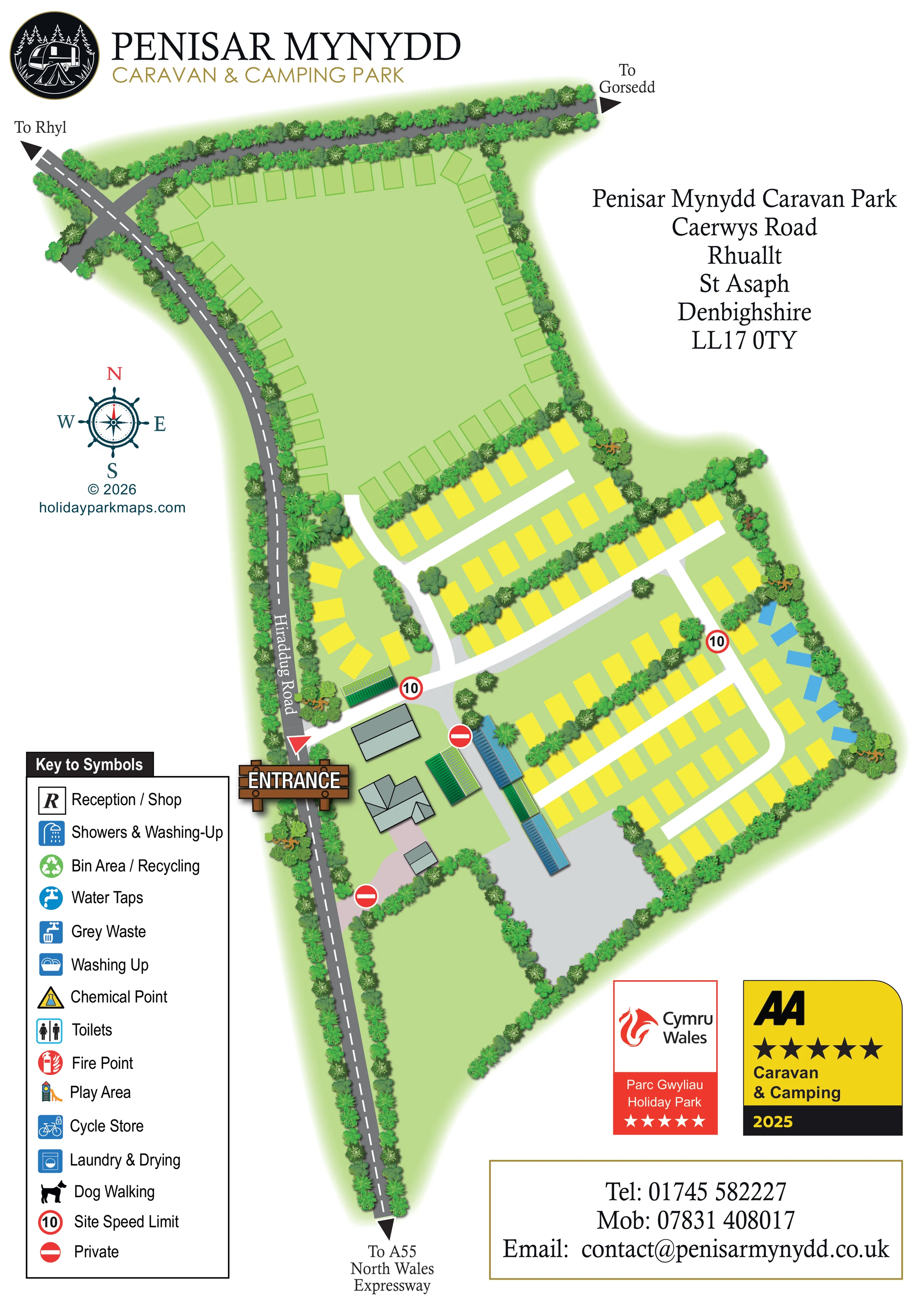
A broad green field has outlined rectangular pitches around much of its perimeter and an open centre.
An additional green enclosure and a broad grey area occupy the lower part of the plan; neither has a use label.
A prominent wooden-style ENTRANCE sign marks the arrival point from Hiraddug Road beside the building cluster.
The grey, dashed-centreline road follows the western boundary, with arrows towards Rhyl, Gorsedd and the A55 North Wales Expressway.
White branching lanes serve parallel pitch rows, with a curved return route through the lower-right accommodation area.
Two red-ringed 10 symbols appear on internal routes; the key identifies them as site speed-limit symbols.
Red no-entry-style symbols mark two branches near the entrance buildings. The key labels this symbol Private.
A prominent wooden-style ENTRANCE sign marks the arrival point from Hiraddug Road beside the building cluster.
The grey, dashed-centreline road follows the western boundary, with arrows towards Rhyl, Gorsedd and the A55 North Wales Expressway.
White branching lanes serve parallel pitch rows, with a curved return route through the lower-right accommodation area.
Two red-ringed 10 symbols appear on internal routes; the key identifies them as site speed-limit symbols.
Red no-entry-style symbols mark two branches near the entrance buildings. The key labels this symbol Private.
Dense illustrated planting encloses the park, borders the public road and separates several accommodation rows.
A broad green field has outlined rectangular pitches around much of its perimeter and an open centre.
An additional green enclosure and a broad grey area occupy the lower part of the plan; neither has a use label.
Several grey-roofed buildings and long blue or green structures are illustrated near the entrance. Their individual functions are not labelled.
Listed in the key with an italic R symbol, but no corresponding location marker is visible on the plan.
The key contains Showers & Washing-Up, Toilets and a separate Washing Up entry. Their positions are not marked in the visible plan.
Water taps, grey waste, a chemical point and a bin area / recycling symbol are included in the key without visible location markers.
A red fire-point icon appears in the key only.
A coloured climbing-frame and slide icon is listed in the key, without an identifiable placement on the plan.
A bicycle-and-lock symbol appears in the key only.
Listed with a blue washing-machine symbol; no location marker is visible.
A black dog silhouette is included in the key, but no dog-walking route or area is marked.
READING THE MAP
This illustrated map presents Penisar Mynydd Caravan & Camping Park at Rhuallt, near St Asaph in Denbighshire. Its portrait composition brings together a tree-lined site plan, a prominent entrance marker and clear connections towards Rhyl, Gorsedd and the A55 North Wales Expressway. The rural character comes through in the broad green spaces and densely planted boundaries, rather than through a detailed depiction of the surrounding countryside.
Two contrasting layouts give the map its structure: a large upper field with pitches around its perimeter, and a lower section arranged in yellow pitch rows along branching white access roads. Buildings cluster close to the entrance, while planted strips help separate the accommodation areas visually.
A substantial symbol key, compass rose, address block and contact panel make this a recognisable visitor-information sheet as well as a site illustration. For a sample gallery, it demonstrates a practical approach to a touring and camping park with several distinct pitch areas: simple accommodation shapes, strong road contrast and detailed planting provide an overview without relying on individual plot numbers.
The single portrait artwork places the park beside Hiraddug Road, which curves down its western edge. A dashed centreline distinguishes this public road from the broad white internal lanes. Direction arrows point towards Rhyl at the upper left, Gorsedd at the top and the A55 North Wales Expressway at the bottom. Near the main arrival point, a large illustrated timber sign reads ENTRANCE, with several grey-roofed buildings immediately inside the site.
The accommodation layout has two clear parts. The upper field is mostly open green space, surrounded on three sides and part of the fourth by green-outlined rectangular pitches. Below it, bright yellow rectangles follow several parallel access lanes, with additional pitches beside the entrance and along the right-hand boundary. A curved lane links the lower rows. Detailed tree and shrub bands frame the whole site and divide many of these groups. A further green enclosure and a broad grey area appear at the bottom without use labels.
Two red-ringed 10 markers and two private-access symbols are positioned on the plan. The tall key also lists reception / shop, showers and washing-up, toilets, water taps, recycling, grey waste, a chemical point, fire points, a play area, cycle storage, laundry and drying, and dog walking. These facility entries are not visibly located by matching symbols within the site drawing.
The page is completed by a compass rose, large address text, a gold-bordered contact panel and Cymru Wales and AA rating graphics. The accompanying enlargement repeats the entrance and key from this same artwork; it is not a separate park section or alternative map.
KEEP EXPLORING
Chosen for shared landscapes, accommodation or facilities.
 Explore the map ↗
United Kingdom
Woodland-framed Barnsoul map with mixed accommodation, shared facilities and paw-marked walking routes.
 Explore the map ↗
United Kingdom
Illustrated touring and camping map with hedge-divided fields, age-labelled play areas and a detailed service key.
 Explore the map ↗
United Kingdom
Woodland park map with mixed pitches, bell tents, lodges and a fishing lake.
Features may come from the sample artwork, its key or published park information. Approximate numbers describe the drawing and may cover only part of a park. They are intended to help you compare map examples. Current facilities and booking information should be checked with the park.
TAKE A CLOSER LOOK
View the illustrated map in detail or choose a file to download. These are sample maps; contact the park for current visitor information.

LET’S MAP YOUR PARK
For a map quotation, find your park and draw a rough boundary around it. The area you select helps us work out the design time and price.
Draw your park for a quote ↗Or talk to our map designers
01751 473136