
Tree and shrub boundary
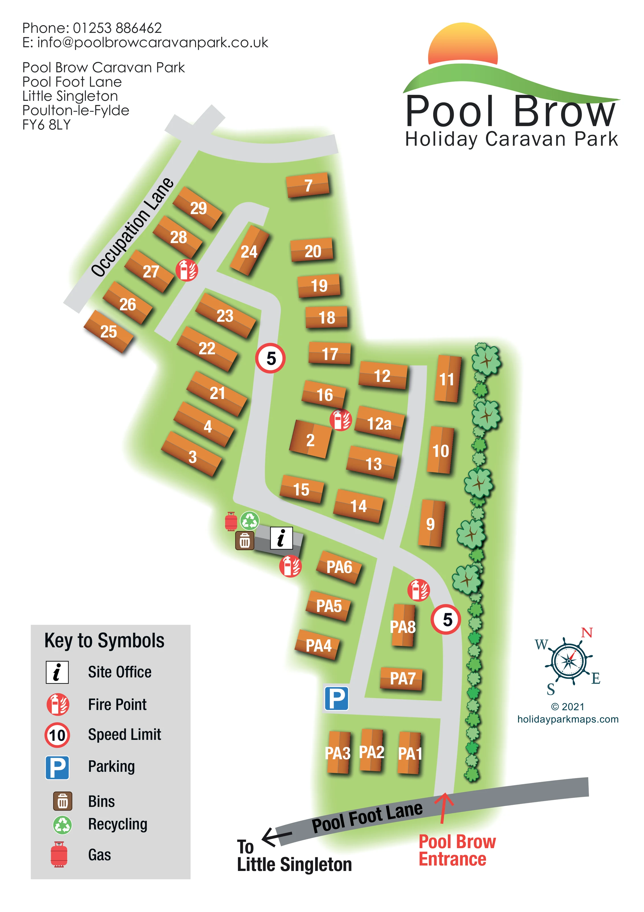
A conspicuous line of illustrated trees and smaller shrubs follows the right-hand boundary, beside green ground surrounding the units.
ILLUSTRATED PARK MAP · P573
Pool Foot Lane, Little Singleton, Poulton-le-Fylde · United Kingdom
 Enlarge the map ↗
A SENSE OF THE PLACE
Pool Brow Caravan Park is based at Pool Foot Lane, Little Singleton, Poulton-le-Fylde. This is a gated holiday-home park near Poulton-le-Fylde and the Fylde coast. Static caravans and holiday lodges are marketed for ownership.
The operator describes bus services stopping outside the park.
LOOK CLOSER
A conspicuous line of illustrated trees and smaller shrubs follows the right-hand boundary, beside green ground surrounding the units.
An information symbol marks a grey building beside the central road junction, close to the bins, recycling and gas symbols.
A blue parking symbol appears beside the lower internal cross-road, within the entrance-side accommodation group.
Repeated red extinguisher symbols mark fire points around the northern accommodation rows, central units, office and lower road.
Brown bin and green recycling symbols are grouped immediately beside the site office.
A red gas-cylinder symbol is shown next to the office-side service cluster.
Two red-ringed markers displaying 5 appear on the internal roads. The key identifies the symbol category as Speed Limit.
A large red arrow and label identify the entrance from Pool Foot Lane at the bottom of the plan.
An information symbol marks a grey building beside the central road junction, close to the bins, recycling and gas symbols.
A blue parking symbol appears beside the lower internal cross-road, within the entrance-side accommodation group.
Repeated red extinguisher symbols mark fire points around the northern accommodation rows, central units, office and lower road.
Brown bin and green recycling symbols are grouped immediately beside the site office.
A red gas-cylinder symbol is shown next to the office-side service cluster.
Two red-ringed markers displaying 5 appear on the internal roads. The key identifies the symbol category as Speed Limit.
A large red arrow and label identify the entrance from Pool Foot Lane at the bottom of the plan.
Pool Foot Lane crosses the lower edge of the page; Occupation Lane runs diagonally along the upper-left edge. An outward arrow on Pool Foot Lane points towards Little Singleton.
Broad pale-grey roads connect the entrance-side circuit with central accommodation rows and a short turning-ended branch towards the upper-left part of the park.
A conspicuous line of illustrated trees and smaller shrubs follows the right-hand boundary, beside green ground surrounding the units.
The operator describes the park as gated; the artwork labels the entrance without separately illustrating or labelling a gate.
The operator describes bus services stopping outside the park. No bus-stop position is marked on this plan.
READING THE MAP
This portrait map of Pool Brow Caravan Park presents a small holiday-home site at Little Singleton, near Poulton-le-Fylde and the Fylde coast. Its main task is straightforward: help visitors connect the entrance on Pool Foot Lane with an individually labelled caravan, the site office and the park’s everyday service points.
The plan shows roughly 35 accommodation units as orange, shaded roof blocks on a light-green ground. Broad grey roads link the entrance-side group with the larger arrangement of units towards Occupation Lane. A planted boundary of trees and shrubs gives the right side of the site a distinctive visual edge, while generous white space keeps the surrounding labels clear.
Pool Brow’s sun-and-hill logo occupies the upper-right corner, balanced by address and contact details on the left. Below, a prominent symbol key explains parking, fire points, bins, recycling, gas and the office. The red entrance arrow, direction towards Little Singleton and decorative compass complete a practical example of branded wayfinding for a compact caravan park.
The artwork is a single portrait site plan, with Pool Foot Lane crossing its lower edge and Occupation Lane running diagonally beside the upper-left accommodation rows. A red arrow labelled Pool Brow Entrance marks the connection between the external lane and the park road. A separate black arrow points along Pool Foot Lane towards Little Singleton.
Inside the park, pale-grey roads organise the accommodation into several short rows and groups. The lower section contains PA-prefixed units around a compact road circuit, with a blue parking symbol beside its cross-road. Farther up, the road network opens into central rows, an inner branch and a short turning-ended spur towards the upper left. The map uses large white labels directly on the orange units, so accommodation references can be read without consulting a separate index. The roof blocks have two-tone shading and dark shadows, adding depth while preserving the clarity of an overhead plan.
The site office is drawn as a grey building near the central junction. Bins, recycling and gas symbols are clustered beside it, and red fire-point symbols recur through the accommodation areas. Red-ringed speed markers are positioned on the internal roads. Along the right-hand boundary, illustrated trees and smaller shrubs form a continuous green edge; elsewhere, the ground fades softly into the white page.
The lower-left key presents seven symbol categories in a generous grey panel. A nautical-style compass and designer credit occupy the open space to the right. Above the plan, the large sun-and-hill logo and contact block establish the park’s identity. The detail enlargements show portions of this same artwork, not additional park sections or alternative layouts.
KEEP EXPLORING
Chosen for shared landscapes, accommodation or facilities.
 Explore the map ↗
United Kingdom
Illustrated coastal holiday-home plan with dense alphanumeric plot labels, orange-roofed amenities, a numbered facility key and beach-side context.
 Explore the map ↗
United Kingdom
A colour-zoned coastal park map with touring areas, woodland trails, ponds and a leisure club.
 Explore the map ↗
United Kingdom
Colour-coded accommodation, central leisure facilities and coastal paths on an illustrated headland park map.
Features may come from the sample artwork, its key or published park information. Approximate numbers describe the drawing and may cover only part of a park. They are intended to help you compare map examples. Current facilities and booking information should be checked with the park.
TAKE A CLOSER LOOK
View the illustrated map in detail or choose a file to download. These are sample maps; contact the park for current visitor information.


LET’S MAP YOUR PARK
For a map quotation, find your park and draw a rough boundary around it. The area you select helps us work out the design time and price.
Draw your park for a quote ↗Or talk to our map designers
01751 473136