
Dam
An irregular bright-blue water shape labelled DAM lies between the left-hand pitch cluster and reception.
ILLUSTRATED PARK MAP · P264
Yeodene, Victoria, Australia · Australia
 Enlarge the map ↗
A SENSE OF THE PLACE
Possum Ridge Retreat by Tiny Away is based at Yeodene, Victoria, Australia. The site offers tiny-house accommodation in rural Yeodene amid bushland, birdlife and a dam.
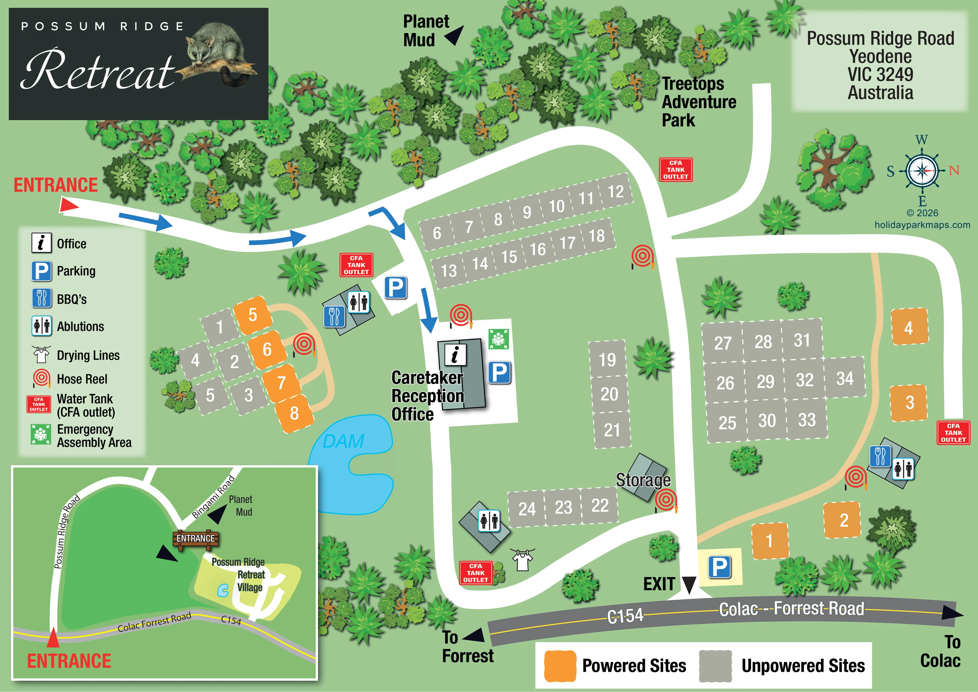
The map brings the site layout and its access routes together in one view, providing a reference for understanding the arrangement of the grounds.
LOOK CLOSER
An irregular bright-blue water shape labelled DAM lies between the left-hand pitch cluster and reception.
Dense illustrated tree canopies frame the upper approach, with smaller groups around the lower edge and scattered trees between pitches.
A central building beside the arrival route is labelled Caretaker Reception Office and carries the information symbol.
Blue parking symbols mark provision near reception, beside the upper-left amenity building and close to the exit.
Three small roof-plan buildings carry male and female ablution symbols, distributed beside the left, lower-central and right-hand pitch groups.
Barbecue symbols share the left and right amenity-building locations with ablution symbols.
A clothesline symbol is positioned beside the lower-central ablution building.
Red coiled-hose symbols recur around accommodation areas, reception and the storage building.
A central building beside the arrival route is labelled Caretaker Reception Office and carries the information symbol.
Blue parking symbols mark provision near reception, beside the upper-left amenity building and close to the exit.
Three small roof-plan buildings carry male and female ablution symbols, distributed beside the left, lower-central and right-hand pitch groups.
Barbecue symbols share the left and right amenity-building locations with ablution symbols.
A clothesline symbol is positioned beside the lower-central ablution building.
Red coiled-hose symbols recur around accommodation areas, reception and the storage building.
Red CFA Tank Outlet markers are placed at several points around the road network and amenity areas; the legend describes them as water tanks with CFA outlets.
A green assembly-point symbol is shown immediately beside the reception building.
A small roof-plan building labelled Storage stands beside the lower-central road junction.
An irregular bright-blue water shape labelled DAM lies between the left-hand pitch cluster and reception.
Dense illustrated tree canopies frame the upper approach, with smaller groups around the lower edge and scattered trees between pitches.
The main plan marks an entrance at the left and an exit onto Colac–Forrest Road at the lower edge. Blue arrows trace the arrival route towards reception.
Broad white roads form a central spine and curved circuits around the pitch groups. Narrow tan routes serve the powered-site areas.
A framed inset relates the retreat to Possum Ridge Road, Bingami Road and Colac–Forrest Road, with entrance markers and a simplified outline of the grounds.
The external road is drawn across the bottom of the main plan, with directional arrows towards Forrest and Colac.
Treetops Adventure Park is named beside an upper road branch, providing an adjoining destination reference rather than a detailed attraction layout.
Planet Mud appears with a directional arrow above the main plan and is also referenced beside Bingami Road in the inset.
READING THE MAP
This map of Possum Ridge Retreat in Yeodene, Victoria, combines a compact site plan with a local-road inset. A wooded approach, a bright-blue dam and scattered tree canopies establish the rural setting, while broad white roads make the arrangement of the grounds easy to follow. The artwork distinguishes powered sites in orange from unpowered sites in grey, using large numbers and dashed boundaries rather than illustrations of individual accommodation units.
Arrival is a particular focus. A red entrance marker and blue direction arrows lead towards the central caretaker, reception and office building, while a separate exit connects with Colac–Forrest Road. The inset adds the wider relationship between that road, Possum Ridge Road and Bingami Road, helping visitors understand both the approach and the internal layout.
The design also brings together everyday facilities and operational landmarks: parking, ablutions, barbecues, drying lines, storage, hose reels, CFA tank outlets and an emergency assembly area. A large possum-branded title panel gives the page a distinctive identity without replacing the practical information needed to navigate the site.
The main plan is built around a white central road running past reception towards the exit on Colac–Forrest Road. From the left-hand entrance, a curving approach passes through illustrated woodland before blue arrows direct arrivals down to the office. Branching roads wrap around the accommodation areas, with an upper branch beside the Treetops Adventure Park label.
The map shows roughly 40 pitches in two clearly keyed categories. Grey unpowered sites occupy paired rows near the top, short strips in the centre, a block on the right and a smaller cluster on the left. Orange powered sites form a compact group beside the dam and a more loosely spaced line on the right. Narrow tan routes connect these powered-site areas. White pitch numbers and dashed boundaries remain visually separate from the roads and landscape symbols.
Reception sits close to the dam, with parking and a green emergency assembly marker alongside it. Three amenity buildings distribute ablution symbols across the grounds; the left and right buildings also carry barbecue symbols. Drying lines appear beside the lower-central amenity building, and a separate storage building marks another useful landmark. Red hose reels and CFA tank-outlet markers are repeated around the site.
The lower-left inset is an approach map, not a second accommodation area. It shows Possum Ridge Road, Bingami Road and the C154, together with entrance markers, the retreat village outline and a Planet Mud direction. The main plan adds arrows towards Forrest and Colac. A facility legend, separate pitch-colour key, address panel and right-facing north compass complete the single-page composition.
KEEP EXPLORING
Chosen for shared landscapes, accommodation or facilities.
 Explore the map ↗
United Kingdom
Ashby Park map with seven fishing lakes, colour-coded accommodation and illustrated wooded shorelines.
 Explore the map ↗
United Kingdom
Woodland-framed Barnsoul map with mixed accommodation, shared facilities and paw-marked walking routes.
 Explore the map ↗
United Kingdom
A wooded, streamside park map with a linked farm, café, touring and cottage area.
Features may come from the sample artwork, its key or published park information. Approximate numbers describe the drawing and may cover only part of a park. They are intended to help you compare map examples. Current facilities and booking information should be checked with the park.
LET’S MAP YOUR PARK
For a map quotation, find your park and draw a rough boundary around it. The area you select helps us work out the design time and price.
Draw your park for a quote ↗Or talk to our map designers
01751 473136