
Open lawns and planted boundaries
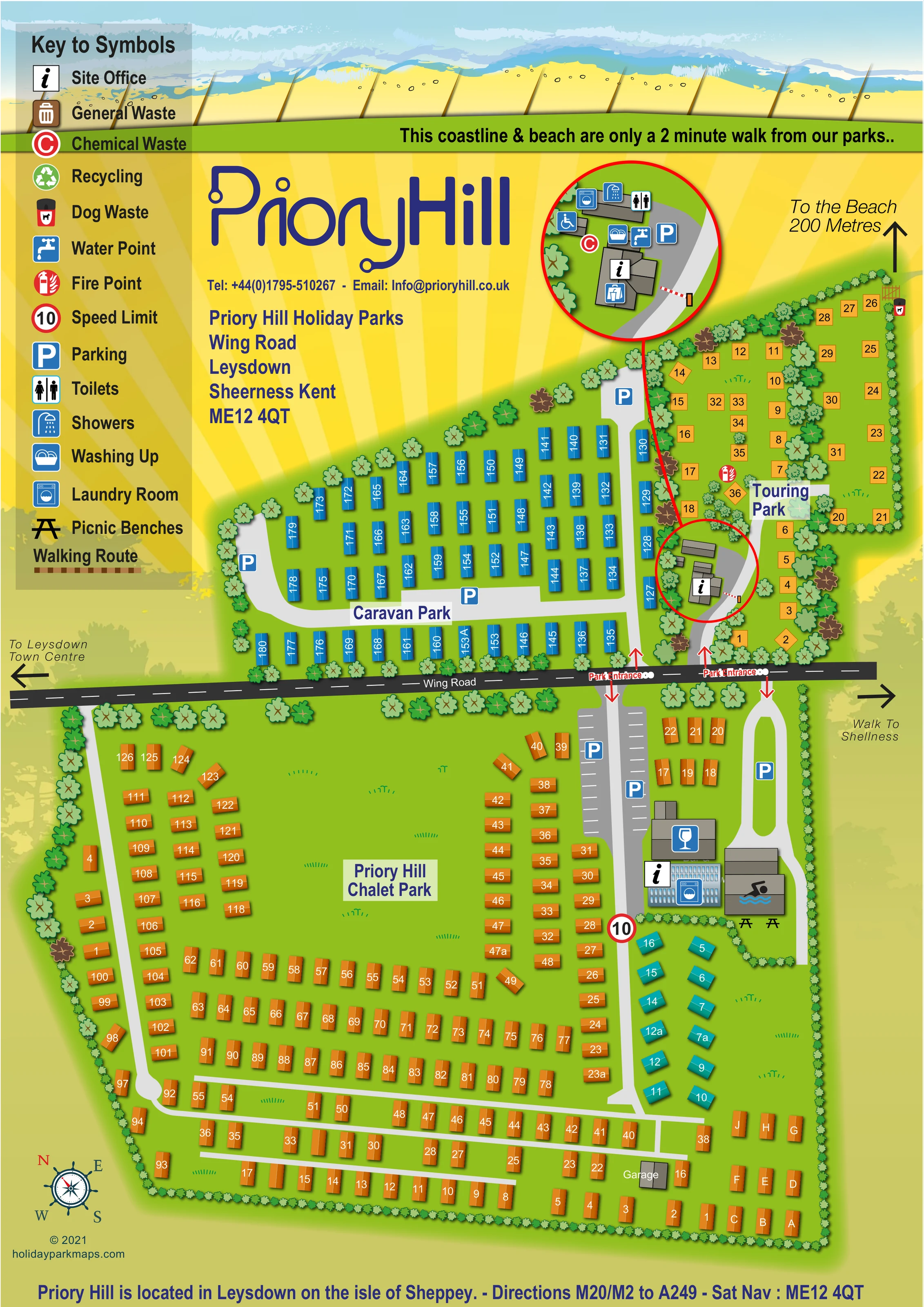
A broad open lawn anchors the chalet area, with continuous illustrated trees and shrubs enclosing most sections and separating some pitch groups.
ILLUSTRATED PARK MAP · P577
Priory Hill Holiday Parks, Wing Road, Leysdown, Sheerness Kent · United Kingdom
 Enlarge the map ↗
A SENSE OF THE PLACE
Priory Hill is a family-run holiday park at Leysdown on the Isle of Sheppey. Caravan, lodge and chalet ownership forms a central part of its coastal offering.
The park operates alongside neighbouring Nutts Farm, where touring is also provided. Beaches and traditional seaside attractions are close by, while the map focuses on Priory Hill's own accommodation layout and internal routes.
LOOK CLOSER
A broad open lawn anchors the chalet area, with continuous illustrated trees and shrubs enclosing most sections and separating some pitch groups.
Sea, surf, sand and groynes form a decorative coastal header rather than a surveyed shoreline within the park plan.
Information symbols identify an office in the southern facilities cluster and another at the touring entrance, also shown in the circular enlargement.
A swimmer-and-wave pictogram identifies a grey building in the southern facilities cluster.
A drinks-glass symbol marks the building beside the office, laundry and pool; the extracted artwork text names 'Bar & Club'.
Laundry symbols appear in the southern facilities cluster and in the enlarged touring service area.
The circular touring-area enlargement locates toilets, showers and washing-up facilities around the service buildings.
A wheelchair symbol appears beside a building in the touring service-area enlargement. It identifies an accessibility-related facility without specifying its provision.
Information symbols identify an office in the southern facilities cluster and another at the touring entrance, also shown in the circular enlargement.
A swimmer-and-wave pictogram identifies a grey building in the southern facilities cluster.
A drinks-glass symbol marks the building beside the office, laundry and pool; the extracted artwork text names 'Bar & Club'.
Laundry symbols appear in the southern facilities cluster and in the enlarged touring service area.
The circular touring-area enlargement locates toilets, showers and washing-up facilities around the service buildings.
A wheelchair symbol appears beside a building in the touring service-area enlargement. It identifies an accessibility-related facility without specifying its provision.
Water and chemical-waste symbols are positioned in the enlarged touring service area.
A red fire-point symbol is shown within the Touring Park.
A dog-waste bin symbol appears at the north-eastern edge near the beach direction.
Both services are explained in the key, but their positions are not clearly established on the main plan.
Blue parking symbols mark several areas across the plan, including marked bays south of Wing Road and parking within the caravan and touring sections.
Two bench pictograms sit immediately below the swimming-pool building.
A small grey building in the southern chalet rows is labelled 'Garage'.
Wing Road crosses the middle of the artwork. Two labelled entrance positions connect the accommodation areas on either side.
A red-and-white barrier is illustrated at the touring entrance and repeated in the service-area enlargement.
A circular '10' sign is placed on the southern internal route and explained in the key.
An arrow at the upper right reads 'To the Beach 200 Metres'. A separate banner promotes the nearby coastline.
Opposing arrows along Wing Road indicate Leysdown town centre to the left and a walk towards Shellness to the right.
A brown segmented line is defined as a walking route in the key; no complete corresponding route is clearly traceable across the plan.
A broad open lawn anchors the chalet area, with continuous illustrated trees and shrubs enclosing most sections and separating some pitch groups.
Sea, surf, sand and groynes form a decorative coastal header rather than a surveyed shoreline within the park plan.
READING THE MAP
This illustrated map presents Priory Hill Holiday Park at Leysdown on Kent’s Isle of Sheppey, using a bright seaside palette and clearly separated accommodation areas. Wing Road runs across the page, dividing the caravan and touring sections from the larger chalet park below. Blue caravan units, yellow-orange touring pitches and predominantly orange chalets give each part of the layout a recognisable visual identity.
The map combines individual accommodation labels with practical visitor information. Parking, offices, laundry facilities, the bar and club, and the swimming pool are shown alongside internal roads and planted boundaries. A circular enlargement gives extra space to the touring entrance and its closely grouped service symbols, without overcrowding the main plan.
Coastal character is carried through the sea-and-sand header, yellow sunburst and beach-direction arrow. Directions towards Leysdown town centre and Shellness place the park within its immediate surroundings. This sample demonstrates a branded visitor map for a mixed accommodation site whose separate sections share a road frontage and need a coherent overall presentation.
The portrait artwork organises the park around Wing Road, shown as a black horizontal road with dashed white markings. Above it, the Caravan Park occupies a compact western block of blue units, while the Touring Park follows a narrower strip along the eastern boundary. Below the road, the Priory Hill Chalet Park fills most of the page. Its orange units frame a large open lawn before continuing into closer rows towards the southern edge. A smaller turquoise group sits near the main facilities.
Pale grey roads lead through the accommodation areas, with parking symbols and marked bays identifying places to leave vehicles. Two entrance positions are highlighted beside Wing Road. The southern facilities cluster brings together the office, laundry, bar and club, and swimming-pool building; picnic-bench symbols appear beneath the pool. A garage is labelled among the lower chalet rows.
The touring entrance is shown both on the main plan and in a red-ringed circular enlargement above it. This inset separates the office, laundry, toilets, showers, washing-up, water and chemical-waste symbols so that the service area is easier to read. It also shows a wheelchair symbol and an entrance barrier. A fire point and dog-waste point are marked elsewhere in the touring section.
Trees and shrubs trace the park boundaries and soften the accommodation blocks. Large arrows indicate the beach, Leysdown town centre and the walk towards Shellness. The upper-left key, compass rose, prominent Priory Hill branding and coastal header complete the composition. The accompanying detail view enlarges the existing legend and part of the plan; it is not a separate map or additional accommodation area.
KEEP EXPLORING
Chosen for shared landscapes, accommodation or facilities.
 Explore the map ↗
United Kingdom
A colour-zoned coastal park map with touring areas, woodland trails, ponds and a leisure club.
 Explore the map ↗
United Kingdom
Colour-coded accommodation, central leisure facilities and coastal paths on an illustrated headland park map.
 Explore the map ↗
United Kingdom
Illustrated Suffolk coastal park map with planted accommodation rows, central pitches, leisure facilities and beach directions.
Features may come from the sample artwork, its key or published park information. Approximate numbers describe the drawing and may cover only part of a park. They are intended to help you compare map examples. Current facilities and booking information should be checked with the park.
TAKE A CLOSER LOOK
View the illustrated map in detail or choose a file to download. These are sample maps; contact the park for current visitor information.


LET’S MAP YOUR PARK
For a map quotation, find your park and draw a rough boundary around it. The area you select helps us work out the design time and price.
Draw your park for a quote ↗Or talk to our map designers
01751 473136
 chaletpark.png
 touringpark.png
 chaletpark_large.png
 touringpark_large.png