
Farm buildings and yard
Green-roofed agricultural buildings and a grey farmyard occupy the upper-left corner, separately marked from the visitor accommodation.
ILLUSTRATED PARK MAP · P266
Pyscodlyn Caravan & Campsite, Llanwenarth Citra, Abergavenny, Monmouthshire · United Kingdom
 Enlarge the map ↗
A SENSE OF THE PLACE
Pyscodlyn Farm Caravan and Camping Park lies in the Usk Valley near Abergavenny. Level grass camping and touring areas provide a base for exploring Crickhowell and the Black Mountains.
Electric connections, toilets, showers and laundry are available, with a static caravan also offered for hire. Dogs are welcomed and have a dedicated exercise area. The map shows the arrangement of the main touring and separate camping spaces.
LOOK CLOSER
Green-roofed agricultural buildings and a grey farmyard occupy the upper-left corner, separately marked from the visitor accommodation.
Two grass areas between the entrance and accommodation are explicitly labelled Private Field.
Dense illustrated trees and shrubs enclose the camping field, screen the private fields and line much of the park perimeter. Smaller planted strips divide central pitch rows.
An information-style reception symbol marks the orange-roofed building beside the entrance drive, south of the farmyard.
Two service clusters are shown: female toilets and showers beside the western camping field, and male toilets and showers beside the northern static-caravan row.
A wheelchair pictogram appears beside the northern toilet and shower symbols. It marks a facility provision but does not establish detailed accessibility specifications.
A blue shirt symbol locates laundry beside the western toilet and shower cluster.
An Elsan symbol is placed beside the northern service building, close to the static caravans.
An information-style reception symbol marks the orange-roofed building beside the entrance drive, south of the farmyard.
Two service clusters are shown: female toilets and showers beside the western camping field, and male toilets and showers beside the northern static-caravan row.
A wheelchair pictogram appears beside the northern toilet and shower symbols. It marks a facility provision but does not establish detailed accessibility specifications.
A blue shirt symbol locates laundry beside the western toilet and shower cluster.
An Elsan symbol is placed beside the northern service building, close to the static caravans.
Blue tap symbols mark water points at both service clusters.
A brown waste-bin symbol appears beside the northern service cluster.
Red fire-point symbols are distributed beside the camping field, non-electric area and southern grass space.
Yellow lightning symbols identify electric provision among the numbered grass pitches, western camping-side spaces and grey hardstandings.
Grey rectangular pitches are shown near the northern internal junction and along the southern edge.
Green-roofed agricultural buildings and a grey farmyard occupy the upper-left corner, separately marked from the visitor accommodation.
Two grass areas between the entrance and accommodation are explicitly labelled Private Field.
Dense illustrated trees and shrubs enclose the camping field, screen the private fields and line much of the park perimeter. Smaller planted strips divide central pitch rows.
The entrance is connected to the A40, with directional labels for Crickhowell, 4 miles, and Abergavenny, 2.5 miles.
A white entrance drive passes reception and the private fields before joining a broad loop around the principal pitch area.
Footprints and a small illustrated gate identify a pedestrian exit at the south-eastern boundary.
A grey lane outside the eastern boundary is labelled as leading to Abergavenny and the River Usk. The river itself is not illustrated.
No-entry symbols distinguish the farmyard and southern private driveway from visitor routes.
Red-bordered signs displaying 5 are placed at several points on the internal road and explained by the legend as Site Speed.
READING THE MAP
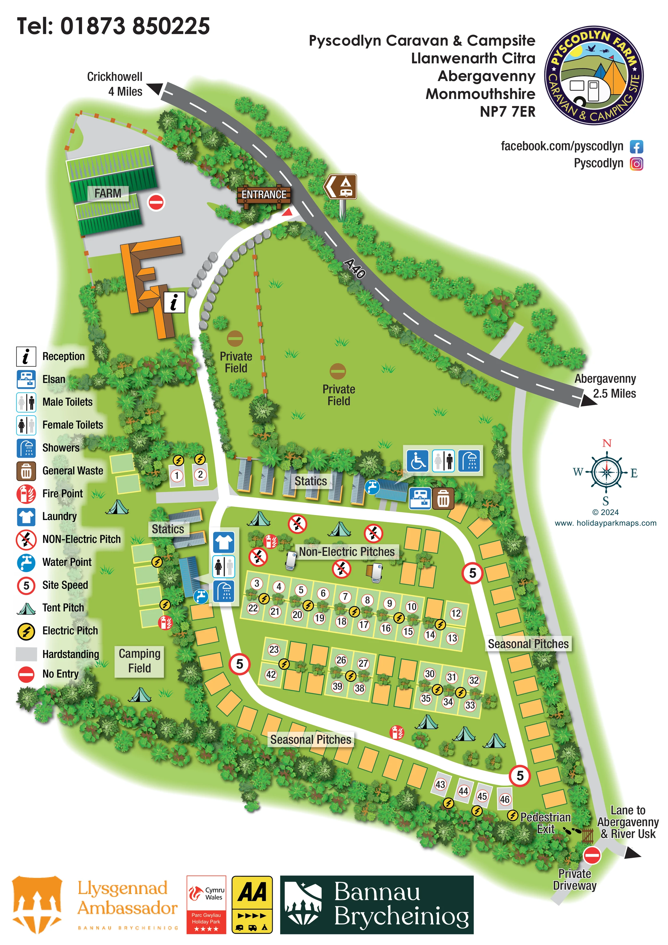
This illustrated map of Pyscodlyn Farm Caravan & Camping Park presents a leafy touring and camping site near Abergavenny in Monmouthshire. The farm buildings, reception and signed entrance establish the arrival point beside the A40, while a clear white drive leads visitors into the accommodation areas below. Two private fields remain visible within the plan, helping explain the relationship between the farm setting and the guest spaces.
The map distinguishes a separate camping field, non-electric grass pitches, small groups of static caravans and a main touring area arranged around a loop road. Orange seasonal pitches follow much of the perimeter, contrasting with pale outlined touring spaces and grey hardstandings. A substantial symbol key helps visitors locate toilets, showers, laundry, water and other practical facilities without overloading the drawing with text.
Trees, hedges, roof details and small tent illustrations give the plan its rural character. Town directions, a compass and a pedestrian exit towards the lane to Abergavenny and the River Usk extend its usefulness beyond finding a pitch.
The portrait composition follows the park from its northern arrival area to the pedestrian gate at the southern end. Across the top, the dark grey A40 carries directions towards Crickhowell and Abergavenny. A wooden entrance sign marks the turning into a curving white driveway, edged with illustrated boulders near reception. Green-roofed farm sheds and their yard sit to the left, while two labelled private fields occupy the grass to the right.
Below these fields, a row of static caravans forms the northern edge of the main accommodation area. A smaller static group sits beside the western Camping Field. The drive continues between these groups and opens into a loop around the central pitches. Paired rows of numbered grass spaces use pale yellow outlines, with yellow lightning symbols indicating electric provision. Grey hardstandings are visually distinct, and orange seasonal spaces line much of the eastern and southern circuit. The non-electric area is labelled separately and includes tent and caravan illustrations.
Service symbols are concentrated in two useful clusters. Beside the camping field, the map shows laundry, female toilets, showers and water. Near the northern static row, it shows male toilets, showers, a wheelchair symbol, water, Elsan disposal and general waste. Fire points are distributed around the accommodation areas, and repeated red-bordered speed signs punctuate the road.
Dense illustrated planting encloses the site and divides selected pitch rows. At the south-eastern corner, footprints and a gate mark the pedestrian exit onto the external lane, labelled towards Abergavenny and the River Usk. The left-hand legend, right-side compass and branded footer complete the single-page design.
KEEP EXPLORING
Chosen for shared landscapes, accommodation or facilities.
 Explore the map ↗
United Kingdom
Riverside park map with named pitch fields, illustrated huts and a paw-print dog walk.
 Explore the map ↗
United Kingdom
Woodland holiday homes, named camping fields and farm buildings on a colour-coded Nether Wasdale park map.
 Explore the map ↗
United Kingdom
Illustrated caravan park plan with woodland and riverside walks, fishing pools and wildlife panels.
Features may come from the sample artwork, its key or published park information. Approximate numbers describe the drawing and may cover only part of a park. They are intended to help you compare map examples. Current facilities and booking information should be checked with the park.
LET’S MAP YOUR PARK
For a map quotation, find your park and draw a rough boundary around it. The area you select helps us work out the design time and price.
Draw your park for a quote ↗Or talk to our map designers
01751 473136