
River Maun
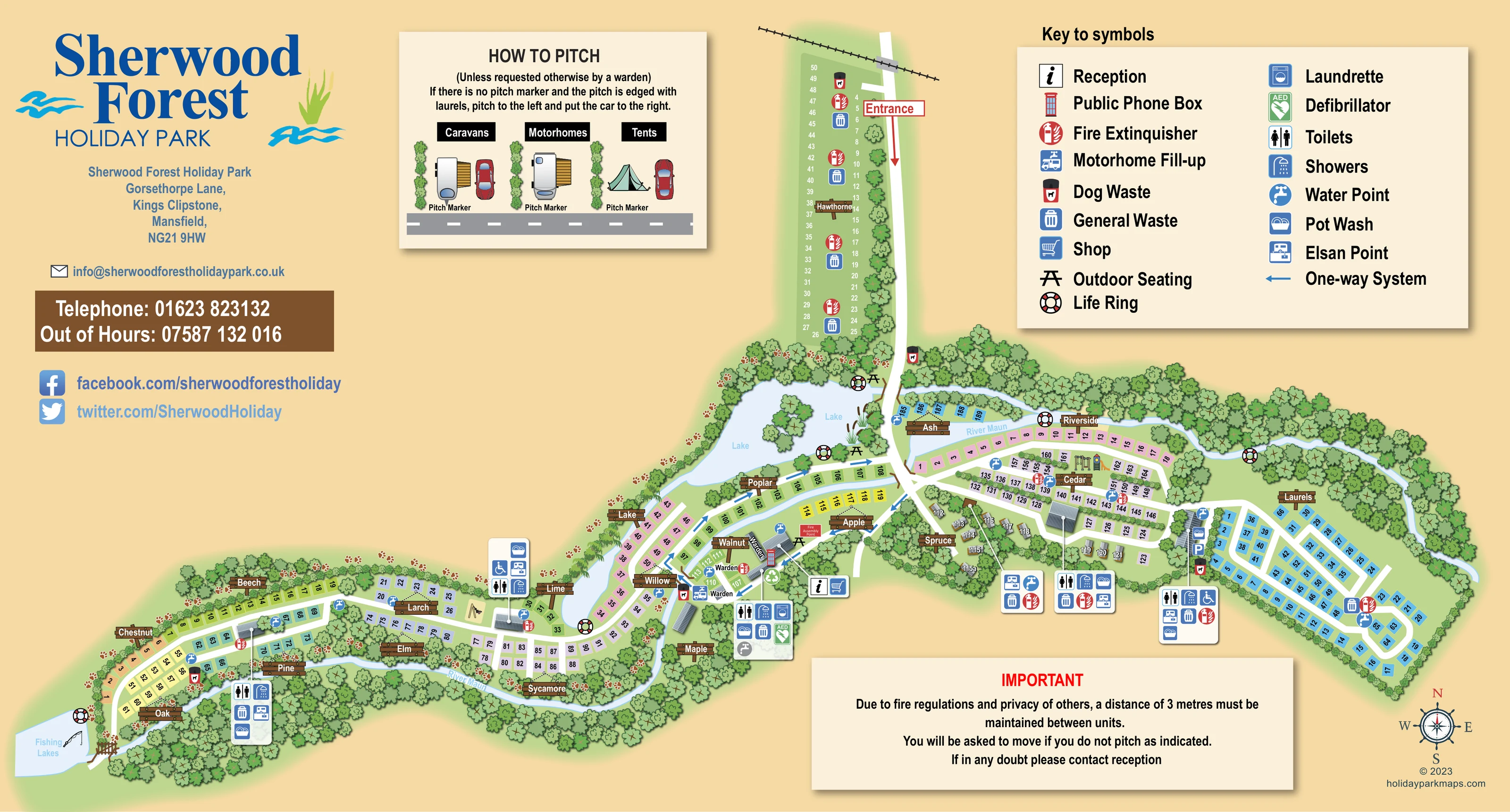
A winding pale-blue river links the western and eastern parts of the composition and borders several pitch areas.
ILLUSTRATED PARK MAP · P296
Sherwood Forest Holiday Park, Gorsethorpe Lane, Kings Clipstone, Mansfield · United Kingdom
 Enlarge the map ↗
A SENSE OF THE PLACE
Sherwood Forest Holiday Park is a touring and camping site beside the River Maun near Kings Clipstone. Woodlands, mature trees, fields and lakes give the grounds a strong natural character.
Tents, caravans and motorhomes are welcomed, with wildlife frequently part of the surroundings. The map helps guests navigate the camping areas and shared facilities within the landscaped Maun Valley setting.
LOOK CLOSER
A winding pale-blue river links the western and eastern parts of the composition and borders several pitch areas.
Two irregular lakes sit beside the entrance approach, surrounded by trees, reeds, seating and life-ring symbols.
A labelled water area with a fishing-rod illustration appears at the far western end.
Dense illustrated trees enclose the park, line the watercourses and divide accommodation areas; flowering shrubs and hedges add smaller-scale planting.
Information and shopping symbols identify a central service point near Maple and the main route junction.
Grouped facility panels identify several washroom and washing-up locations serving the western, central and eastern pitch areas.
A washing-machine symbol appears in the central facilities panel.
Wheelchair symbols accompany some facility groups; the map does not specify their detailed provision.
Information and shopping symbols identify a central service point near Maple and the main route junction.
Grouped facility panels identify several washroom and washing-up locations serving the western, central and eastern pitch areas.
A washing-machine symbol appears in the central facilities panel.
Wheelchair symbols accompany some facility groups; the map does not specify their detailed provision.
Blue tap symbols are distributed among the accommodation rows and service areas.
Motorhome servicing and chemical disposal symbols appear in several grouped service panels.
Waste symbols recur along the entrance strip, pitch areas and shared routes.
Red extinguisher symbols are distributed throughout the site.
A green AED symbol is included in the central facilities group near Maple.
A red labelled assembly point is shown beside Apple.
Life-ring symbols mark several locations beside the river and lakes.
Picnic-table symbols appear beside the central lakes.
A swing and slide are illustrated within the Cedar area.
Listed in the key; its position is not clearly identifiable in the supplied views.
Several Warden labels are placed around the central Walnut and Maple area.
A blue P marker is shown beside the facilities between Cedar and Laurels.
A winding pale-blue river links the western and eastern parts of the composition and borders several pitch areas.
Two irregular lakes sit beside the entrance approach, surrounded by trees, reeds, seating and life-ring symbols.
A labelled water area with a fishing-rod illustration appears at the far western end.
Dense illustrated trees enclose the park, line the watercourses and divide accommodation areas; flowering shrubs and hedges add smaller-scale planting.
The entrance is prominently marked at the top of the long Hawthorne strip, leading towards the central lakes and main route junction.
White roads connect the pitch rows and form local loops. Direction arrows appear on the entrance approach and selected internal sections.
Brown-edged crossings carry routes over water near the central junction and western fishing-lake area.
READING THE MAP
This illustrated map of Sherwood Forest Holiday Park presents a touring and camping site shaped by the River Maun, lakes and mature planting near Kings Clipstone, Mansfield. Rather than reducing the grounds to a simple grid, the design follows their long, branching form: a northern entrance approach leads into two broad accommodation wings, with water and woodland providing recognisable landmarks along the way.
Numbered pitches sit in pastel-coloured groups, each accompanied by a timber-style section sign. Names such as Willow, Cedar, Oak and Riverside reinforce the park’s wooded character while helping visitors identify their part of the site. White internal roads stand out clearly against the green grounds, and familiar symbols locate reception, the shop, washrooms, water points and touring services.
The landscape-format page also makes room for a large symbol key, park branding and a practical pitching diagram for caravans, motorhomes and tents. It is a useful example of combining detailed guest navigation with an illustrated account of a park’s natural setting, without allowing the surrounding information panels to obscure the plan.
The plan’s most distinctive structural feature is its long entrance spur. Hawthorne occupies a narrow strip beside the approach road at the top of the page. This route descends towards two lakes and a central junction, from which the main accommodation areas spread west and east. The River Maun winds through the composition, passing wooded margins, pitch rows and the area labelled Riverside.
To the west, roads connect sections including Chestnut, Oak, Pine, Beech, Elm, Larch and Sycamore. The fishing lakes appear at the far end, with a small illustrated crossing nearby. Closer to the centre, Lake, Willow, Poplar, Walnut and Apple sit around water and shared routes. Warden labels and the reception and shop symbols establish a central service cluster near Maple. Spruce contains individually illustrated roofed units among trees, contrasting with the flat numbered pitch rectangles used across most of the site.
The eastern wing includes Cedar, where small play equipment is drawn, and the larger Laurels area, organised around several parallel rows and connecting loops. Facility panels group toilets, showers, pot washing, disposal and other services beside their locations. Smaller standalone symbols distribute water, waste and fire points through the grounds, while life rings and picnic tables help describe the lakeside areas.
The page is a single integrated design, with a separate enlargement providing a closer view of the key and eastern-central detail rather than another map variant. Above the plan, the branding, pitching instructions and two-column legend occupy the open background. Below, a notice panel and compass complete the visitor-information layout. Timber signs, pastel pitches and dense tree illustration give the detailed plan a consistent visual language.
KEEP EXPLORING
Chosen for shared landscapes, accommodation or facilities.
 Explore the map ↗
United Kingdom
Woodland park map with mixed pitches, bell tents, lodges and a fishing lake.
 Explore the map ↗
United Kingdom
A lakeside holiday-park and fishery map with numbered accommodation, fishing positions and clearly grouped visitor services.
 Explore the map ↗
United Kingdom
Illustrated caravan park plan with woodland and riverside walks, fishing pools and wildlife panels.
Features may come from the sample artwork, its key or published park information. Approximate numbers describe the drawing and may cover only part of a park. They are intended to help you compare map examples. Current facilities and booking information should be checked with the park.
LET’S MAP YOUR PARK
For a map quotation, find your park and draw a rough boundary around it. The area you select helps us work out the design time and price.
Draw your park for a quote ↗Or talk to our map designers
01751 473136