
Woodland and grassy clearings
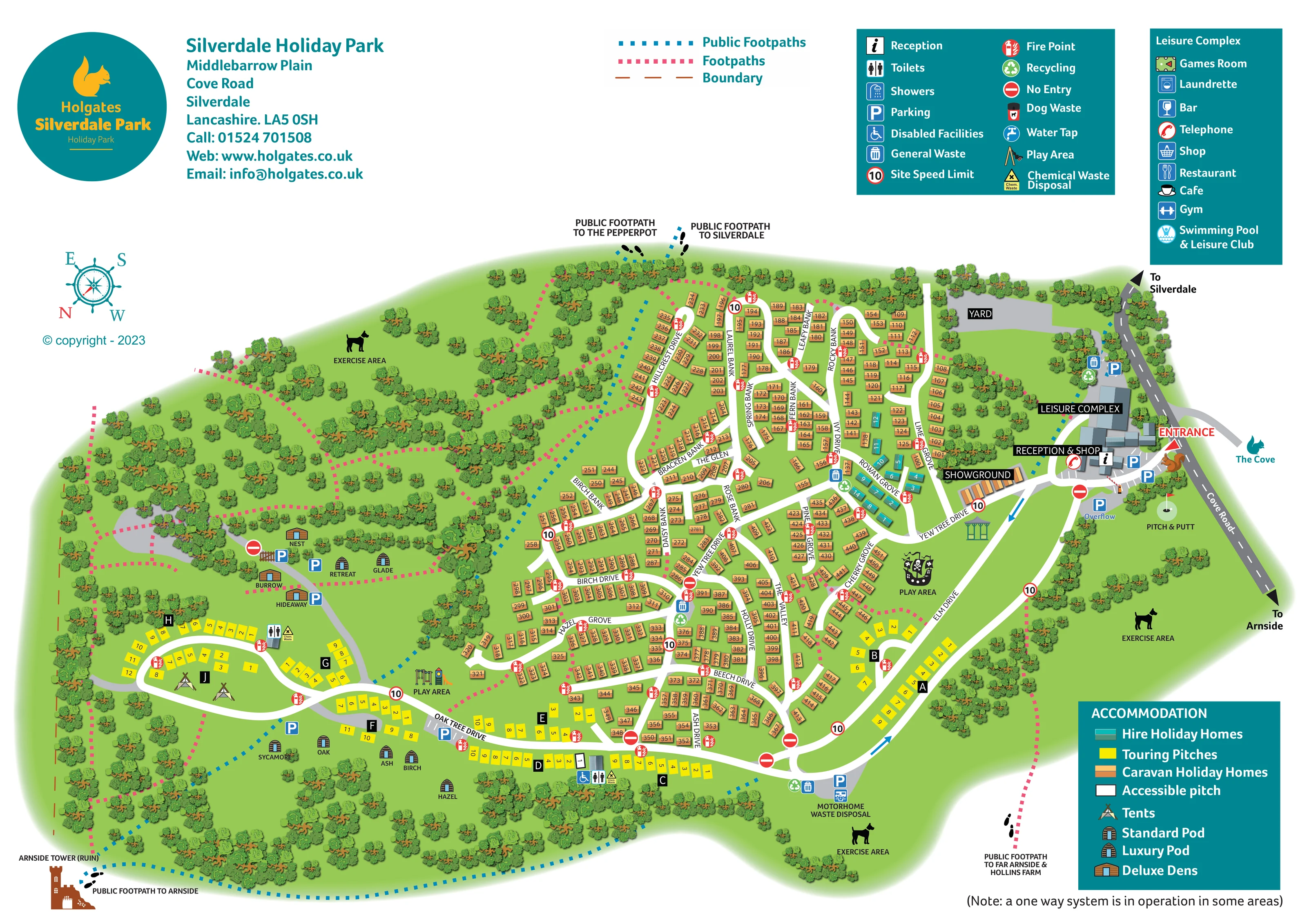
Extensive illustrated woodland surrounds the accommodation, with especially broad tree-filled areas to the left and along the lower boundary, broken by lawns, glamping clearings and walking routes.
ILLUSTRATED PARK MAP · P300
Middlebarrow Plain, Cove Road, Silverdale · United Kingdom
 Enlarge the map ↗
A SENSE OF THE PLACE
Silverdale Holiday Park is based at Middlebarrow Plain, Cove Road, Silverdale. Silverdale lies in the Arnside and Silverdale National Landscape with views over Morecambe Bay. The park offers touring, camping, glamping and holiday-home hire or ownership.
Facilities on this park include an indoor swimming complex, bowling, soft play and food outlets.
LOOK CLOSER
Extensive illustrated woodland surrounds the accommodation, with especially broad tree-filled areas to the left and along the lower boundary, broken by lawns, glamping clearings and walking routes.
An illustrated ruin is labelled outside the lower-left park edge beside the public footpath to Arnside.
A labelled reception and shop building anchors the entrance cluster beside Cove Road.
A substantial illustrated building stands immediately behind reception. Its dedicated information panel lists a swimming pool and leisure club, gym, games room, laundrette, bar, telephone, shop, restaurant and café, without showing their individual internal positions.
Two labelled play areas use recognisable equipment drawings: swings and a slide near the western touring area, and a pirate-ship feature beside Elm Drive. A small shelter-like structure is also illustrated near Yew Tree Drive.
A labelled pitch-and-putt area with a golf flag occupies the lawn beside the entrance and Cove Road.
Three peripheral exercise areas are labelled and marked with dog silhouettes, in the upper-left woodland, eastern lawn and lower-right clearing.
Service buildings in the western and southern touring areas have toilet and chemical-waste symbols. A wheelchair symbol identifies disabled facilities at the southern block.
A labelled reception and shop building anchors the entrance cluster beside Cove Road.
A substantial illustrated building stands immediately behind reception. Its dedicated information panel lists a swimming pool and leisure club, gym, games room, laundrette, bar, telephone, shop, restaurant and café, without showing their individual internal positions.
Two labelled play areas use recognisable equipment drawings: swings and a slide near the western touring area, and a pirate-ship feature beside Elm Drive. A small shelter-like structure is also illustrated near Yew Tree Drive.
A labelled pitch-and-putt area with a golf flag occupies the lawn beside the entrance and Cove Road.
Three peripheral exercise areas are labelled and marked with dog silhouettes, in the upper-left woodland, eastern lawn and lower-right clearing.
Service buildings in the western and southern touring areas have toilet and chemical-waste symbols. A wheelchair symbol identifies disabled facilities at the southern block.
A specifically labelled motorhome waste-disposal point lies beside the lower entrance loop, with parking, waste and recycling symbols nearby.
Parking is marked around reception, the leisure complex, touring areas and glamping clearings; overflow parking is labelled beside the entrance loop.
Grouped bin and recycling symbols appear at several road junctions and near the main facilities.
Repeated red fire-point icons are distributed through the accommodation roads and touring sections.
A telephone symbol is positioned at the reception building.
A labelled row of orange display units sits just inside the entrance, beside Yew Tree Drive.
A grey yard area is labelled beyond the leisure complex near Cove Road.
The general legend includes showers, water taps and dog-waste points. Their entries explain the symbol vocabulary, but clear individual positions are not established from this view.
Extensive illustrated woodland surrounds the accommodation, with especially broad tree-filled areas to the left and along the lower boundary, broken by lawns, glamping clearings and walking routes.
An illustrated ruin is labelled outside the lower-left park edge beside the public footpath to Arnside.
Blue dotted routes connect towards Arnside, Silverdale and the Pepperpot. A further labelled public-footpath connection leads towards Far Arnside and Hollins Farm.
Pink dotted paths weave through woodland, connect accommodation clearings and extend around parts of the park perimeter.
A red entrance arrow marks arrival from Cove Road. External arrows point towards Silverdale and Arnside, while The Cove is identified beyond the entrance.
Blue directional arrows, no-entry symbols and repeated speed-limit symbols support vehicle wayfinding. A printed note states that a one-way system operates in some areas.
The park's wider setting is the Arnside and Silverdale National Landscape, with views over Morecambe Bay; the bay itself is not drawn on this plan.
READING THE MAP
This illustrated map of Silverdale Holiday Park brings a large, mixed-accommodation site into one readable landscape-format plan. Set at Middlebarrow Plain in Silverdale, Lancashire, the park is shown as a network of caravan-home neighbourhoods surrounded by woodland, grassy clearings and walking routes. The entrance from Cove Road leads straight to reception, the shop and leisure complex, giving arriving visitors an immediate point of reference.
Colour does much of the organisational work. Orange caravan holiday homes fill the central roads, teal identifies hire homes near Rowan Grove, and yellow touring pitches follow the southern edge and western loop. Timber-style drawings distinguish pods and Deluxe Dens tucked into quieter clearings. Beyond finding accommodation, visitors can locate play areas, pitch and putt, dog-exercise areas and practical touring services.
The design also connects the park to its surroundings. Dotted paths and labelled exits point towards Silverdale, Arnside, the Pepperpot and Hollins Farm, while an illustration of Arnside Tower adds a memorable landmark at the edge of the plan.
The single-page plan places the main entrance on the right, where Cove Road passes reception, the shop and the illustrated leisure complex. Parking symbols surround this arrival hub, with an overflow area just inside the park. A showground row and pitch-and-putt lawn provide further landmarks close to the entrance.
From here, white roads spread into a substantial network of named drives, banks and groves. Orange caravan holiday homes line the central neighbourhoods, while a smaller teal hire-home group occupies Rowan Grove. Yellow touring sections run along Oak Tree Drive and the lower entrance loop, then curve into the western camping area. Section letters and pitch numbers provide a second level of navigation beneath the road names. The map also singles out an accessible pitch and service blocks with toilet, chemical-waste and disabled-facility symbols.
Glamping has a different visual treatment. Rounded pods and pitched-roof dens sit among trees and open grass, with names such as Nest, Burrow, Hideaway, Retreat and Glade. Two labelled play areas include a conventional equipment drawing and a distinctive pirate ship. Three dog-exercise areas occupy peripheral lawns, and motorhome waste disposal is clearly named beside the lower road loop.
Pink dotted footpaths thread through the woodland, while blue dotted public routes lead towards nearby destinations. Footprint markers emphasise walking exits, and Arnside Tower is drawn as a ruin beyond the lower-left boundary. Teal information panels explain accommodation, facilities and the leisure complex, whose listed amenities include swimming, a gym, games room and food outlets. The compass, directional arrows and no-entry symbols complete the route hierarchy without requiring a north-up layout.
KEEP EXPLORING
Chosen for shared landscapes, accommodation or facilities.
 Explore the map ↗
United Kingdom
Trevornick’s colour-coded park map, with mixed accommodation, fishing ponds, golf and wooded trails.
 Explore the map ↗
United Kingdom
Woodland-framed Barnsoul map with mixed accommodation, shared facilities and paw-marked walking routes.
 Explore the map ↗
United Kingdom
A colour-zoned coastal park map with touring areas, woodland trails, ponds and a leisure club.
Features may come from the sample artwork, its key or published park information. Approximate numbers describe the drawing and may cover only part of a park. They are intended to help you compare map examples. Current facilities and booking information should be checked with the park.
LET’S MAP YOUR PARK
For a map quotation, find your park and draw a rough boundary around it. The area you select helps us work out the design time and price.
Draw your park for a quote ↗Or talk to our map designers
01751 473136