
Tree belts and planted boundaries
Dense illustrated tree canopies cover the north and north-west, while shrubs and hedges edge the approach road and separate parts of the pitch layout.
ILLUSTRATED PARK MAP · P299
Silvercraigs Caravan Park, Silvercraigs Road, Kirkcudbright · United Kingdom
 Enlarge the map ↗
A SENSE OF THE PLACE
Silvercraigs Caravan Park provides grass and hardstanding pitches in Kirkcudbright. Electric connections and Wi-Fi are available, with options for tents and touring visitors.
Heated showers and toilets support stays. A shared cookhouse provides covered cooking space, a sink, fridge and phone charging, offering a useful shelter in wet weather. The map helps visitors locate pitches and these shared facilities.
LOOK CLOSER
Dense illustrated tree canopies cover the north and north-west, while shrubs and hedges edge the approach road and separate parts of the pitch layout.
Open green lawns contrast with the wooded edge. A brown post-and-rail fence follows the southern boundary and separates the neighbouring play park.
An information symbol marks the blue-roofed building cluster immediately west of the entrance.
A shopping-trolley symbol identifies the shop beside reception near the entrance.
Toilet and shower symbols sit over the entrance-side facilities buildings.
Pot-wash symbols appear at the main facilities block and at a separate small blue-roofed structure on the western end of the central camping island.
Repeated paired service symbols are distributed across the western touring area, central pitch rows, entrance-side junction and eastern camping lawn.
Green bin symbols recur around the park, with a grouped green, brown and blue bin station beside the central eastern route. The legend calls the bin symbol General Waste; separate waste streams are not labelled.
An information symbol marks the blue-roofed building cluster immediately west of the entrance.
A shopping-trolley symbol identifies the shop beside reception near the entrance.
Toilet and shower symbols sit over the entrance-side facilities buildings.
Pot-wash symbols appear at the main facilities block and at a separate small blue-roofed structure on the western end of the central camping island.
Repeated paired service symbols are distributed across the western touring area, central pitch rows, entrance-side junction and eastern camping lawn.
Green bin symbols recur around the park, with a grouped green, brown and blue bin station beside the central eastern route. The legend calls the bin symbol General Waste; separate waste streams are not labelled.
Red extinguisher symbols mark several locations around the touring and camping areas.
Black picnic-table silhouettes are scattered through the central camping island and eastern lawn.
Play equipment is illustrated outside the park's south-western fence, with a labelled route towards the municipal play park.
A timber-style ENTRANCE sign, red arrival arrow and striped barrier identify the access from the northern road.
Broad white routes curve around the central camping island and lower touring rows, with a western branch towards the play park.
Three red-rimmed signs displaying 5 punctuate the internal routes. No unit is printed beside them.
An arrow on the road at the eastern edge points towards the town.
A grey route edged in dark green is labelled Track and curves through the wooded northern part of the illustration towards the approach road.
Dense illustrated tree canopies cover the north and north-west, while shrubs and hedges edge the approach road and separate parts of the pitch layout.
Open green lawns contrast with the wooded edge. A brown post-and-rail fence follows the southern boundary and separates the neighbouring play park.
Published park information describes covered cooking space with a sink, fridge and phone charging. The artwork does not explicitly label a cookhouse.
Published park information mentions electric connections and Wi-Fi; neither is separately keyed or located on this map.
READING THE MAP
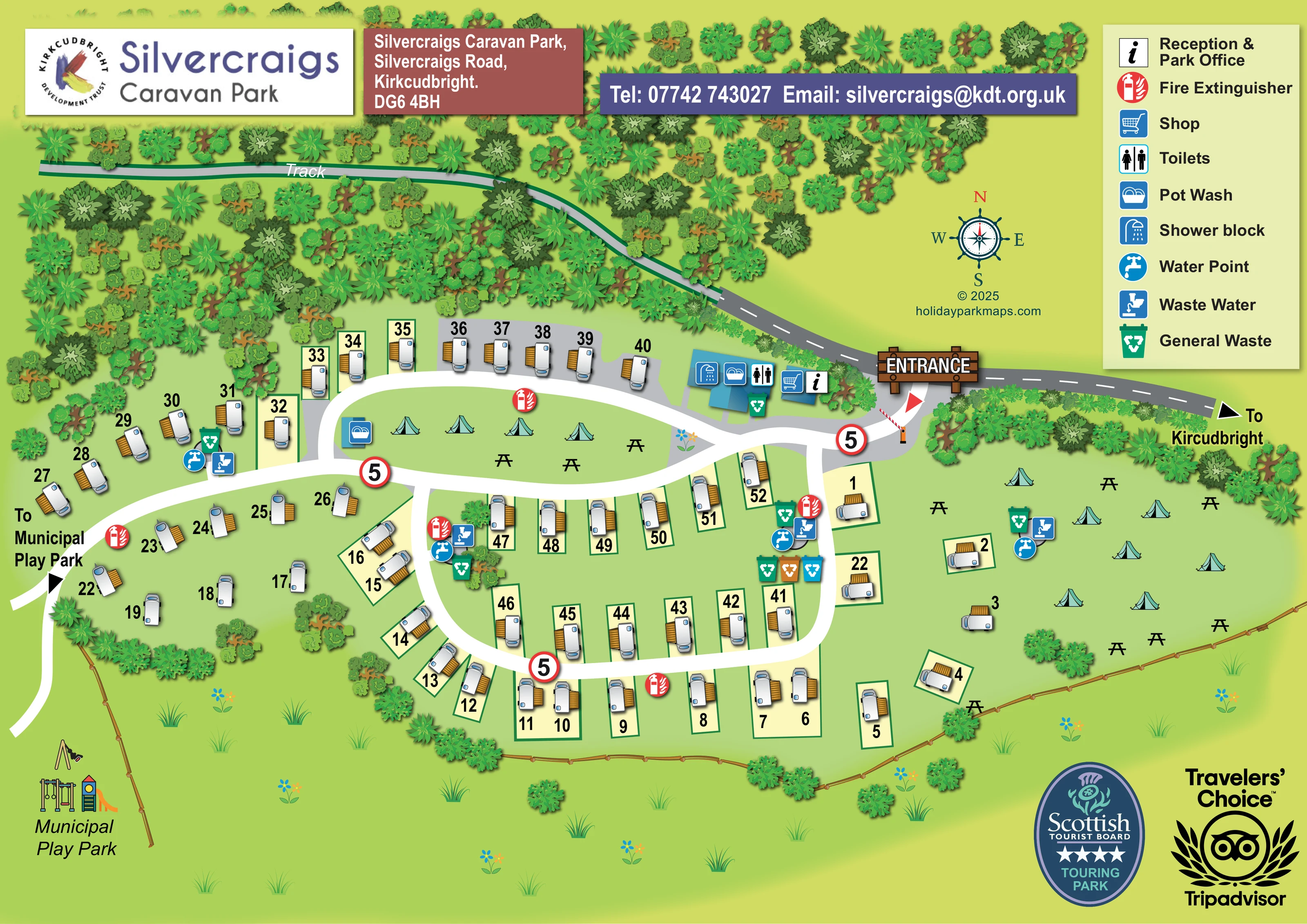
This illustrated map of Silvercraigs Caravan Park in Kirkcudbright brings a compact touring and camping layout into a single landscape-format plan. Numbered caravan pitches follow curving internal routes, while tent illustrations distinguish an elongated central grass island and a larger open lawn to the east. A dense belt of trees frames the northern side, with a labelled track running through the greenery and timber fencing defining the lower boundary.
The arrival point is particularly prominent: a timber-style entrance sign, red arrow and striped barrier lead visitors towards reception, the shop and the main washing facilities. Repeated water, waste-water, bin and fire-extinguisher symbols make shared services easy to locate across the accommodation areas. Picnic tables and the neighbouring municipal play park add useful everyday landmarks.
The artwork combines large pitch numbers with blue facility pictograms and a clearly separated legend. Park branding and contact panels sit above the plan, leaving the route network and accommodation groups as the main visual focus. It is a useful sample for touring parks that need to explain both numbered pitches and less formal camping space.
The map is arranged around a signed entrance on the northern approach road, towards the right-hand side of the page. Immediately to its west, blue-roofed buildings carry symbols for reception and the park office, a shop, toilets, showers and pot washing. A striped barrier and red arrow reinforce the arrival point without requiring a long written instruction.
Inside the park, broad white routes create an elongated upper circuit and a rounded lower loop, with connecting branches between them. Caravan illustrations follow these curves in a mixture of closely arranged rows and looser grass-pitch groups. Pale cream rectangles with dark-green outlines distinguish many individual pitches, while grey areas indicate sections of hardstanding. Large black numbers remain visually separate from the small accommodation illustrations.
Tent symbols and picnic-table silhouettes occupy the central grass island and eastern lawn. A separate pot-wash symbol appears at the western end of the central island. Water and waste-water points, waste bins and red fire-extinguisher markers recur beside the pitch groups and camping areas. Three circular signs displaying 5 sit along the internal routes.
Beyond the accommodation, dense tree canopies fill the northern edge around a labelled track. A town-direction arrow follows the approach road eastwards, while a western route points towards the municipal play park, illustrated outside the fence with swings and climbing equipment. Shrubs, timber fencing, flowers and grass tufts define the softer edges of the plan.
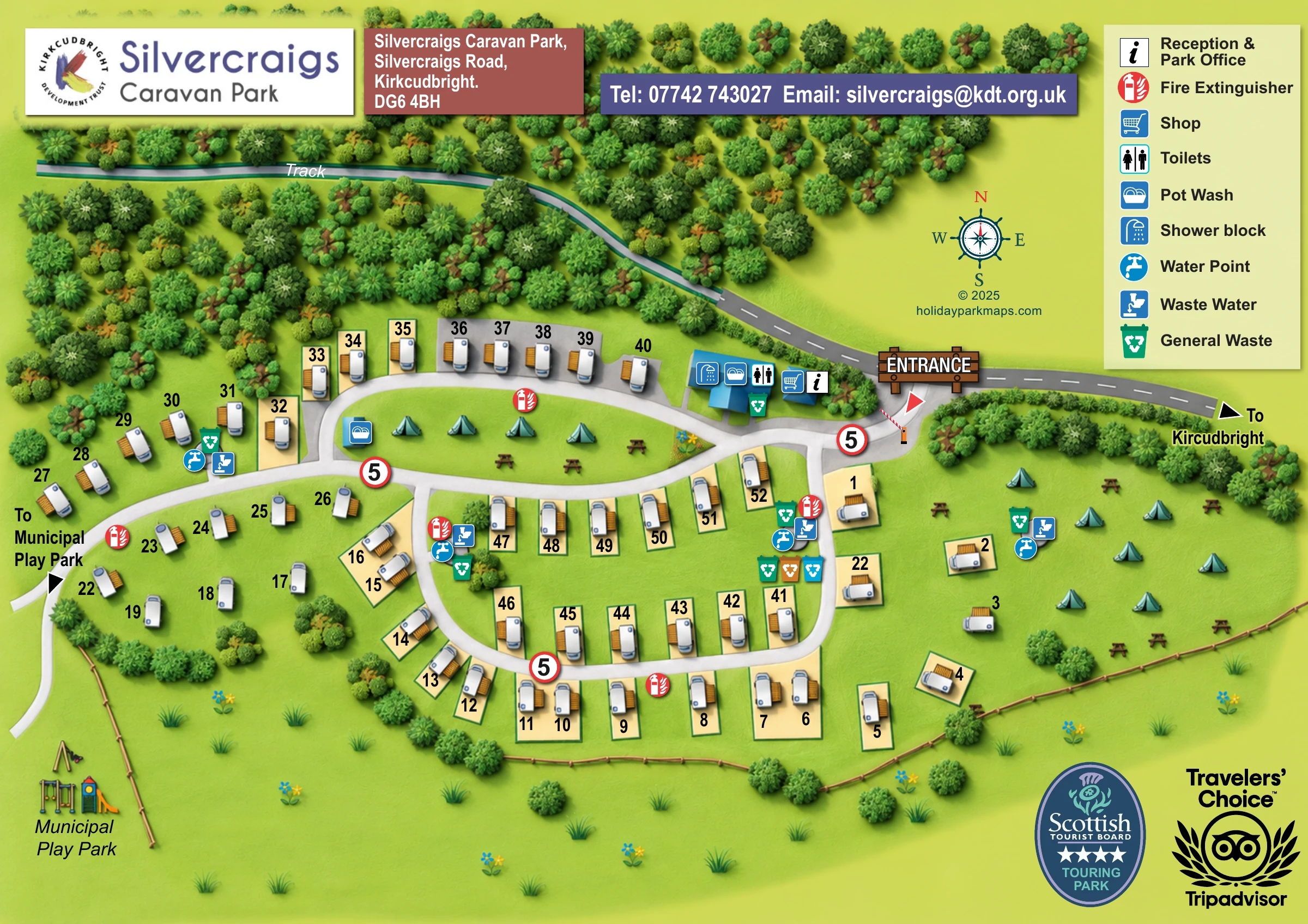
A tall legend occupies the upper-right corner, supported by a compass rose. The upper branding panels and lower-right tourism badges complete the page composition. The enlarged views show overlapping portions of this same artwork, rather than additional park sections.
 Enlarge this map ↗
KEEP EXPLORING
Chosen for shared landscapes, accommodation or facilities.
 Explore the map ↗
United Kingdom
A wooded Allerton park plan with colour-coded neighbourhoods, touring pitches and a central facilities hub.
 Explore the map ↗
United Kingdom
Colour-coded pitches, named log cabins and a woodland trail at Alpine Grove, Somerset.
 Explore the map ↗
United Kingdom
Woodland camping, lodges, lakes and colour-coded bike trails at Avon Tyrrell Outdoor Centre.
Features may come from the sample artwork, its key or published park information. Approximate numbers describe the drawing and may cover only part of a park. They are intended to help you compare map examples. Current facilities and booking information should be checked with the park.
LET’S MAP YOUR PARK
For a map quotation, find your park and draw a rough boundary around it. The area you select helps us work out the design time and price.
Draw your park for a quote ↗Or talk to our map designers
01751 473136