
Woodland and planted boundaries
Dense illustrated trees cover much of the western grounds, with tree belts and hedges dividing accommodation areas and edging the park.
ILLUSTRATED PARK MAP · P305
Smytham Holiday Park, Little Torrington, Devon · United Kingdom
 Enlarge the map ↗
A SENSE OF THE PLACE
Smytham is a family-run holiday park at Little Torrington in North Devon, set within the grounds of a former manor. Camping, touring, glamping pods, log cabins and holiday home ownership provide a range of ways to stay.
The grounds include a seasonal heated outdoor swimming pool, a games room and spaces for outdoor games. Selected lodges have private decking and hot tubs, while the park map helps visitors find their way between accommodation and shared facilities.
LOOK CLOSER
Dense illustrated trees cover much of the western grounds, with tree belts and hedges dividing accommodation areas and edging the park.
Two irregular pale-blue water bodies sit within the wooded western grounds.
A large, unlabelled green space lies north of the upper hard-standing rows, enclosed by planted boundaries.
A large timber-style ENTRANCE sign and red arrow identify arrival from the right-hand edge of the plan.
A small entrance-side loop is labelled Late Arrivals.
An R symbol marks a blue-roofed building at the central junction beside the western lodge area.
An information symbol marks a building on the route between reception, The Paddock and the recreation facilities.
The Sales Office is labelled immediately south of the swimming-pool enclosure.
A large timber-style ENTRANCE sign and red arrow identify arrival from the right-hand edge of the plan.
A small entrance-side loop is labelled Late Arrivals.
An R symbol marks a blue-roofed building at the central junction beside the western lodge area.
An information symbol marks a building on the route between reception, The Paddock and the recreation facilities.
The Sales Office is labelled immediately south of the swimming-pool enclosure.
A blue rectangular pool and adjacent narrow blue rectangle appear within a peach-coloured, stone-edged enclosure near the centre.
Parasol-covered picnic-table symbols mark seating within the pool enclosure.
Shower and toilet symbols identify facilities at the eastern edge of the pool enclosure.
A washing-up symbol marks a separate blue-roofed building on the western side of the touring area.
Illustrated swings and a slide stand beside the tourist-information building, west of The Paddock.
A pool-table symbol identifies a small building south of the play area.
Repeated red extinguisher symbols mark points along the western accommodation roads and near reception.
Red-ringed signs displaying 10 appear at several road junctions and approach sections.
A prominent grey-roofed building is labelled The Manor House beside a curving southern access road; its visitor function is not specified.
Dense illustrated trees cover much of the western grounds, with tree belts and hedges dividing accommodation areas and edging the park.
Two irregular pale-blue water bodies sit within the wooded western grounds.
An orange dashed route with black footprint symbols runs along the southern woodland edge and is labelled Footpath to Tarka Trail.
A dog symbol and paw prints identify an exercise area near the western end of the woodland footpath.
A large, unlabelled green space lies north of the upper hard-standing rows, enclosed by planted boundaries.
READING THE MAP
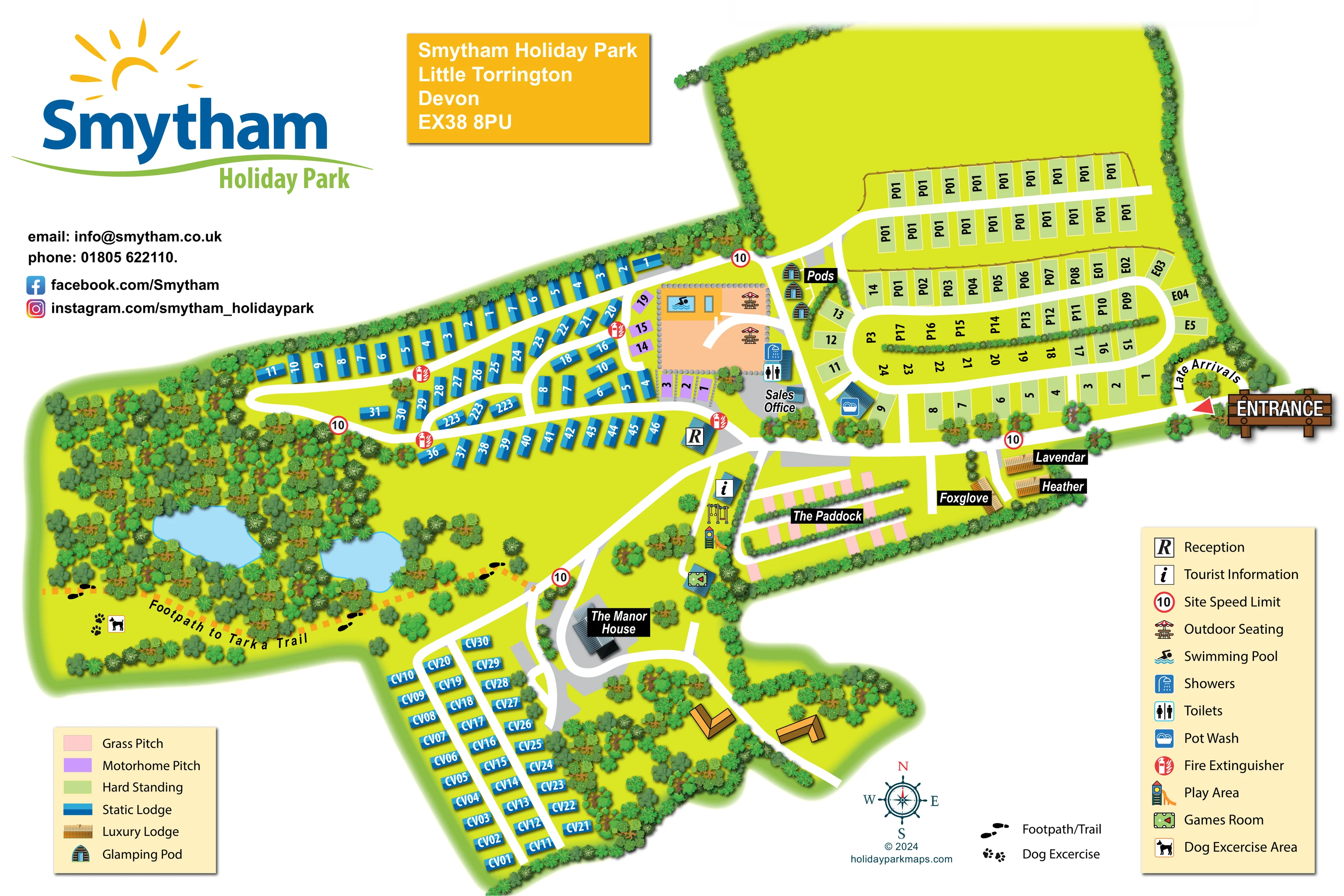
This illustrated map of Smytham Holiday Park in Little Torrington, Devon brings a varied country-park layout into one clear, colourful plan. Static lodges, touring hard standings, motorhome pitches, grass pitches and glamping pods each have a distinct visual treatment, helping visitors recognise their accommodation area before following the internal roads. Three named luxury lodges add another recognisable group near the entrance.
The setting is an important part of the artwork. Dense woodland surrounds two ponds on the western side, and a dashed footpath leads towards the Tarka Trail, with a dog exercise area marked nearby. Elsewhere, the map shows the swimming pool, outdoor seating, play area and games room alongside practical destinations such as reception, tourist information and washing facilities.
A large Smytham logo, golden address panel and timber-style entrance sign give the page a strong park identity. Separate accommodation and facility keys keep the busy plan understandable without stripping away its landscape character. This sample is particularly relevant to mixed-accommodation parks that need to explain both their arrival routes and the relationship between visitor facilities, planted grounds and places to stay.
Arrival is shown at the right-hand edge, where a timber-style entrance sign and red arrow lead into the main internal road. A small loop labelled Late Arrivals sits just inside this point. From here, the road runs towards reception and branches into the main accommodation areas. Pale-green hard standings occupy the eastern side in parallel rows and around an elongated loop, with a substantial open lawn beyond the upper pitches.
The central swimming-pool enclosure is picked out in peach, with blue water, parasol-covered seating and a stone-like perimeter. Shower and toilet symbols mark its eastern side, while a separate pot-wash building stands beside the touring roads. Purple motorhome pitches wrap around part of the pool area, and three curved-front pods form a short neighbouring row. The Sales Office is labelled immediately below the enclosure.
Blue static lodges follow the western lanes and form a separate compact block in the south. Pink grass pitches fill The Paddock, where narrow hedges divide the rows. Nearby, golden timber illustrations identify the luxury lodges Heather, Foxglove and Lavendar. Tourist information, swings, a slide and the games room occupy a small recreation corridor west of The Paddock. The Manor House provides a larger architectural landmark beside the southern road.
On the western side, layered tree symbols surround two ponds. An orange dashed route, punctuated by black footprints, follows the woodland edge towards the Tarka Trail; dog and paw symbols identify the exercise area. Two cream legends explain accommodation colours and facility icons, with a compass and separate walking-symbol key below the plan. The enlarged detail views show portions of this same artwork, rather than separate map variants.
KEEP EXPLORING
Chosen for shared landscapes, accommodation or facilities.
 Explore the map ↗
United Kingdom
Woodland-framed Barnsoul map with mixed accommodation, shared facilities and paw-marked walking routes.
 Explore the map ↗
United Kingdom
A colour-zoned coastal park map with touring areas, woodland trails, ponds and a leisure club.
 Explore the map ↗
United Kingdom
Woodland holiday-park map with named accommodation areas, touring loops and illustrated recreation facilities.
Features may come from the sample artwork, its key or published park information. Approximate numbers describe the drawing and may cover only part of a park. They are intended to help you compare map examples. Current facilities and booking information should be checked with the park.
LET’S MAP YOUR PARK
For a map quotation, find your park and draw a rough boundary around it. The area you select helps us work out the design time and price.
Draw your park for a quote ↗Or talk to our map designers
01751 473136