
Tree belts and hedges
Large stylised trees frame much of the western and eastern boundary. Smaller repeated shrubs define the roadside edge, northern boundary and several accommodation groups.
ILLUSTRATED PARK MAP · P601
Tedburn St Mary, Exeter, Devon · United Kingdom
 Enlarge the map ↗
A SENSE OF THE PLACE
Springfield Retreat is based at Tedburn St Mary, Exeter, Devon. The park lies in countryside near Tedburn St Mary with access from the A30. Holiday homes and lodges are offered for ownership.
The operator describes gated grounds, a heated outdoor pool and a dog-friendly policy.
LOOK CLOSER
Large stylised trees frame much of the western and eastern boundary. Smaller repeated shrubs define the roadside edge, northern boundary and several accommodation groups.
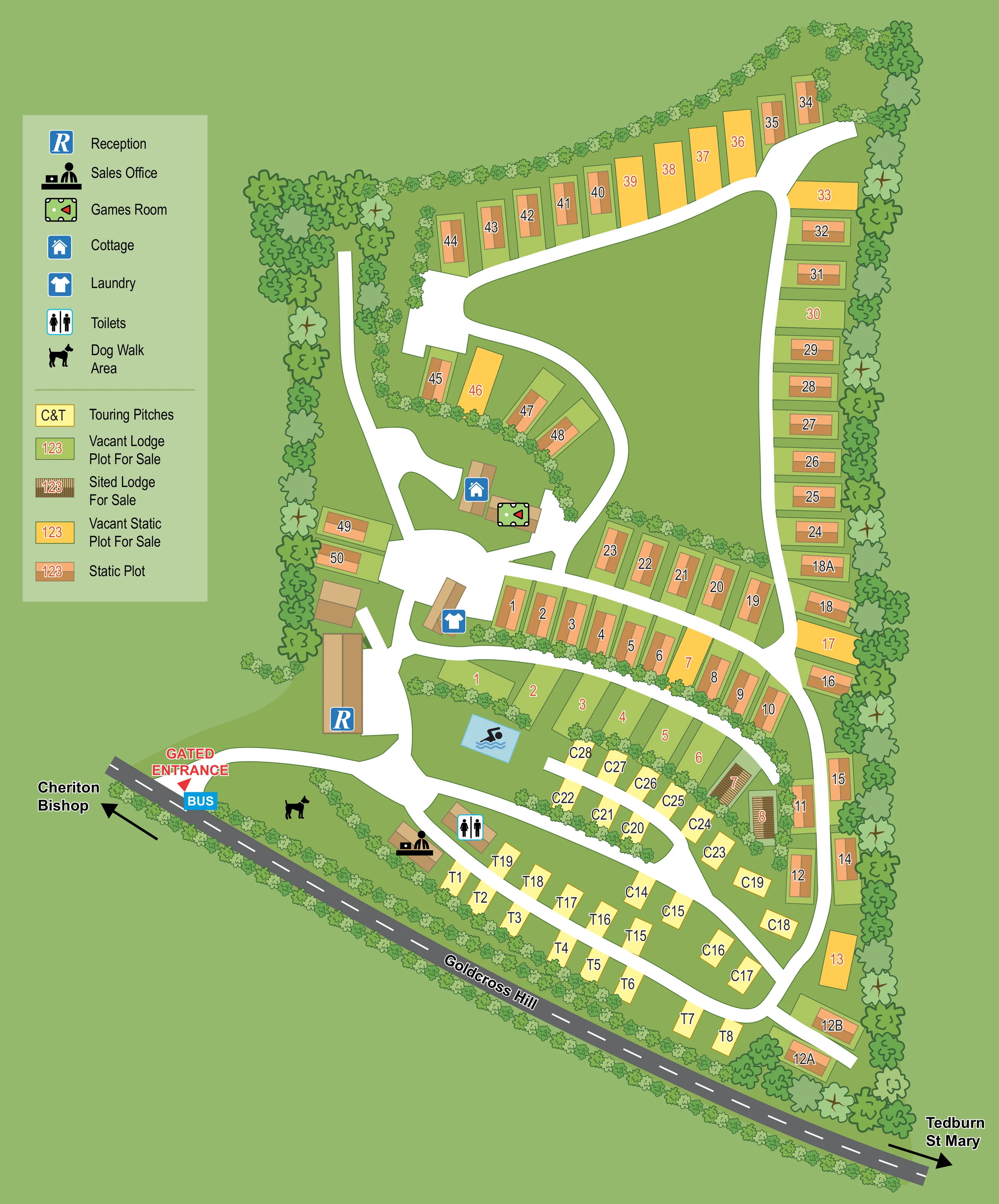
An extensive unlabelled green area occupies the upper centre within the curving road network. No specific recreational use is assigned to it.
A long tan building with a blue R symbol stands just inside the entrance, beside the main internal junction.
A desk-and-person pictogram marks a building near the entrance and lower touring area.
A pool-table pictogram marks the games room beside the cottage, west of the central accommodation rows.
A blue shirt symbol identifies a building near reception and the central static accommodation.
A toilet pictogram marks a building beside the sales office and lower touring pitches.
A light-blue rectangle with a swimmer symbol marks a pool on the green space below the vacant lodge plots. It is visible on the plan but omitted from the displayed legend.
A long tan building with a blue R symbol stands just inside the entrance, beside the main internal junction.
A desk-and-person pictogram marks a building near the entrance and lower touring area.
A pool-table pictogram marks the games room beside the cottage, west of the central accommodation rows.
A blue shirt symbol identifies a building near reception and the central static accommodation.
A toilet pictogram marks a building beside the sales office and lower touring pitches.
A light-blue rectangle with a swimmer symbol marks a pool on the green space below the vacant lodge plots. It is visible on the plan but omitted from the displayed legend.
A black dog silhouette identifies a green area between the entrance, sales office and roadside hedge.
A red arrow and prominent red-and-white label mark the entrance from Goldcross Hill on the lower-left side of the plan.
A blue BUS label appears beside the roadside entrance. No route, timetable or service frequency is specified.
The named grey road runs diagonally along the lower boundary, with arrows towards Cheriton Bishop on the left and Tedburn St Mary on the right.
Broad white lanes connect the entrance hub, lower touring loops, central accommodation rows and long northern and eastern perimeter route.
Large stylised trees frame much of the western and eastern boundary. Smaller repeated shrubs define the roadside edge, northern boundary and several accommodation groups.
An extensive unlabelled green area occupies the upper centre within the curving road network. No specific recreational use is assigned to it.
READING THE MAP
This map of Springfield Retreat in Devon combines everyday visitor wayfinding with a clear picture of the park's accommodation layout. Set beside Goldcross Hill near Tedburn St Mary, the illustrated plan shows a long, tree-framed site reached through a prominently marked gated entrance. White internal roads lead from reception into distinct groups of static caravan plots, lodge plots and touring pitches, with village direction arrows helping to place the entrance in its local setting.
The design has a practical sales dimension as well as a visitor role. Its legend distinguishes vacant static and lodge plots from static plots and sited lodges marked for sale, using colour and roof treatments rather than lengthy labels across the plan. Facility symbols pick out the sales office, games room, cottage, laundry, toilets and dog walk area, while a blue swimming-pool symbol adds an immediate visual landmark.
Muted greens, repeated hedges and large boundary trees convey the countryside setting without obscuring the numbered accommodation. This is a useful example for parks needing one coherent plan to explain arrival, facilities and a mixed accommodation offer.
The portrait plan places a large two-part legend on the left and the elongated park layout across the centre and right. Goldcross Hill runs diagonally along the lower boundary, with arrows pointing towards Cheriton Bishop and Tedburn St Mary. A red arrow identifies the gated entrance, accompanied by a blue BUS marker. Just inside, reception occupies a long tan building beside the main junction; the sales office and toilet building sit nearer the lower touring area.
Broad white lanes divide the accommodation into readable groups. Pale-yellow touring pitches form rows and loops along the roadside end of the park, with C- and T-prefixed labels. Above them, a curved lodge grouping includes green vacant plots and striped sited-lodge symbols. A light-blue swimming-pool marker sits on adjacent green space. Static accommodation extends across short central rows and up the eastern edge before following the northern boundary. Peach-and-brown unit symbols alternate with golden-yellow vacant static plots.
The cottage and games room occupy a small cluster to the west of the central accommodation, with the laundry farther south near reception. A dog silhouette marks the dog walk area inside the roadside hedge. The upper road network curves around a substantial unlabelled green space, keeping the northern portion visually open.
Stylised trees frame the site, while smaller shrubs delineate boundaries and separate rows. The legend explains both facility symbols and accommodation status, allowing the plan to serve navigation and sales enquiries together. The artwork is a single complete plan; the enlarged views show overlapping details of that same composition, not separate park sections.
KEEP EXPLORING
Chosen for shared landscapes, accommodation or facilities.
 Explore the map ↗
United Kingdom
Illustrated Anglesey park map with static caravans, touring loops, camping, sports courts and a perimeter dog walk.
 Explore the map ↗
United Kingdom
Woodland-framed Barnsoul map with mixed accommodation, shared facilities and paw-marked walking routes.
 Explore the map ↗
United Kingdom
Colour-coded park map with numbered holiday-home areas, touring pitches, camping and an illustrated leisure hub.
Features may come from the sample artwork, its key or published park information. Approximate numbers describe the drawing and may cover only part of a park. They are intended to help you compare map examples. Current facilities and booking information should be checked with the park.
LET’S MAP YOUR PARK
For a map quotation, find your park and draw a rough boundary around it. The area you select helps us work out the design time and price.
Draw your park for a quote ↗Or talk to our map designers
01751 473136