
Wooded edges and planted buffers
Dense stylised trees line the northern and eastern boundaries, surround the western approach and separate some accommodation and amenity areas.
ILLUSTRATED PARK MAP · P602
Springhouse Boutique Holiday Park, Slaley, Hexham, Northumberland · United Kingdom
 Enlarge the map ↗
A SENSE OF THE PLACE
Springhouse Boutique Holiday Park is a holiday home park in the Northumberland countryside near Slaley and Hexham. Caravan and lodge accommodation sits within a rural setting suited to relaxed breaks.
The operator describes a bar and restaurant as part of the park's social facilities. Selected accommodation includes outdoor seating or a hot tub; the map helps visitors understand the layout of the holiday homes and shared spaces.
LOOK CLOSER
Dense stylised trees line the northern and eastern boundaries, surround the western approach and separate some accommodation and amenity areas.
A broad grassy foreground contains play, picnic and games features, scattered trees and decorative flower motifs.
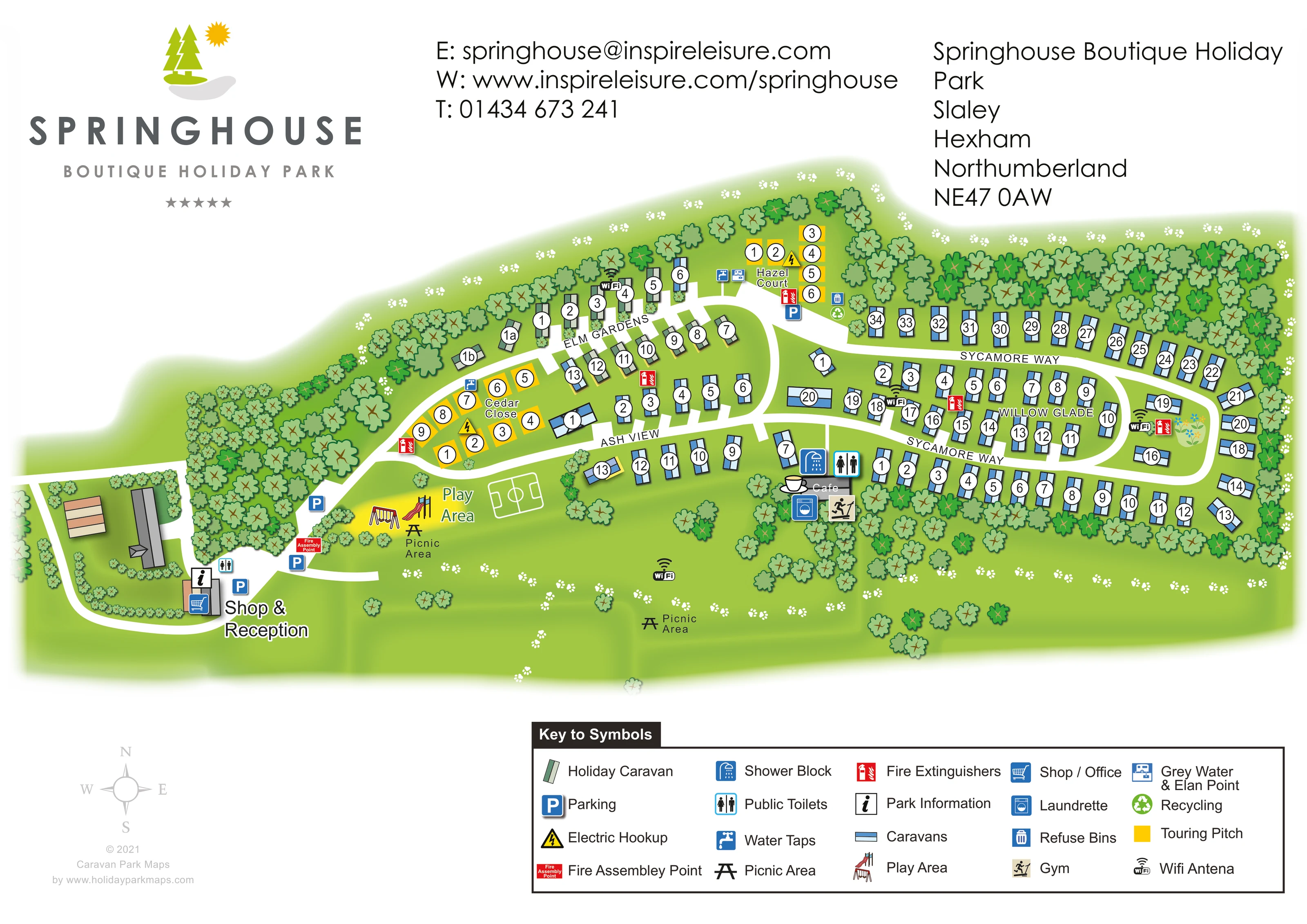
Labelled arrival building at the lower-left entrance, accompanied by shop, information, toilet and parking symbols.
A cup illustration and Café label identify the shared facility cluster beside the lower central road.
Gym symbol appears beside the café and other shared facilities.
Washing-machine symbol locates the laundrette in the café-side facility cluster.
Shower and toilet symbols are shown beside the café; another public toilet symbol appears at reception.
Labelled play area on the open green near reception, illustrated with swings and a slide.
Labelled arrival building at the lower-left entrance, accompanied by shop, information, toilet and parking symbols.
A cup illustration and Café label identify the shared facility cluster beside the lower central road.
Gym symbol appears beside the café and other shared facilities.
Washing-machine symbol locates the laundrette in the café-side facility cluster.
Shower and toilet symbols are shown beside the café; another public toilet symbol appears at reception.
Labelled play area on the open green near reception, illustrated with swings and a slide.
A small white football-style pitch outline sits beside the play area; it has no separate text label.
Two labelled picnic locations are marked with table symbols, one beside the play area and another on the southern green.
Blue parking symbols identify spaces around reception and the arrival road, with another near Hazel Court.
An information symbol is positioned at the shop and reception.
Yellow electrical symbols are placed within both touring courts.
Blue tap symbols appear near Cedar Close and Hazel Court.
A disposal symbol is shown near Hazel Court; the legend labels it 'Grey Water & Elan Point'.
Refuse and recycling symbols are grouped near the eastern side of Hazel Court.
Several antenna symbols appear across the caravan areas and southern green; these mark locations rather than a coverage guarantee.
Red extinguisher symbols are distributed around the accommodation roads, and a labelled assembly point is shown near the arrival area.
Dense stylised trees line the northern and eastern boundaries, surround the western approach and separate some accommodation and amenity areas.
A broad grassy foreground contains play, picnic and games features, scattered trees and decorative flower motifs.
Elm Gardens, Ash View, Sycamore Way, Willow Glade, Cedar Close and Hazel Court organise the accommodation into recognisable neighbourhoods.
The park information describes a bar and restaurant. The artwork labels a café but does not separately identify a bar or restaurant.
READING THE MAP
This illustrated map of Springhouse Boutique Holiday Park places a tree-framed Northumberland site within a clear, visitor-friendly plan. The park is in Slaley, near Hexham, and the artwork balances its countryside character with practical information about accommodation, arrival and shared facilities.
White roads connect the shop and reception at the western entrance with named caravan neighbourhoods and two compact touring courts. Elm Gardens and Ash View lead towards the larger eastern layout around Sycamore Way and Willow Glade, while Cedar Close and Hazel Court stand out in yellow. A broad green foreground gives the play area, picnic spots and small marked games area room to read clearly.
The design combines numbered accommodation symbols with recognisable service icons, including showers, toilets, a laundrette, gym and café. Dense illustrated trees frame the site without obscuring its routes. Prominent branding above the plan and a substantial symbol key below make this a useful sample for parks needing both an attractive overview and straightforward on-site orientation.
The plan is arranged as an elongated green site, with arrival on the left and the main caravan neighbourhood extending to the right. The entrance road curves past buildings and planted boundaries before reaching the labelled shop and reception. Parking, information and toilet symbols establish this as the first visitor landmark, with a fire assembly point nearby.
From here, white roads branch through smaller accommodation groups. Cedar Close and Hazel Court contain yellow touring pitches, supported by mapped electric hookups and water points. Refuse, recycling and disposal symbols appear near Hazel Court. Elm Gardens uses green caravan symbols, while Ash View and the eastern neighbourhood use blue units. Large white number circles and named roads make the groups easy to distinguish without relying solely on colour.
In the eastern half, Sycamore Way forms an elongated loop around Willow Glade, with caravans lining both the outer edges and inner roads. A café landmark sits near the lower central junction, alongside shower, toilet, laundrette and gym symbols. Wi-Fi antenna markers and red extinguisher icons are distributed across the plan.
The southern green holds illustrated play equipment, a small football-style pitch outline and two labelled picnic areas. Dense tree belts surround the northern and eastern accommodation, while looser planting softens the recreation space. The map uses an overhead viewpoint, shaded rectangular units and decorative trees rather than realistic aerial imagery. Branding and contact information sit above the site; the compass and multi-column symbol key occupy the lower margin. The accompanying detail views enlarge this same artwork’s legend rather than showing additional park sections.
KEEP EXPLORING
Chosen for shared landscapes, accommodation or facilities.
 Explore the map ↗
United Kingdom
Woodland-framed Barnsoul map with mixed accommodation, shared facilities and paw-marked walking routes.
 Explore the map ↗
United Kingdom
A wooded, streamside park map with a linked farm, café, touring and cottage area.
 Explore the map ↗
United Kingdom
A colour-zoned coastal park map with touring areas, woodland trails, ponds and a leisure club.
Features may come from the sample artwork, its key or published park information. Approximate numbers describe the drawing and may cover only part of a park. They are intended to help you compare map examples. Current facilities and booking information should be checked with the park.
TAKE A CLOSER LOOK
View the illustrated map in detail or choose a file to download. These are sample maps; contact the park for current visitor information.


LET’S MAP YOUR PARK
For a map quotation, find your park and draw a rough boundary around it. The area you select helps us work out the design time and price.
Draw your park for a quote ↗Or talk to our map designers
01751 473136
 springhouseparkmap_large.png
 springhouseparkmap.png