
Tree and hedge boundaries
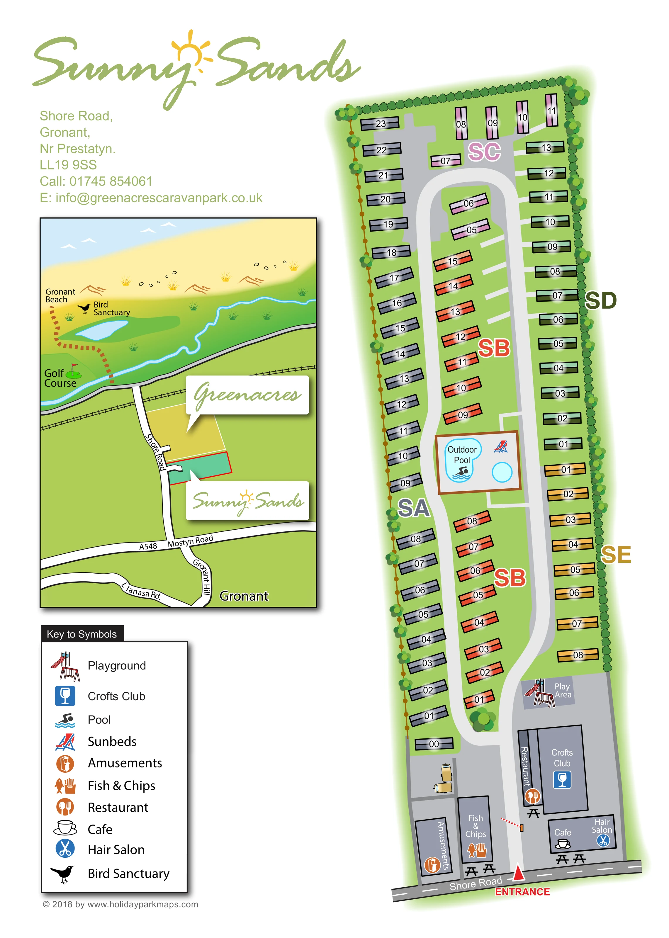
Continuous hedge symbols define the upper and right boundaries; individual round-canopied trees punctuate the left edge and selected internal spaces.
ILLUSTRATED PARK MAP · P611
Shore Road, Gronant, Nr Prestatyn · United Kingdom
 Enlarge the map ↗
A SENSE OF THE PLACE
Sunny Sands is a family-run holiday park near Gronant Beach on the North Wales coast. It is operated alongside neighbouring Greenacres, with holiday caravans and touring provision forming part of the offering.
Hardstanding touring pitches have electric connections, while holiday home ownership and rental choices are also advertised by the operator. The map helps visitors understand Sunny Sands' own layout within this coastal holiday area.
LOOK CLOSER
Continuous hedge symbols define the upper and right boundaries; individual round-canopied trees punctuate the left edge and selected internal spaces.
The location inset shows a labelled sandy beach, pale blue sea, dune-like marks and beach grasses beyond the park area.
A labelled bird sanctuary appears in the coastal inset, accompanied by a black bird symbol and illustrated wetland features.
The location inset labels a golf course and illustrates it with a green and flag; it is not shown within the main park boundary.
A winding blue watercourse and a small pond help describe the landscape between the local road and the beach in the inset.
A labelled pool enclosure sits midway along the central accommodation strip, illustrated with a shaped blue pool, a smaller circular blue feature and a swimmer symbol.
A deckchair symbol appears inside the pool enclosure and is identified as Sunbeds in the key.
A labelled play area with a slide-and-swings illustration lies beside the internal road, just beyond the entrance facilities.
A labelled pool enclosure sits midway along the central accommodation strip, illustrated with a shaped blue pool, a smaller circular blue feature and a swimmer symbol.
A deckchair symbol appears inside the pool enclosure and is identified as Sunbeds in the key.
A labelled play area with a slide-and-swings illustration lies beside the internal road, just beyond the entrance facilities.
A substantial labelled building on the right of the entrance road, marked with a blue drinks-glass symbol.
A narrow restaurant footprint adjoins Crofts Club and carries an orange cutlery symbol.
A labelled entrance-side building on the left, identified by an orange arcade-machine symbol.
A separate labelled building beside the entrance road, with a fish-and-chips pictogram.
The café occupies part of the frontage building on the right of the entrance and is marked by a cup-and-saucer symbol.
A labelled hair salon shares the frontage building with the café and uses a blue scissors symbol.
Repeated black picnic-table silhouettes appear outside the food outlets and beside the club/restaurant building.
The principal entrance is marked by a red triangle and bold red ENTRANCE lettering on Shore Road.
A red-and-white barrier arm is illustrated across the access road between the entrance buildings.
A pale road runs into the long site, divides around the central caravan strip and curves around its upper end.
Continuous hedge symbols define the upper and right boundaries; individual round-canopied trees punctuate the left edge and selected internal spaces.
The location inset shows a labelled sandy beach, pale blue sea, dune-like marks and beach grasses beyond the park area.
A labelled bird sanctuary appears in the coastal inset, accompanied by a black bird symbol and illustrated wetland features.
The location inset labels a golf course and illustrates it with a green and flag; it is not shown within the main park boundary.
A winding blue watercourse and a small pond help describe the landscape between the local road and the beach in the inset.
The inset names Shore Road, A548 Mostyn Road, Gronant Hill and Llanasa Road, with Gronant labelled below the coastal area.
A brown dotted line in the inset leads across the coastal landscape towards Gronant Beach; no route distance or detailed walking instructions are supplied.
A branded callout in the location inset identifies Greenacres separately from Sunny Sands along Shore Road.
READING THE MAP
This Sunny Sands Caravan Park map brings together a compact coastal park plan and a wider location illustration for Gronant, near Prestatyn. The main drawing follows the park’s long, narrow shape, with arrival from Shore Road at the foot of the page and numbered caravans arranged around a looping internal road. Five colour-coded sections make the accommodation rows easy to distinguish, while the outdoor pool provides a recognisable landmark partway through the site.
The entrance area receives particular attention. Crofts Club, the restaurant, amusements, fish and chips, café and hair salon are labelled within their building footprints, with a play area just beyond them. Matching pictograms connect these features to the separate symbol key.
On the left, a framed inset places Sunny Sands and neighbouring Greenacres in relation to Gronant Beach, the bird sanctuary, a golf course and local roads. The green script logo, sunny yellow accent and bright landscape colours give the page a holiday character without obscuring its practical purpose: helping visitors understand both the park layout and its coastal surroundings.
The artwork uses a portrait composition, reserving the right-hand side for the complete Sunny Sands plan and the left for branding, contact information, a location inset and the symbol key. The park is drawn as an elongated green enclosure, edged with hedges and individual trees. Pale internal roads surround a central accommodation strip and turn around its upper end.
Caravans appear as simple black-outlined rectangles, with their numbers placed over soft white highlights. Grey SA units line the left boundary; orange SB units occupy much of the centre; pink SC units gather near the top; and green SD and yellow SE rows run down the right. Large matching section letters support quick recognition without relying on unit numbers alone. Short pale access strips connect some units to the road.
The outdoor pool sits within a bordered enclosure in the middle of the plan. Its blue water shapes, swimmer symbol and deckchair distinguish it from the surrounding accommodation. Closer to Shore Road, a slide-and-swings illustration marks the play area. The entrance buildings form a clear visitor hub: amusements and fish and chips lie to the left of the access road, with Crofts Club, its adjoining restaurant, the café and hair salon to the right. Picnic-table silhouettes indicate outdoor seating, and a striped barrier marks the approach into the park.
The separate location inset broadens the picture without adding another accommodation plan. It shows the two named parks along Shore Road, connections with A548 Mostyn Road and Gronant, and an illustrated coast containing beach, bird sanctuary, golf course, pond and watercourse. A brown dotted route leads towards the beach. The legend enlargement and entrance detail are overlapping close-ups of this same page, not separate map variants.
KEEP EXPLORING
Chosen for shared landscapes, accommodation or facilities.
 Explore the map ↗
United Kingdom
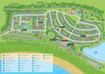
Coastal holiday-park plan with named caravan neighbourhoods, dune paths, leisure facilities and a wildlife lake.
 Explore the map ↗
United Kingdom
A colour-zoned coastal park map with touring areas, woodland trails, ponds and a leisure club.
 Explore the map ↗
United Kingdom
Colour-coded accommodation, central leisure facilities and coastal paths on an illustrated headland park map.
Features may come from the sample artwork, its key or published park information. Approximate numbers describe the drawing and may cover only part of a park. They are intended to help you compare map examples. Current facilities and booking information should be checked with the park.
TAKE A CLOSER LOOK
View the illustrated map in detail or choose a file to download. These are sample maps; contact the park for current visitor information.


LET’S MAP YOUR PARK
For a map quotation, find your park and draw a rough boundary around it. The area you select helps us work out the design time and price.
Draw your park for a quote ↗Or talk to our map designers
01751 473136