
Fishing pond
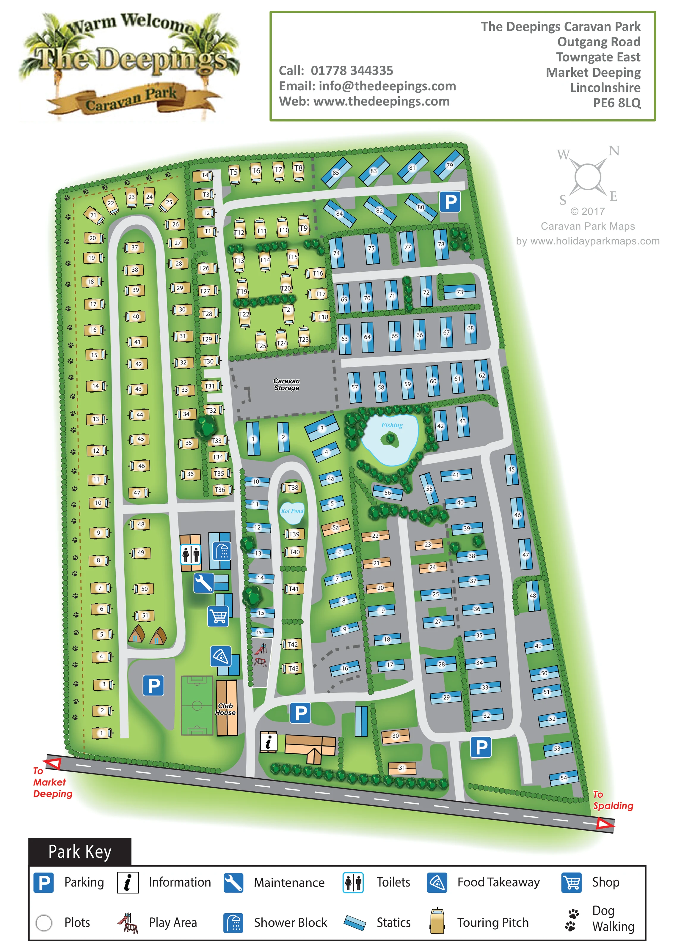
An irregular pale-blue pond labelled Fishing has a small planted island and a dense tree surround.
ILLUSTRATED PARK MAP · P618
Towngate East, Market Deeping, Lincolnshire · United Kingdom
 Enlarge the map ↗
A SENSE OF THE PLACE
The Deepings Caravan Park is a family-owned park at Market Deeping in Lincolnshire. Fishing and a range of shared recreation facilities give the grounds a varied holiday character.
The park listing describes a children's play area, shop, clubhouse, restaurant, tenpin bowling and a multiuse sports arena. The map helps visitors locate these shared spaces alongside the accommodation areas.
LOOK CLOSER
An irregular pale-blue pond labelled Fishing has a small planted island and a dense tree surround.
A smaller labelled pond lies within the elongated lower-central accommodation loop.
Continuous hedged boundaries, internal hedge divisions and clusters of fuller trees define accommodation areas and soften the pond margins.
A labelled elongated building beside the sports court and the lower western parking area.
A green rectangular court with goals, centre circle and pitch markings beside the clubhouse.
Slide and swing illustrations mark a narrow recreation space beside the lower central accommodation loop.
A shopping-trolley symbol identifies a building in the western facilities cluster.
A blue takeaway symbol marks a building immediately above the clubhouse.
A labelled elongated building beside the sports court and the lower western parking area.
A green rectangular court with goals, centre circle and pitch markings beside the clubhouse.
Slide and swing illustrations mark a narrow recreation space beside the lower central accommodation loop.
A shopping-trolley symbol identifies a building in the western facilities cluster.
A blue takeaway symbol marks a building immediately above the clubhouse.
Separate toilet and shower symbols appear together beside the western touring loop.
A spanner symbol marks a building within the western service cluster.
An information symbol appears beside the building complex near the lower central entrance.
Blue P symbols identify parking near the clubhouse, the central arrival area, the lower eastern loop and the upper static caravan rows.
A substantial grey, dashed-edge storage area sits between the upper touring section and the central static caravan rows.
An irregular pale-blue pond labelled Fishing has a small planted island and a dense tree surround.
A smaller labelled pond lies within the elongated lower-central accommodation loop.
Paw prints and a dashed brown line mark a route along the western boundary and across the upper-left corner.
Continuous hedged boundaries, internal hedge divisions and clusters of fuller trees define accommodation areas and soften the pond margins.
The road across the foot of the plan connects to internal drives. Red arrows indicate Market Deeping to the left and Spalding to the right.
READING THE MAP
This illustrated map of The Deepings Caravan Park in Market Deeping, Lincolnshire, brings a substantial mixed caravan layout onto one portrait page. Gold touring-caravan symbols and blue static caravans make the main accommodation areas easy to distinguish, while hedges, lawns and looping roads give each section a recognisable shape. The western touring loop contrasts with the more regular static caravan rows on the eastern side, with further pitches arranged through the centre.
Two water features give the plan memorable landmarks: a tree-framed fishing pond with a small island, and a smaller koi pond within a narrow accommodation loop. Near the lower entrance area, the map brings together the clubhouse, sports court, play area, shop, takeaway and practical visitor facilities. Parking symbols and an information point help explain arrival, while paw prints trace a dog-walking route along the western boundary.
The finished composition combines the park's palm-tree logo, a prominent contact panel, a compass and a full-width key. It is a useful example of mapping a busy caravan park without losing the landscape features that help visitors orientate themselves.
The main plan depicts an elongated, hedge-enclosed site above a road carrying directional arrows towards Market Deeping and Spalding. Internal drives enter from this lower edge and connect a series of loops and branches. On the left, touring caravans follow a long rounded loop with pitches on both sides. More touring pitches occupy an upper-central section and a narrow strip running towards the entrance. Across the eastern half, blue static caravans form parallel rows, shorter courts and a long perimeter-side run.
The landscape provides useful breaks in this repeated accommodation pattern. A larger pond labelled Fishing sits near the centre-right, surrounded by trees and containing a small planted island. The Koi Pond occupies the interior of a slimmer loop below and to the left. Between the upper touring section and the eastern rows, a grey area is explicitly labelled Caravan Storage. Hedge lines separate sections, while larger trees punctuate selected corners and lawn edges.
The principal visitor facilities are concentrated near the lower western and central routes. A labelled clubhouse stands beside a marked sports court, with takeaway, shop, maintenance, toilets and shower symbols further up the same side. Slide and swing illustrations locate the play area across the adjacent drive. An information symbol marks the entrance-side building complex, and parking is distributed between several parts of the park. Along the western boundary, paw prints and a dashed line identify dog walking.
White circular plot labels sit over the accommodation symbols, and a two-row footer key explains the visual language. The logo and contact panel sit above the plan, with the compass and designer credit to its right. The accompanying detail views enlarge this same key rather than showing additional park sections.
KEEP EXPLORING
Chosen for shared landscapes, accommodation or facilities.
 Explore the map ↗
United Kingdom
A woodland estate park map combining caravan loops, touring pitches, riverside paths and Bruce’s Cave landmarks.
 Explore the map ↗
United Kingdom
Trevornick’s colour-coded park map, with mixed accommodation, fishing ponds, golf and wooded trails.
 Explore the map ↗
United Kingdom
Woodland-framed Barnsoul map with mixed accommodation, shared facilities and paw-marked walking routes.
Features may come from the sample artwork, its key or published park information. Approximate numbers describe the drawing and may cover only part of a park. They are intended to help you compare map examples. Current facilities and booking information should be checked with the park.
TAKE A CLOSER LOOK
View the illustrated map in detail or choose a file to download. These are sample maps; contact the park for current visitor information.
LET’S MAP YOUR PARK
For a map quotation, find your park and draw a rough boundary around it. The area you select helps us work out the design time and price.
Draw your park for a quote ↗Or talk to our map designers
01751 473136