
Numbered open camping areas
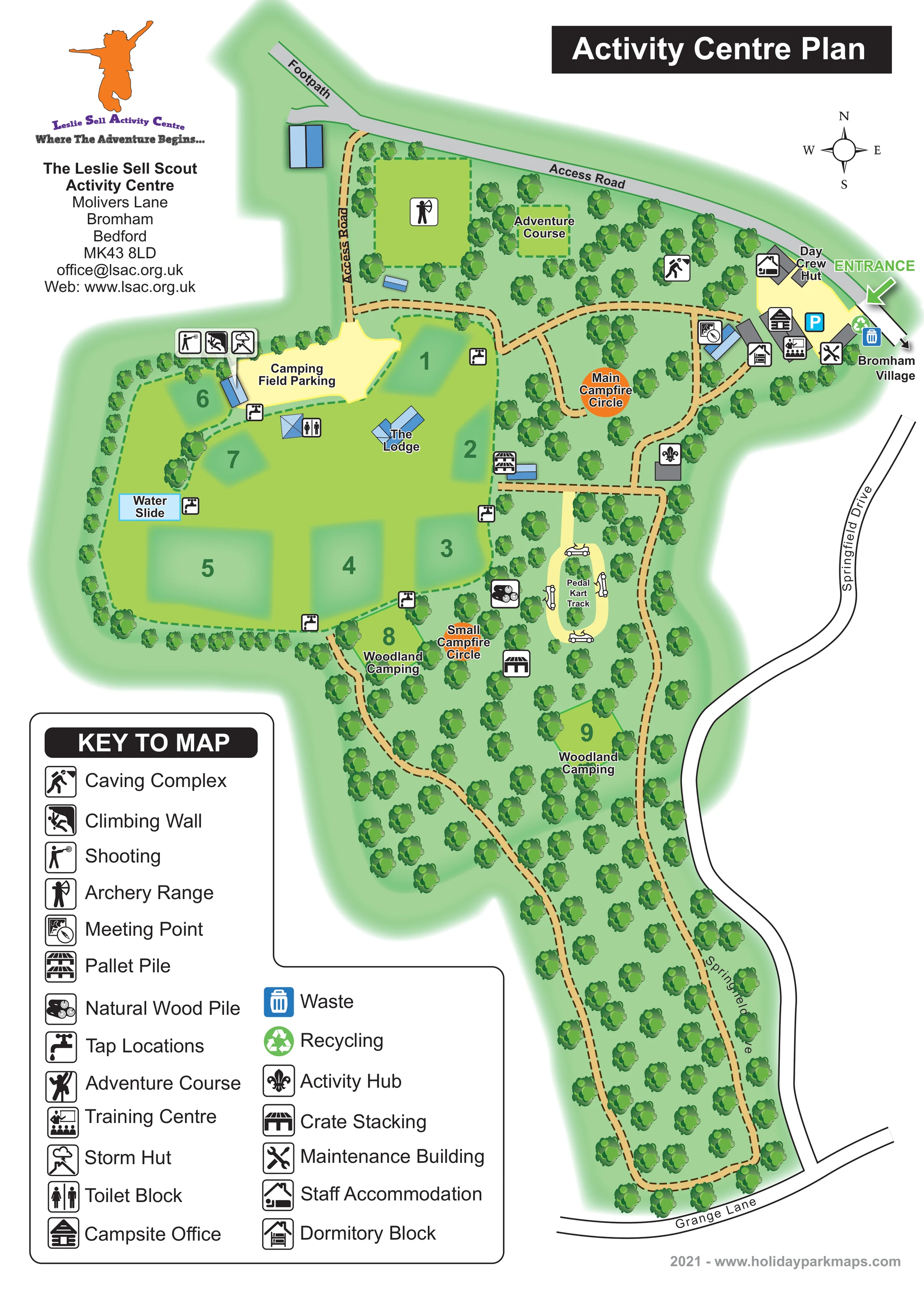
Broad green camping zones surround The Lodge in the western half of the site.
ILLUSTRATED PARK MAP · P622
Molivers Lane, Bromham, Bedford · United Kingdom
 Enlarge the map ↗
A SENSE OF THE PLACE
The Leslie Sell Activity Centre is a Scout and youth activity site at Bromham near Bedford. Camping grounds and indoor accommodation support organised group visits.
The Lodge includes sleeping accommodation, a kitchen and a large indoor activity space, with hiring restrictions for that building set by the centre. Toilets, showers and accessible facilities serve the camping areas, and the map helps groups find their way around the site.
LOOK CLOSER
Broad green camping zones surround The Lodge in the western half of the site.
Areas 8 and 9 are labelled Woodland Camping within the tree-filled southern part of the plan.
Repeated illustrated tree canopies define the perimeter, surround activity locations and fill the long southern extension.
A large green arrow marks the entrance at the upper-right edge, beside a directional reference to Bromham Village.
A grey access road follows the northern boundary; a labelled internal access route descends towards Camping Field Parking.
A footpath continues beyond the north-western end of the boundary access road.
Tan routes with dark dashed centre lines connect the entrance, activity areas and campfire circles, then form a long loop through the southern woodland.
Named neighbouring roads give context along the eastern and southern edges of the site.
Broad green camping zones surround The Lodge in the western half of the site.
Areas 8 and 9 are labelled Woodland Camping within the tree-filled southern part of the plan.
Repeated illustrated tree canopies define the perimeter, surround activity locations and fill the long southern extension.
A large green arrow marks the entrance at the upper-right edge, beside a directional reference to Bromham Village.
A grey access road follows the northern boundary; a labelled internal access route descends towards Camping Field Parking.
A footpath continues beyond the north-western end of the boundary access road.
Tan routes with dark dashed centre lines connect the entrance, activity areas and campfire circles, then form a long loop through the southern woodland.
Named neighbouring roads give context along the eastern and southern edges of the site.
A blue parking symbol marks the entrance-side area, while a larger pale-yellow space beside the open camping ground is labelled Camping Field Parking.
A blue-roofed group accommodation building sits centrally within the open camping ground.
The dormitory pictogram is positioned within the entrance-side group of buildings.
The staff-accommodation pictogram appears beside the northern access road near the entrance.
A directly labelled hut sits beside the entrance approach.
The office pictogram is placed beside the entrance parking area.
A training-centre pictogram marks a building in the entrance-side cluster.
A crossed-tools pictogram identifies the maintenance building near the eastern edge of the entrance cluster.
A map-and-compass pictogram marks the meeting point beside an internal route west of the entrance buildings.
A male-and-female toilet pictogram identifies the block near The Lodge and Camping Field Parking.
Several tap pictograms are distributed around the main camping ground.
Blue waste and green recycling symbols are grouped near the entrance.
An archery pictogram sits within a dashed green activity enclosure in the north-western part of the site.
A labelled, dashed green enclosure marks the adventure course among trees north of the main campfire area.
The caving pictogram is mapped in the northern wooded activity area, west of the entrance.
Climbing and shooting pictograms sit together along the northern edge of the main camping ground.
The storm-hut pictogram is grouped with the climbing and shooting facilities near Camping Field Parking.
A blue-outlined labelled rectangle marks the water slide on the western side of the open camping ground.
Orange markers distinguish the Main Campfire Circle within an internal route loop and the Small Campfire Circle beside woodland camping.
A pale-yellow oval circuit with small kart illustrations surrounds a planted centre east of the main camping ground.
A Scout fleur-de-lis pictogram identifies the activity hub beside the route above the pedal kart track.
The crate-stacking pictogram appears south-west of the pedal kart track in the wooded activity area.
Separate pictograms identify a pallet pile at the eastern edge of the open camping ground and a natural wood pile farther south.
Published centre information describes sleeping accommodation, a kitchen and a large indoor activity space within The Lodge; these internal facilities are not individually drawn.
Published centre information mentions showers and accessible facilities serving the camping areas. The plan itself identifies a toilet block without separately locating these facilities.
READING THE MAP
This illustrated plan of The Leslie Sell Scout Activity Centre in Bromham, near Bedford, brings camping, indoor accommodation and outdoor activities together on one portrait page. Rather than showing rows of individual holiday pitches, it organises the grounds into clearly numbered camping areas, with The Lodge at the heart of the open field and woodland camping extending into the southern part of the site.
The map gives equal attention to arrival and activity planning. A prominent entrance arrow, parking areas and an entrance-side building cluster establish the starting point, while a network of tan routes connects campfire circles, the adventure course, archery, caving and other activity locations. The pedal kart track is drawn as a small illustrated circuit, adding a distinctive landmark among the trees.
Soft green landscape shading conveys the wooded setting, but the practical information stays crisp: large numbers, bold labels and a substantial pictogram key help groups identify facilities without crowding every location with text. It is a useful example of mapping a Scout or youth activity centre where accommodation, shared facilities and outdoor programme spaces all need to be understood together.
The plan follows the centre's irregular outline, with a broad upper section narrowing into a long wooded extension towards Grange Lane. The entrance is positioned at the upper right beside the Bromham Village direction. Nearby, a compact cluster of buildings is identified through symbols for the campsite office, training centre, dormitory block, staff accommodation and maintenance building, with the Day Crew Hut labelled directly. Parking, waste and recycling markers reinforce this arrival area.
To the west, the bright green camping ground contains seven numbered areas arranged around The Lodge. Camping Field Parking occupies a pale-yellow space along its northern edge, and the toilet block and repeated tap symbols identify practical facilities around the field. A water slide is labelled on the western boundary. Shooting, climbing and the storm hut are grouped near the field parking, while archery and the adventure course occupy separate marked areas farther north.
Woodland activities and routes form the eastern and southern parts of the composition. A caving symbol appears north of the Main Campfire Circle, which sits inside a curved route loop. The activity hub lies above the pedal kart track, drawn with a planted centre and small kart illustrations. Pallet and natural wood piles have their own symbols, and crate stacking is marked near the transition into woodland camping. The Small Campfire Circle sits beside the first of the two wooded camping areas.
A long tan route loop continues through the southern trees. Springfield Drive and Grange Lane provide external context, while a northern footpath and compass aid orientation. The large lower-left key explains the map's pictograms. The accompanying enlarged view repeats part of this same artwork to make the key and nearby camping details easier to read; it is not a separate site plan.
KEEP EXPLORING
Chosen for shared landscapes, accommodation or facilities.
 Explore the map ↗
United Kingdom
A wooded Allerton park plan with colour-coded neighbourhoods, touring pitches and a central facilities hub.
 Explore the map ↗
United Kingdom
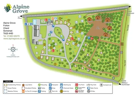
Colour-coded pitches, named log cabins and a woodland trail at Alpine Grove, Somerset.
 Explore the map ↗
United Kingdom
Woodland camping, lodges, lakes and colour-coded bike trails at Avon Tyrrell Outdoor Centre.
Features may come from the sample artwork, its key or published park information. Approximate numbers describe the drawing and may cover only part of a park. They are intended to help you compare map examples. Current facilities and booking information should be checked with the park.
TAKE A CLOSER LOOK
View the illustrated map in detail or choose a file to download. These are sample maps; contact the park for current visitor information.
LET’S MAP YOUR PARK
For a map quotation, find your park and draw a rough boundary around it. The area you select helps us work out the design time and price.
Draw your park for a quote ↗Or talk to our map designers
01751 473136