
River Wye
A broad, curving blue river occupies the western side of the artwork and is explicitly labelled River Wye.
ILLUSTRATED PARK MAP · P335
The Pines Caravan Park, Doldowlod, Llandrindod Wells, Powys Wales · United Kingdom
 Enlarge the map ↗
A SENSE OF THE PLACE
The Pines Holiday Park is an owners-only retreat beside the River Wye at Doldowlod in Mid Wales. Holiday homes are set within a landscape of river valleys and surrounding hills.
Gated access and a focus on private ownership shape the park's quieter atmosphere. Walking and fishing are part of the area's appeal, with the map showing the holiday home layout and routes within the grounds.
LOOK CLOSER
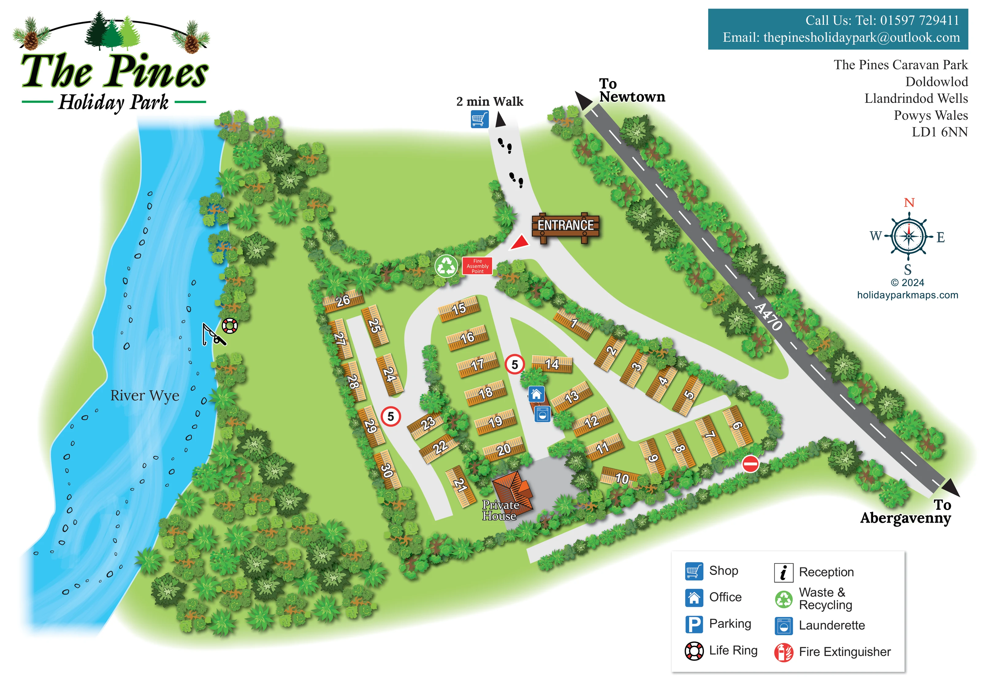
A broad, curving blue river occupies the western side of the artwork and is explicitly labelled River Wye.
Dense tree illustrations line the river, surround the southern grounds and form planted boundaries and dividers between accommodation rows.
An unlabelled expanse of grass lies north of the accommodation, between the river-side planting and entrance approach.
A fishing-rod pictogram marks a location beside the River Wye; it does not state permissions or fishing arrangements.
A life-ring symbol is positioned on the riverbank beside the fishing marker.
The blue office symbol marks a small building within the central accommodation layout.
A washing-machine symbol is placed alongside the office marker at the central service building.
A green recycling symbol marks the entrance-side junction.
A broad, curving blue river occupies the western side of the artwork and is explicitly labelled River Wye.
Dense tree illustrations line the river, surround the southern grounds and form planted boundaries and dividers between accommodation rows.
An unlabelled expanse of grass lies north of the accommodation, between the river-side planting and entrance approach.
A fishing-rod pictogram marks a location beside the River Wye; it does not state permissions or fishing arrangements.
A life-ring symbol is positioned on the riverbank beside the fishing marker.
The blue office symbol marks a small building within the central accommodation layout.
A washing-machine symbol is placed alongside the office marker at the central service building.
A green recycling symbol marks the entrance-side junction.
A red labelled assembly-point panel is shown beside the waste and recycling marker near the entrance.
Footprint symbols, an arrow and a shop pictogram lead beyond the entrance approach, with the artwork annotation '2 min Walk'. The shop is a directional reference rather than a depicted on-site building.
A prominent illustrated timber ENTRANCE sign identifies the northern arrival junction.
The dark-grey A470 runs diagonally along the eastern side, with arrows towards Newtown and Abergavenny.
Pale-grey branching lanes serve the accommodation rows. Red-bordered signs marked 5 and a no-entry symbol appear within the road layout.
A separately labelled, orange-roofed private house stands at the southern end of the central grounds.
Reception appears in the key, but no corresponding position is clearly marked on the plan.
A parking symbol appears in the key without a clearly identifiable mapped location.
Fire extinguisher is included in the key; a corresponding location is not clearly visible in the grounds.
READING THE MAP
This illustrated map of The Pines Holiday Park places a small holiday-home layout within its riverside setting at Doldowlod, near Llandrindod Wells in Powys. The River Wye sweeps down the left side of the page, while the A470 provides a contrasting diagonal landmark on the right. Between them, roughly 30 numbered holiday homes sit along pale-grey lanes, framed by trees and planted boundaries.
The design combines practical orientation with a strong sense of place. A timber-style entrance sign anchors the arrival point, bold numbers identify individual homes, and familiar pictograms locate the office, launderette, recycling point and riverside life ring. A fishing symbol draws attention to the riverbank, while footprints and a short walking annotation point towards a shop beyond the entrance approach.
Pine-themed branding, golden accommodation roofs and layered green foliage give the page its distinctive character. The clear separation between the illustrated grounds, contact information, compass and boxed key makes this a useful sample for smaller ownership parks needing both a readable site plan and an expressive landscape setting.
The single-page plan is organised around three strong visual elements: the River Wye on the west, the A470 on the east and the compact holiday-home layout between them. The river is illustrated in bright blue with flowing translucent strokes and small outlined stones. Varied tree canopies follow its bank and gather into a substantial wooded area towards the lower-left corner. An open green space separates this riverside planting from the northern approach.
A large timber-style ENTRANCE sign marks the arrival junction. Nearby, a green recycling icon and red fire assembly-point panel identify practical landmarks. Beyond this junction, footprints lead upwards to a shop symbol and the annotation '2 min Walk'. The A470 is treated separately in dark grey, with a dashed centre line and directional arrows towards Newtown and Abergavenny.
Within the grounds, pale-grey lanes curve and branch between short rows of golden-roofed holiday homes. Large white numbers with black outlines sit directly on the roofs and rotate with the buildings. Planting divides the rows and softens the perimeter. Office and launderette symbols mark a central service building, while an orange-roofed private house is labelled near the southern end. Red-bordered 5 signs and a no-entry symbol add road-related information. On the riverbank, a fishing-rod pictogram appears beside a life ring.
The lower-right key explains eight symbols, including reception, parking and fire extinguisher entries whose positions are not clearly marked in the grounds. A compass occupies the white space above it. The large logo, teal contact banner and address block complete the page without crowding the illustrated plan.
KEEP EXPLORING
Chosen for shared landscapes, accommodation or facilities.
 Explore the map ↗
United Kingdom
Illustrated lakeside park plan with numbered holiday units, leisure buildings and a looping Woodland Walk.
 Explore the map ↗
United Kingdom
Illustrated caravan park plan with woodland and riverside walks, fishing pools and wildlife panels.
 Explore the map ↗
United Kingdom
A lakeside holiday-park and fishery map with numbered accommodation, fishing positions and clearly grouped visitor services.
Features may come from the sample artwork, its key or published park information. Approximate numbers describe the drawing and may cover only part of a park. They are intended to help you compare map examples. Current facilities and booking information should be checked with the park.
LET’S MAP YOUR PARK
For a map quotation, find your park and draw a rough boundary around it. The area you select helps us work out the design time and price.
Draw your park for a quote ↗Or talk to our map designers
01751 473136