
Railway boundary
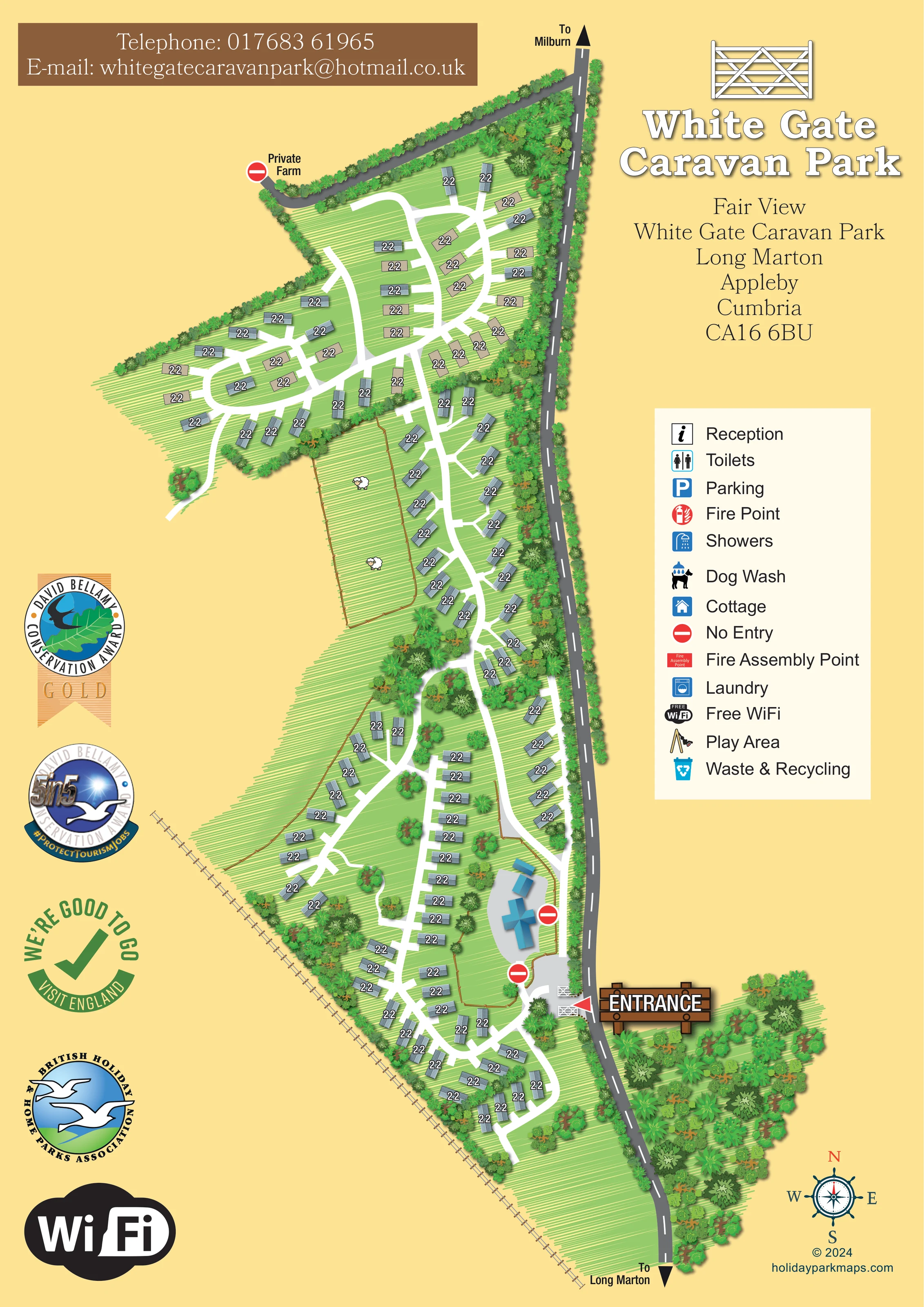
A fine line with repeated sleepers runs diagonally along the south-western edge of the depicted park.
ILLUSTRATED PARK MAP · P363
Fair View, White Gate Caravan Park, Long Marton, Appleby, Cumbria · United Kingdom
 Enlarge the map ↗
A SENSE OF THE PLACE
White Gate Caravan Park is based at Fair View, White Gate Caravan Park, Long Marton, Appleby, Cumbria. The family-owned park occupies over 30 acres of partly wooded pasture in the Eden Valley, near the Settle–Carlisle railway. The operator sells sited static caravans and lodges; pitches have private parking and metered mains gas.
The park describes a wildflower meadow, a boundary walk and planting of over 4,000 trees and hedgerow plants. Free site-wide Wi-Fi and an electric vehicle charging point are advertised.
LOOK CLOSER
A fine line with repeated sleepers runs diagonally along the south-western edge of the depicted park.
Dense tree and shrub symbols enclose much of the park, divide accommodation groups and form a substantial wooded area across the road near the entrance.
A long fenced green enclosure with sheep illustrations occupies a central-western recess in the accommodation layout; further brown fence lines define lower green areas.
White gates, a red pointer and a large timber-style ENTRANCE sign mark arrival from the road on the eastern side, towards the lower end of the plan.
A dark grey road follows the eastern boundary, with directional arrows to Milburn at the top and Long Marton at the bottom.
White branching lanes, loops and short pitch connections link the southern, central and wider northern accommodation areas.
Red no-entry symbols appear beside the entrance-side building compound and at the upper farm approach, which is labelled Private Farm.
Several blue-roofed buildings stand on a grey surfaced compound just north of the entrance. Their individual functions are not labelled on the plan.
White gates, a red pointer and a large timber-style ENTRANCE sign mark arrival from the road on the eastern side, towards the lower end of the plan.
A dark grey road follows the eastern boundary, with directional arrows to Milburn at the top and Long Marton at the bottom.
White branching lanes, loops and short pitch connections link the southern, central and wider northern accommodation areas.
Red no-entry symbols appear beside the entrance-side building compound and at the upper farm approach, which is labelled Private Farm.
A fine line with repeated sleepers runs diagonally along the south-western edge of the depicted park.
Dense tree and shrub symbols enclose much of the park, divide accommodation groups and form a substantial wooded area across the road near the entrance.
A long fenced green enclosure with sheep illustrations occupies a central-western recess in the accommodation layout; further brown fence lines define lower green areas.
Several blue-roofed buildings stand on a grey surfaced compound just north of the entrance. Their individual functions are not labelled on the plan.
Included in the key with an information symbol; a corresponding position is not clearly identified.
Separate toilet and shower symbols appear in the key, without clearly located instances on the plan.
A blue P symbol is listed in the key, but a specific parking location is not clearly marked.
The key includes both a fire-point symbol and a red fire-assembly-point panel; their locations are not clearly established in the illustration.
A dog beneath a shower symbol identifies this amenity in the key only.
A blue house symbol labelled Cottage appears in the key. No particular building is clearly assigned this use.
A washing-machine symbol is listed in the key without a clearly mapped location.
Free WiFi is named in the key, and a large Wi-Fi emblem appears separately in the left-hand page margin.
A swing illustration appears in the key; no play-area position is clearly marked within the site.
A turquoise recycling-bin symbol is included in the key without clearly located instances.
The park information describes a wildflower meadow, boundary walk and extensive tree and hedgerow planting. These are not separately labelled or traced on this artwork.
An electric vehicle charging point is advertised in the park information but is not identified on this map.
READING THE MAP
This illustrated map of White Gate Caravan Park presents a long, tree-lined caravan park at Long Marton, near Appleby in Cumbria’s Eden Valley. Its distinctive shape is central to the design: accommodation follows an eastern roadside, spreads into a wider northern section and curves around a more compact southern area beside the railway. White internal lanes stand out against striped green lawns, making the branching access pattern easy to follow at a glance.
The rural character comes through in dense hedgerows, varied tree crowns and a fenced pasture illustrated with sheep. Arrival receives particular emphasis, with white gates, a red pointer and a large timber-style entrance sign beside the roadside. A separate cream key introduces the park’s facility symbols, while the title, address and contact banner give the page a clear visitor-information structure.
The warm yellow background and prominent conservation emblems make this a useful sample for caravan parks wanting to combine practical site orientation with a strong sense of landscape and identity.
The plan is arranged vertically, with the road towards Milburn and Long Marton forming a continuous dark edge on the right. The main entrance sits towards the southern end, marked by illustrated white gates and an oversized wooden sign. Immediately to its north is a grey surfaced compound containing blue-roofed buildings, with red no-entry markers separating restricted approaches from the surrounding white access lanes.
Accommodation extends through three visually distinct areas. At the bottom, a curved group connects to longer rows beside the railway. The middle section narrows between the roadside and a fenced pasture, before opening into the broad northern area with several linked loops and branching lanes. Caravan-style roof symbols sit at varied angles along these routes, with short white connections making their relationship to the access network explicit. Some northern accommodation rectangles use a tan rather than blue-grey finish.
Landscape is an important organising layer. Tree belts mark boundaries, interrupt long rows and surround small internal islands. Fine diagonal strokes texture the grass, while brown fences and sheep illustrations distinguish pasture from the accommodation lawns. The railway is drawn with repeated sleepers along the south-western edge, and a private farm approach is named at the upper left.
The right-hand key lists reception, toilets, parking, fire points, showers, dog wash, cottage, no entry, fire assembly point, laundry, free Wi-Fi, play area, and waste and recycling. Most service entries are not visibly located within the plan. The portrait page also includes the gate logo, address, contact banner, conservation and tourism emblems, a large Wi-Fi graphic and a compass. The enlarged views show overlapping portions of this same composition, not additional park sections.
KEEP EXPLORING
Chosen for shared landscapes, accommodation or facilities.
 Explore the map ↗
United Kingdom
Woodland-framed Barnsoul map with mixed accommodation, shared facilities and paw-marked walking routes.
 Explore the map ↗
United Kingdom
A wooded, streamside park map with a linked farm, café, touring and cottage area.
 Explore the map ↗
United Kingdom
A colour-zoned coastal park map with touring areas, woodland trails, ponds and a leisure club.
Features may come from the sample artwork, its key or published park information. Approximate numbers describe the drawing and may cover only part of a park. They are intended to help you compare map examples. Current facilities and booking information should be checked with the park.
LET’S MAP YOUR PARK
For a map quotation, find your park and draw a rough boundary around it. The area you select helps us work out the design time and price.
Draw your park for a quote ↗Or talk to our map designers
01751 473136