
Duck ponds
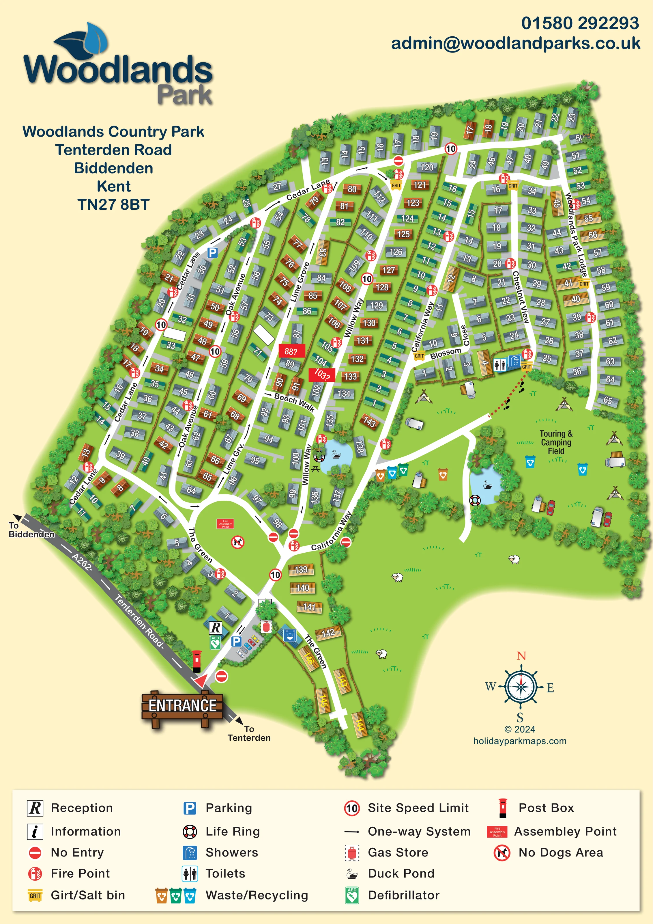
Two pale-blue ponds are illustrated: a smaller pond beside Willow Way and a longer pond at the western edge of the touring and camping field.
ILLUSTRATED PARK MAP · P377
Woodlands Country Park, Tenterden Road, Biddenden, Kent · United Kingdom
 Enlarge the map ↗
A SENSE OF THE PLACE
Woodlands Country Park is based at Tenterden Road, Biddenden, Kent. The site is situated in the Weald of Kent at Biddenden, with countryside and woodland walks nearby. The park primarily markets residential park homes for year-round living and retirement; its FAQ also refers to leisure homes. The contact page explicitly accepts camping enquiries and links to its camping booking listing.
The operator describes the park as pet friendly. The park advertises landscaped gardens, block-paved driveways, furnished homes and 24-hour security.
LOOK CLOSER
Two pale-blue ponds are illustrated: a smaller pond beside Willow Way and a longer pond at the western edge of the touring and camping field.
Dense illustrated trees wrap the perimeter, screen the roadside homes and separate the ponds, home rows and camping field.
A central entrance-side green contrasts with the dense home rows. Broader grassland to the south-east is decorated with sheep illustrations.
Reception is marked beside the entrance approach, close to parking and the defibrillator.
Blue parking symbols identify an entrance-side car park and another parking location beside Cedar Lane.
Paired toilet and shower symbols sit at the southern end of Chestnut View, immediately above the touring and camping field.
A blue washing-machine pictogram marks a building opposite the entrance-side reception area. It is not explained in the legend.
Grouped coloured bins are shown beside the camping-field approach, with additional bins within the field.
Reception is marked beside the entrance approach, close to parking and the defibrillator.
Blue parking symbols identify an entrance-side car park and another parking location beside Cedar Lane.
Paired toilet and shower symbols sit at the southern end of Chestnut View, immediately above the touring and camping field.
A blue washing-machine pictogram marks a building opposite the entrance-side reception area. It is not explained in the legend.
Grouped coloured bins are shown beside the camping-field approach, with additional bins within the field.
Yellow grit-bin symbols occur at several road junctions and beside the toilet and shower location.
Repeated red fire-point symbols are distributed throughout the home areas and near the camping facilities.
A red labelled assembly point is placed on the broad lawn enclosed by The Green.
A green AED symbol is positioned beside reception near the entrance.
A gas-cylinder symbol in a dashed box marks the entrance-side service area opposite reception.
A red post-box illustration stands beside the entrance junction with Tenterden Road.
Two pale-blue ponds are illustrated: a smaller pond beside Willow Way and a longer pond at the western edge of the touring and camping field.
Life-ring symbols are shown beside both ponds.
A picnic-table illustration sits beside the smaller pond near Willow Way.
Dense illustrated trees wrap the perimeter, screen the roadside homes and separate the ponds, home rows and camping field.
A central entrance-side green contrasts with the dense home rows. Broader grassland to the south-east is decorated with sheep illustrations.
The entrance connects to the A262, labelled Tenterden Road, with external directions towards Biddenden and Tenterden.
Road names include Cedar Lane, Oak Avenue, Lime Grove, Willow Way, California Way, Chestnut View, Blossom Close, Beech Walk, The Green and Woodlands Park Lodge.
Black directional arrows, red no-entry symbols and circular '10' speed-limit symbols explain the mapped vehicle circulation.
A short red dashed route with black footprints links the camping field to the toilet and shower location.
A crossed-out dog symbol marks the lawn inside The Green; this is a local map designation, not a park-wide pet policy.
An information symbol appears in the legend, but a corresponding location is not clearly identifiable on the plan.
READING THE MAP
This illustrated map of Woodlands Country Park brings together a substantial park-home neighbourhood and a separate touring and camping field in Biddenden, Kent. Set against a warm cream background, the plan uses bright lawns, densely planted boundaries and two blue duck ponds to convey the country-park setting while keeping the internal road network prominent.
The entrance from Tenterden Road is marked by a timber-style sign, with reception, parking and service symbols clustered just inside. Beyond it, named lanes thread between rows of numbered homes, passing The Green before reaching the eastern home areas and open camping space. White roads and bold plot numbers provide the practical framework; shaded roofs, trees, caravans and small countryside illustrations give the artwork its pictorial character.
A wide legend beneath the plan explains facilities, traffic markings and safety symbols. This sample is particularly relevant to residential and mixed-use parks that need one map to explain a complex home layout, visitor arrival and a less formally arranged touring area without losing the landscape that gives the site its identity.
The portrait artwork presents one continuous site plan, with the A262 Tenterden Road running diagonally along its south-western edge. Directions towards Biddenden and Tenterden frame the main entrance. Reception, parking, a post box, a defibrillator and a gas-store symbol establish the arrival area, while a washing-machine pictogram marks a nearby building.
Inside the park, The Green forms a broad lawn enclosed by roads, carrying an assembly-point label and a local no-dogs symbol. Cedar Lane follows much of the western boundary; Oak Avenue, Lime Grove and Willow Way organise the closely spaced interior home rows. California Way connects towards the eastern section, where Chestnut View, Blossom Close and Woodlands Park Lodge provide further named routes. A narrow home-lined branch extends south from the main network. Numbered roof illustrations, grey driveway strips and selected fence lines make the individual plots legible without requiring a separate accommodation key.
The eastern Touring & Camping Field is shown as open grass containing illustrative tents, caravans and cars. A red dashed connection with footprints leads towards toilet and shower symbols at the end of Chestnut View. Waste and recycling bins appear around the field and its approach. Two duck ponds, each accompanied by a life-ring symbol, sit among planted screens; the smaller pond also has a picnic-table illustration.
Repeated fire points and grit bins are integrated into the road network. One-way arrows, no-entry symbols and circular speed-limit signs add a traffic layer. The page finishes with a four-column legend, a decorative compass and designer credit. Layered tree illustrations, roof shadows and sheep in the adjoining grassland soften the dense plan while retaining clear distinctions between homes, roads, facilities and open land.
KEEP EXPLORING
Chosen for shared landscapes, accommodation or facilities.
 Explore the map ↗
United Kingdom
Woodland-framed Barnsoul map with mixed accommodation, shared facilities and paw-marked walking routes.
 Explore the map ↗
United Kingdom
A colour-zoned coastal park map with touring areas, woodland trails, ponds and a leisure club.
 Explore the map ↗
United Kingdom
Woodland holiday-park map with named accommodation areas, touring loops and illustrated recreation facilities.
Features may come from the sample artwork, its key or published park information. Approximate numbers describe the drawing and may cover only part of a park. They are intended to help you compare map examples. Current facilities and booking information should be checked with the park.
LET’S MAP YOUR PARK
For a map quotation, find your park and draw a rough boundary around it. The area you select helps us work out the design time and price.
Draw your park for a quote ↗Or talk to our map designers
01751 473136