
Fishing lakes and pond
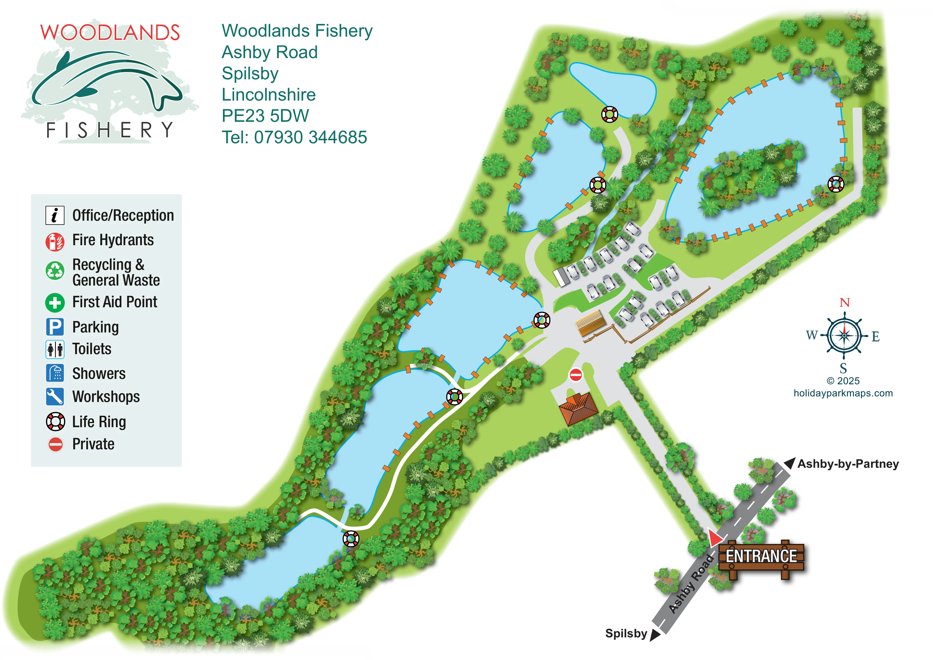
Six separate blue water bodies form the main structure of the plan, extending from the wooded south-western end to the large north-eastern lake. Individual waters are not named.
ILLUSTRATED PARK MAP · P378
Woodlands Fishery, Ashby Road, Spilsby, Lincolnshire · United Kingdom
 Enlarge the map ↗
A SENSE OF THE PLACE
Woodlands Fishery Spilsby is based at Ashby Road, Spilsby, Lincolnshire. Five fishing lakes and a stock pond occupy a 12-acre countryside site on the edge of Spilsby in the Lincolnshire Wolds. The park offers adults-only touring pitches for caravans and motorhomes, with electric hook-up, water and grey-waste connections. Lincoln Lodge and Scranton Lodge are for guests aged 16 or over and each has a private wood-fired hot tub; Lincoln accepts dogs while Scranton is pet free.
Heated amenities include showers and an accessible bathroom; there are washing-up facilities, an Elsan point and a tackle-and-essentials shop.
LOOK CLOSER
Six separate blue water bodies form the main structure of the plan, extending from the wooded south-western end to the large north-eastern lake. Individual waters are not named.
An elongated, densely planted island sits within the largest lake.
Dense woodland encloses the south-western waters; tree belts, hedges and smaller shrubs frame the other lakes, entrance drive and touring pitches.
A slender pale-blue watercourse runs through the planted strip beside the northern touring area.
Small orange rectangular platforms or fishing positions punctuate several lake margins, particularly the large lake and the central waters.
Pale routes branch from the central accommodation area, follow lake margins and continue towards the wooded south-western end.
A prominent timber-style ENTRANCE sign and red pointer identify the access from Ashby Road, followed by a long hedge-lined drive.
Opposing arrows on the external road indicate Spilsby and Ashby-by-Partney.
Six separate blue water bodies form the main structure of the plan, extending from the wooded south-western end to the large north-eastern lake. Individual waters are not named.
Small orange rectangular platforms or fishing positions punctuate several lake margins, particularly the large lake and the central waters.
An elongated, densely planted island sits within the largest lake.
Dense woodland encloses the south-western waters; tree belts, hedges and smaller shrubs frame the other lakes, entrance drive and touring pitches.
A slender pale-blue watercourse runs through the planted strip beside the northern touring area.
Pale routes branch from the central accommodation area, follow lake margins and continue towards the wooded south-western end.
A prominent timber-style ENTRANCE sign and red pointer identify the access from Ashby Road, followed by a long hedge-lined drive.
Opposing arrows on the external road indicate Spilsby and Ashby-by-Partney.
Large red, white and black life-ring symbols are positioned beside the waters and explained in the legend.
A red no-entry-style symbol marks a private branch towards the orange-roofed building near the arrival area.
Listed with an information symbol in the legend; no corresponding position is clearly marked on the plan.
A red fire-equipment symbol appears in the legend, without clearly identifiable placements in the illustrated grounds.
A green recycling symbol and combined waste label are included in the key; a location is not established.
Named in the key with a green cross, but not clearly located on the plan.
A blue P symbol is provided in the legend; the artwork does not clearly identify a separate marked parking area.
Separate toilet and shower symbols appear in the legend, without clear building assignments.
Listed with a blue spanner symbol in the legend; the unlabelled buildings cannot confidently be assigned this function.
READING THE MAP
This illustrated map of Woodlands Fishery in Spilsby, Lincolnshire, puts the fishing landscape at the centre of the visitor experience. A chain of blue waters stretches across the page, enclosed by woodland, hedges and planted banks. The largest lake contains a wooded island, while orange bankside fishing positions give several of the waters a distinctive rhythm. A compact touring area sits between the lakes, represented by white leisure vehicles arranged around short internal lanes.
Arrival is particularly prominent. Ashby Road, directions towards Spilsby and Ashby-by-Partney, and a large timber-style entrance sign lead the eye into a long, hedge-lined drive. From there, the plan opens into the touring hub and the routes around the water. The fishery logo, address block and spacious symbol key balance the irregular shape of the grounds. This sample is useful for fisheries and small touring parks that need to explain a landscape-led site, where access, waterside routes and recognisable natural landmarks matter more than a numbered accommodation grid.
The plan follows the fishery’s elongated shape, from the densely wooded lower-left end to the broad lake at upper right. Six separate water bodies are illustrated in pale blue with bright cyan outlines. Several have orange rectangular fishing positions along their banks, and the largest includes a long wooded island. Varied tree crowns and shrubs distinguish dense woodland from more open grass and planted boundaries. A narrow blue watercourse is also visible beside the northern part of the touring cluster.
Access begins at the lower-right edge, where a red pointer and timber-style ENTRANCE sign mark the junction with Ashby Road. Destination arrows indicate Spilsby in one direction and Ashby-by-Partney in the other. The pale-grey entrance drive passes between hedges before reaching a central junction. Short branching lanes serve roughly 20 touring pitches, illustrated with white leisure vehicles and separated by small planting groups. A timber fence borders part of this area, and several individually drawn but unlabelled buildings provide visual landmarks. One branch towards an orange-roofed building carries the private symbol.
Pale lakeside routes extend from the central hub towards both ends of the site. Bold life-ring symbols punctuate the waterside network. The left-hand legend also lists office/reception, fire hydrants, recycling and general waste, first aid, parking, toilets, showers and workshops, although those entries are not clearly positioned on the grounds. A large fishery logo and teal contact block sit above the key, while a nautical compass fills open space on the right. Together, these elements keep the long, irregular site readable without relying on pitch numbers or named lake sections.
KEEP EXPLORING
Chosen for shared landscapes, accommodation or facilities.
 Explore the map ↗
United Kingdom
Woodland park map with mixed pitches, bell tents, lodges and a fishing lake.
 Explore the map ↗
United Kingdom
Illustrated lakeside park plan with numbered holiday units, leisure buildings and a looping Woodland Walk.
 Explore the map ↗
United Kingdom
A lakeside holiday-park and fishery map with numbered accommodation, fishing positions and clearly grouped visitor services.
Features may come from the sample artwork, its key or published park information. Approximate numbers describe the drawing and may cover only part of a park. They are intended to help you compare map examples. Current facilities and booking information should be checked with the park.
LET’S MAP YOUR PARK
For a map quotation, find your park and draw a rough boundary around it. The area you select helps us work out the design time and price.
Draw your park for a quote ↗Or talk to our map designers
01751 473136