
Pond
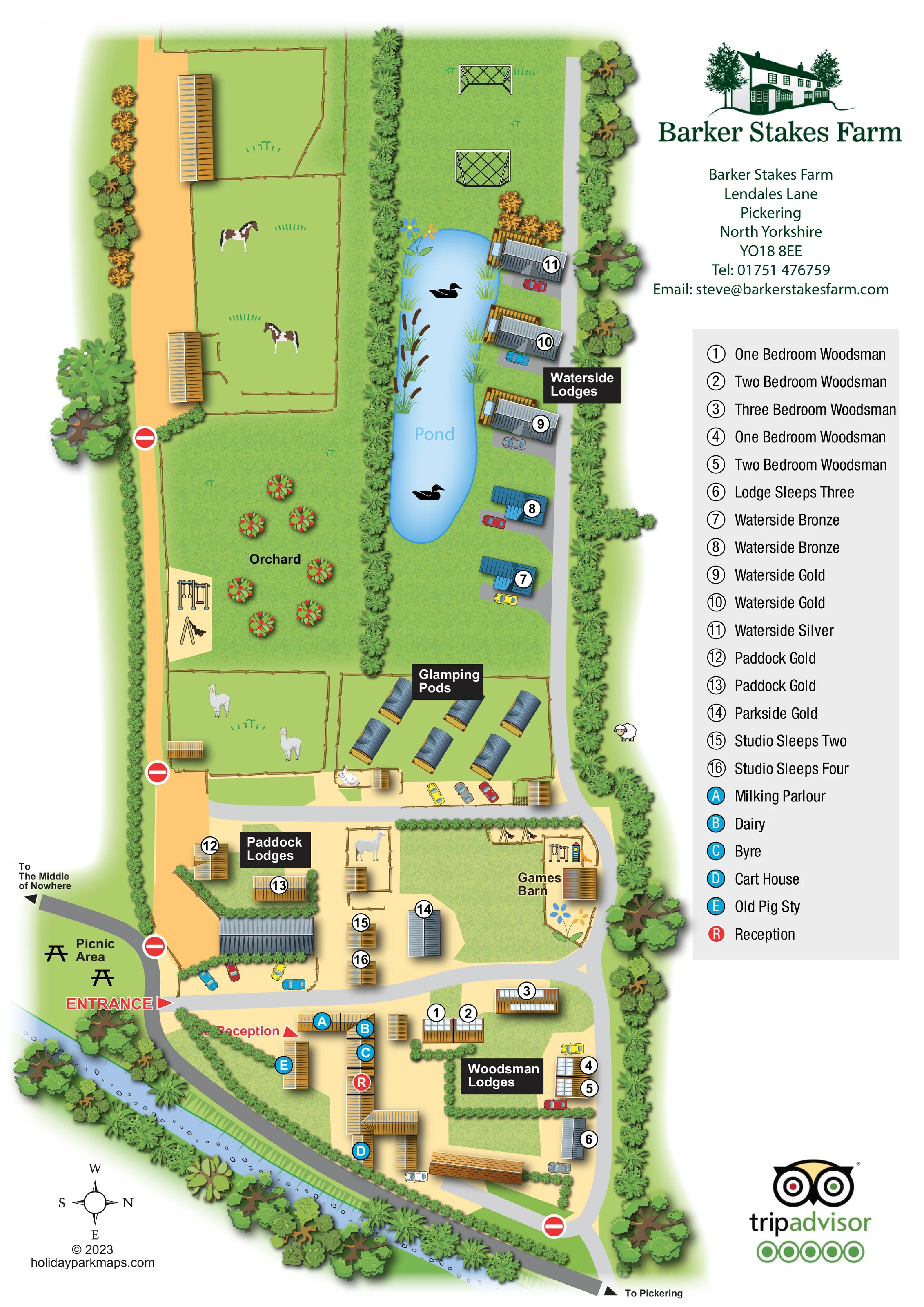
An elongated blue pond forms the centrepiece of the upper accommodation area, with Waterside lodges along one bank and illustrated ducks and marginal plants.
ILLUSTRATED PARK MAP · P016
Barker Stakes Farm, Lendales Lane, Pickering, North Yorkshire · United Kingdom
 Enlarge the map ↗
A SENSE OF THE PLACE
Barker Stakes Farm offers self-catering accommodation beside Pickering Beck near Pickering, on the edge of the North York Moors. Timber lodges sit within a working-farm setting with grounds to explore.
The farm's visitor information describes fishing, outdoor games and a children's play area. It offers a countryside base for families and couples, with the market town and moorland landscapes adding to the appeal of the location.
LOOK CLOSER
An elongated blue pond forms the centrepiece of the upper accommodation area, with Waterside lodges along one bank and illustrated ducks and marginal plants.
A labelled fruit-tree area sits between the horse paddocks and the lower animal enclosures, separated from the pond by a substantial hedge.
Fenced areas illustrate horses, alpaca-like animals, a goat and a rabbit, with small shelters. These communicate the farm setting rather than a stated animal-interaction service.
A blue, tree-lined watercourse runs diagonally beside the lower access lane. The supplied park context identifies the setting as beside Pickering Beck.
Dense boundary planting, internal hedges and timber fences divide the accommodation, orchard, animal enclosures and recreation areas.
Located within the lower farm-building group, identified by a red R marker and a separate arrival-direction arrow.
A labelled building beside the central recreation lawn and play equipment.
Swings and climbing equipment appear beside the orchard; another group of swings, climbing equipment and a slide is illustrated near the Games Barn.
Located within the lower farm-building group, identified by a red R marker and a separate arrival-direction arrow.
A labelled building beside the central recreation lawn and play equipment.
Swings and climbing equipment appear beside the orchard; another group of swings, climbing equipment and a slide is illustrated near the Games Barn.
Two goals are illustrated on the grass beyond the upper end of the pond.
A labelled grassy area with picnic-table symbols lies beside the entrance and external lane.
An elongated blue pond forms the centrepiece of the upper accommodation area, with Waterside lodges along one bank and illustrated ducks and marginal plants.
A labelled fruit-tree area sits between the horse paddocks and the lower animal enclosures, separated from the pond by a substantial hedge.
Fenced areas illustrate horses, alpaca-like animals, a goat and a rabbit, with small shelters. These communicate the farm setting rather than a stated animal-interaction service.
A blue, tree-lined watercourse runs diagonally beside the lower access lane. The supplied park context identifies the setting as beside Pickering Beck.
Dense boundary planting, internal hedges and timber fences divide the accommodation, orchard, animal enclosures and recreation areas.
Blue letter markers locate the Milking Parlour, Dairy, Byre, Cart House and Old Pig Sty near reception. Their names are explicit, but their present functions are not stated.
A prominent red entrance arrow marks the turn from the external lane into the site, followed by a red direction to reception.
Grey lanes connect the lower accommodation, central yard, pods and Waterside lodges. Red no-entry symbols appear at several junctions and lane edges.
Small coloured cars indicate parking beside individual lodges, the pod enclosure and the central farmyard.
The external lane is annotated 'To Pickering' at the lower right and 'To The Middle of Nowhere' at the left.
Fishing is mentioned in the supplied visitor information, but the map does not label a fishing location or designate the illustrated pond for that use.
READING THE MAP
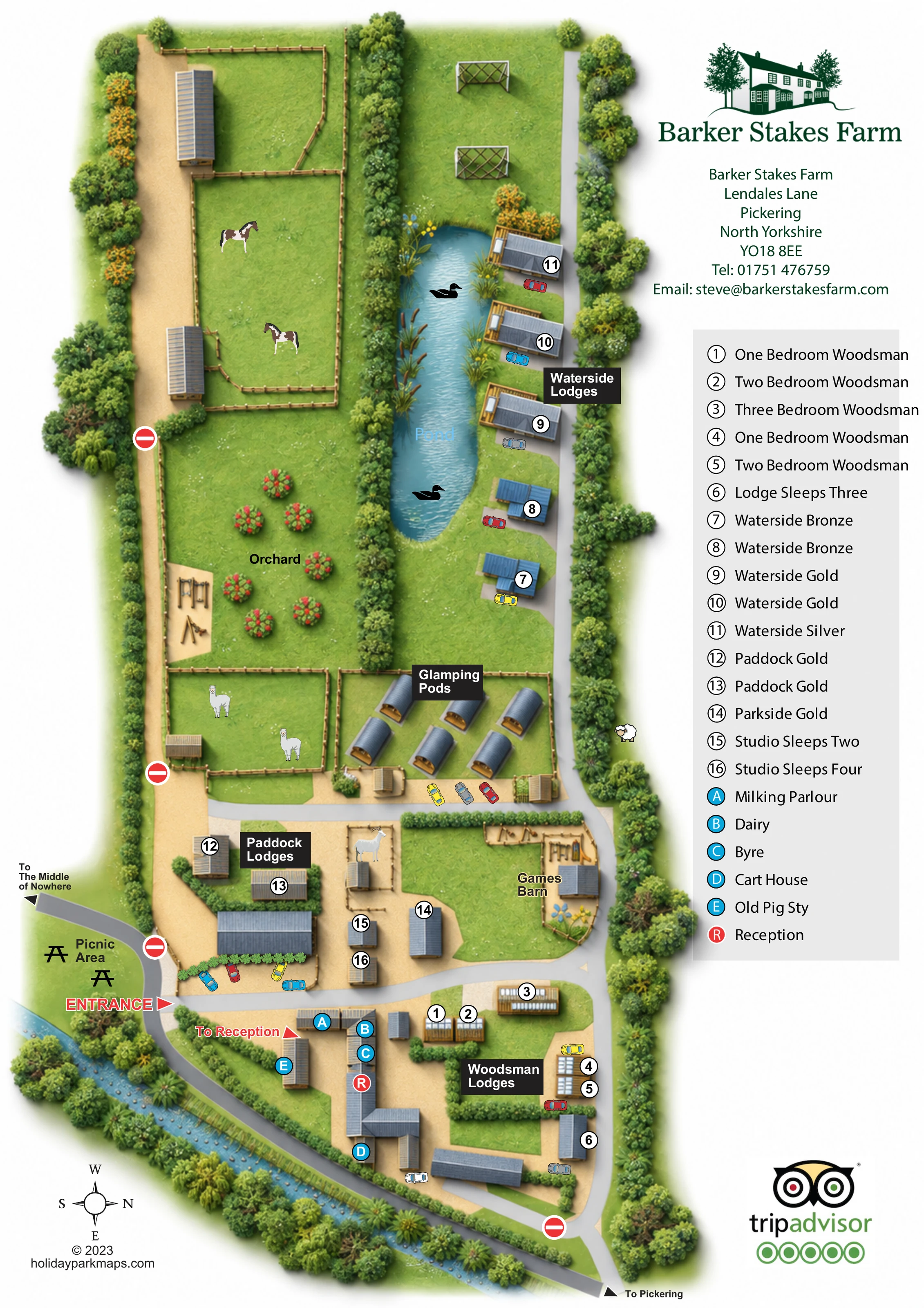
This illustrated map of Barker Stakes Farm brings a small countryside holiday site near Pickering into a single, characterful plan. Lodges, studios and glamping pods share the grounds with an orchard, animal paddocks, play spaces and a long pond, while a tree-lined beck follows the lower edge of the artwork. The farm setting is central to the design rather than a decorative backdrop: fences, shelters and illustrated animals help visitors understand how the different parts of the site fit together.
The portrait layout gives the elongated grounds room to unfold. Woodsman lodges sit near reception and the main farm buildings, Paddock accommodation occupies the central yard, and Waterside lodges line one bank of the pond. A compact pod enclosure creates another clearly recognisable destination. Bold area labels offer a quick overview, while numbered accommodation markers connect to a detailed key in the right-hand column.
For a designer's gallery, this is a useful example of mapping a mixed self-catering and glamping site where landscape, farm character and arrival information need equal attention.
The plan begins with a clearly marked entrance beside the picnic area and external lane. A red arrow directs visitors towards reception within the lower farm-building group, where blue letter markers identify the Milking Parlour, Dairy, Byre, Cart House and Old Pig Sty. Nearby, Woodsman lodges occupy small hedged plots, with individual buildings, roof forms and parking positions illustrated rather than reduced to identical rectangles.
Grey internal lanes connect this lower area to the central yard and continue along the right-hand side of the grounds. Paddock lodges, a Parkside unit and two studios sit around this middle section. The Games Barn borders an open lawn, with swings, climbing equipment and a slide drawn nearby. Above it, curved-roof glamping pods form a compact fenced group beside animal enclosures. Further play equipment appears at the edge of the orchard, giving visitors two readily distinguishable recreation locations.
The upper part of the map is organised around an elongated pond. Waterside lodges follow one bank, while a thick hedge separates the water from the orchard and horse paddocks. Ducks, reeds and flowering plants give the pond a softer illustrated treatment; football goals appear on grass beyond its upper end. Trees and hedges frame the site, and the beck creates a diagonal blue boundary below the reception area.
The right-hand column holds the farmhouse logo, contact information and accommodation key. White numbered circles link units to their descriptions, while black destination panels identify the main accommodation groups. A compass, off-site arrows and red no-entry symbols complete the wayfinding layer. The artwork is a single portrait site plan; the enlarged views reveal details of that same composition.
 Enlarge this map ↗
KEEP EXPLORING
Chosen for shared landscapes, accommodation or facilities.
 Explore the map ↗
United Kingdom
Portrait park map with mixed touring pitches, seasonal rows, ponds and an extensive dog walk.
 Explore the map ↗
United Kingdom
A woodland estate park map combining caravan loops, touring pitches, riverside paths and Bruce’s Cave landmarks.
 Explore the map ↗
United Kingdom
Woodland-framed Barnsoul map with mixed accommodation, shared facilities and paw-marked walking routes.
Features may come from the sample artwork, its key or published park information. Approximate numbers describe the drawing and may cover only part of a park. They are intended to help you compare map examples. Current facilities and booking information should be checked with the park.
LET’S MAP YOUR PARK
For a map quotation, find your park and draw a rough boundary around it. The area you select helps us work out the design time and price.
Draw your park for a quote ↗Or talk to our map designers
01751 473136