
Lake Josh, John's Pond and Charle's Pond
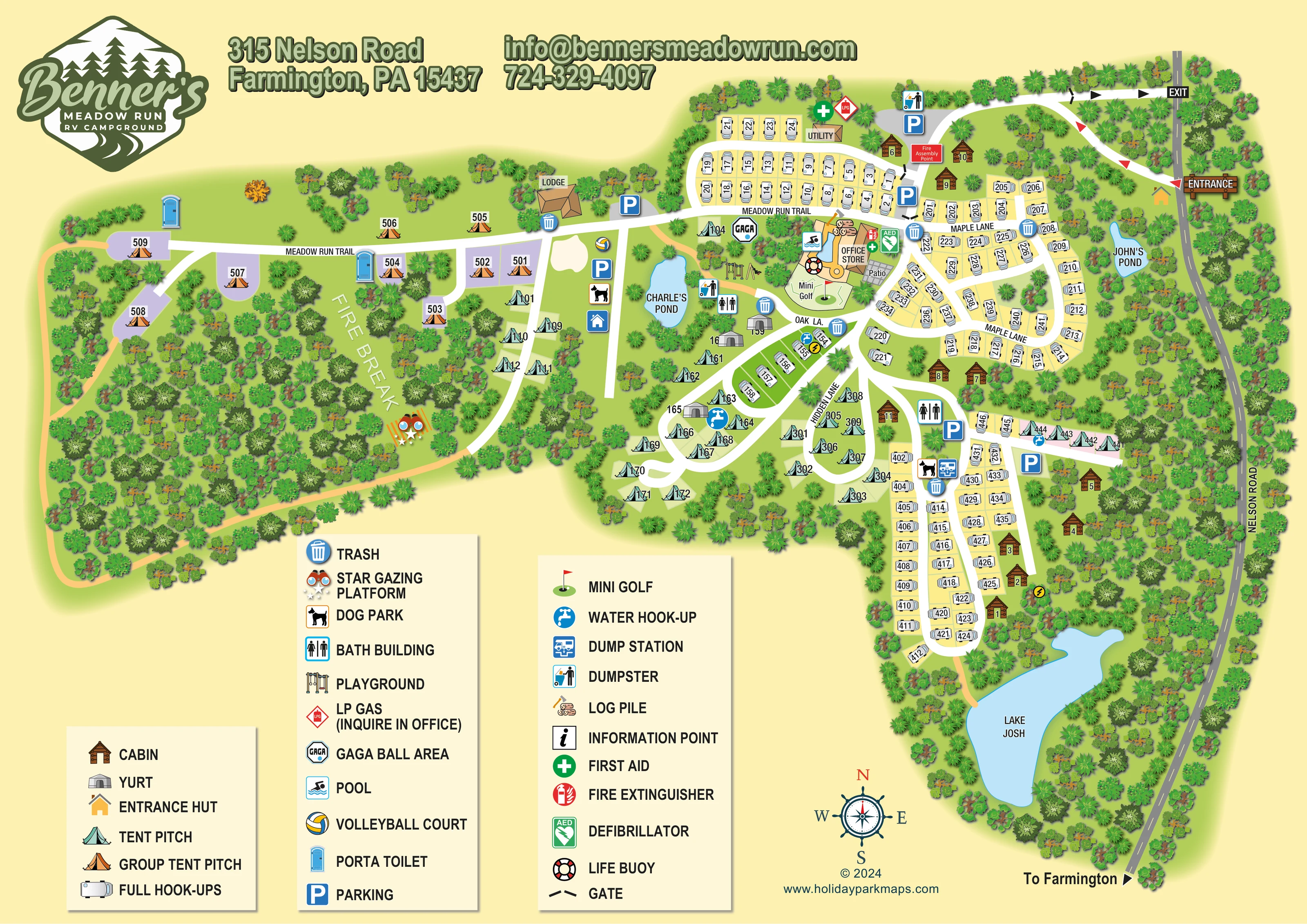
Three labelled blue water features provide strong landmarks: Lake Josh at the southern end, John's Pond near Nelson Road and Charle's Pond west of the central facilities.
ILLUSTRATED PARK MAP · P023
315 Nelson Road, Farmington, Pennsylvania · United States
 Enlarge the map ↗
A SENSE OF THE PLACE
Benner's Meadow Run RV Campground is a base for exploring Ohiopyle and Pennsylvania's Laurel Highlands. It offers camping, RV stays and cabins, with a long history of welcoming families to the area.
Outdoor excursions include hiking, cycling, fishing and rafting on the Youghiogheny River. The campground also advertises seasonal events and family activities, giving visitors options for time on site as well as days out.
LOOK CLOSER
Three labelled blue water features provide strong landmarks: Lake Josh at the southern end, John's Pond near Nelson Road and Charle's Pond west of the central facilities.
Dense illustrated woodland wraps around the accommodation sections. A broad western clearing is labelled FIRE BREAK and includes the star gazing platform.
A labelled building forms the centre of the principal visitor-facility cluster, beside the pool and patio.
An illustrated blue pool with a tan surround sits beside the office and store.
A grey paved patio is labelled immediately beside the office and store.
A small outlined course and red-flag symbol occupy the space south of the pool.
Illustrated play equipment is positioned west of the pool, near Charle's Pond.
An octagonal GAGA symbol marks an activity area north of the playground.
A labelled building forms the centre of the principal visitor-facility cluster, beside the pool and patio.
An illustrated blue pool with a tan surround sits beside the office and store.
A grey paved patio is labelled immediately beside the office and store.
A small outlined course and red-flag symbol occupy the space south of the pool.
Illustrated play equipment is positioned west of the pool, near Charle's Pond.
An octagonal GAGA symbol marks an activity area north of the playground.
A volleyball symbol marks the recreation area west of Charle's Pond, near the lodge and parking.
A distinctive binoculars-and-stars symbol marks a platform in the western fire-break clearing.
Dog symbols mark areas west of Charle's Pond and beside the southern camping and RV sections.
Bath-building symbols appear around the central and southern sections; portable toilets serve the western group camping area.
Blue tap symbols identify water points among the central pitches and along the eastern tent row.
A blue RV-service symbol marks a dump station beside the southern dog park and waste point.
Repeated bin symbols and separate dumpster pictograms are distributed around accommodation and service areas.
An LP gas symbol appears beside the northern utility building; the legend directs enquiries to the office.
A logs-and-axe illustration is placed just north of the pool and office.
A larger roofed building labelled LODGE stands along Meadow Run Trail between the western camping area and the main pitch groups.
A labelled utility building is shown beside the northern RV loop.
First-aid symbols appear at the utility building and office; fire-extinguisher and AED symbols are grouped beside the office.
A life-buoy symbol is placed at the pool.
A red labelled assembly-point marker is shown near the northern parking and entrance approach.
An information-point symbol is included in the legend, but a corresponding position is not clearly identifiable on the plan.
Blue P symbols identify parking near the entrance, lodge, western recreation area and southern accommodation.
Separate entrance and exit connections meet Nelson Road at the northeast. An entrance hut, gate marks and directional arrows clarify the approach.
Meadow Run Trail, Maple Lane, Oak La. and Hidden Lane identify the main internal routes; Nelson Road runs along the eastern edge with a direction to Farmington.
Ochre paths run around the western wooded section, connect central recreation areas and extend from the southern RV loop towards Lake Josh.
Three labelled blue water features provide strong landmarks: Lake Josh at the southern end, John's Pond near Nelson Road and Charle's Pond west of the central facilities.
Dense illustrated woodland wraps around the accommodation sections. A broad western clearing is labelled FIRE BREAK and includes the star gazing platform.
READING THE MAP
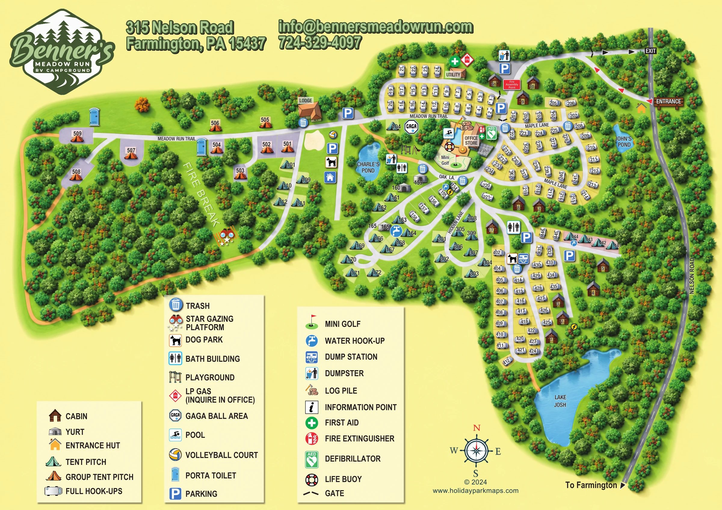
This illustrated map of Benner's Meadow Run RV Campground in Farmington, Pennsylvania brings together a wooded camping layout, varied accommodation and a busy family recreation hub. Full-hook-up RV pitches occupy several looping road groups, while individual tents, group camping, cabins and yurts are given distinct illustrations that make the different areas easy to recognise.
The map has a particularly memorable landscape structure. Lake Josh anchors the southern end, John's Pond sits near the eastern boundary and Charle's Pond provides a landmark beside the central facilities. To the west, group tent pitches extend along Meadow Run Trail into a tree-lined section with a labelled fire break and star gazing platform.
Rather than treating the campground as a grid of numbered pitches, the artwork shows how its roads, woodland, water features and shared spaces fit together. A large lower-page legend explains the accommodation and facility symbols, while the entrance and exit arrows establish the approach from Nelson Road. The result is a useful sample for campgrounds needing to explain several accommodation types within an informal, landscape-led layout.
The single landscape-format plan places Nelson Road along the eastern edge, with separate entrance and exit connections at the northeast. An entrance hut and contrasting directional arrows establish the arrival arrangement before the internal roads branch towards the accommodation. Meadow Run Trail crosses the upper part of the campground and continues west past the lodge into the group camping section. Maple Lane, Oak La. and Hidden Lane organise the central and eastern loops.
White RV illustrations sit on mainly pale-yellow plots, forming compact rows around the northern loop, the Maple Lane area and the longer southern section. Teal tent symbols occupy smaller, more open clusters around the centre and southwest, with a short additional row towards the east. Grey yurts are interspersed among the central camping pitches. Brown cabin drawings sit near the entrance and along wooded eastern margins, while orange group tents distinguish the western camping area.
The principal facility hub combines the office and store, pool, patio and mini golf. Nearby symbols identify the playground, gaga ball area and bath building. Volleyball and a dog park are marked west of Charle's Pond; another dog park and the RV dump station sit farther south. Water points, waste facilities, parking and toilets recur across the plan. Safety symbols at the office include first aid, a fire extinguisher and a defibrillator, with a life buoy beside the pool.
Dense tree illustrations frame three named water features and the western fire-break clearing. Ochre paths provide a visual contrast to the white roads, including a route towards Lake Josh. Three large legend panels, a compass and prominent campground branding complete the page.
 Enlarge this map ↗
KEEP EXPLORING
Chosen for shared landscapes, accommodation or facilities.
 Explore the map ↗
United Kingdom
Colour-coded accommodation, woodland ponds and a Tarka Trail footpath on Smytham’s illustrated park map.
 Explore the map ↗
United Kingdom
Woodland park map with mixed pitches, bell tents, lodges and a fishing lake.
 Explore the map ↗
United Kingdom
A colour-zoned coastal park map with touring areas, woodland trails, ponds and a leisure club.
Features may come from the sample artwork, its key or published park information. Approximate numbers describe the drawing and may cover only part of a park. They are intended to help you compare map examples. Current facilities and booking information should be checked with the park.
LET’S MAP YOUR PARK
For a map quotation, find your park and draw a rough boundary around it. The area you select helps us work out the design time and price.
Draw your park for a quote ↗Or talk to our map designers
01751 473136