
Wooded edges and planting belts
Dense illustrated tree belts enclose much of the eastern edge, follow the watercourse and separate parts of the accommodation.
ILLUSTRATED PARK MAP · P026
Black Hall Lodges, Llanfair Waterdine, Knighton, Powys · United Kingdom
 Enlarge the map ↗
A SENSE OF THE PLACE
Black Hall Lodges occupies a countryside setting near Knighton on the Welsh border, with access to walking country around Offa's Dyke. Self-catering lodges form the focus of a stay.
The shared leisure building includes an indoor pool, sauna, steam room, games room and a small gym. Play areas and walks provide outdoor options, making the site suitable for combining a lodge break with time in the surrounding hills and valleys.
LOOK CLOSER
Dense illustrated tree belts enclose much of the eastern edge, follow the watercourse and separate parts of the accommodation.
A bright blue watercourse runs through the site, with a broader reed-fringed water area near the middle lodge group.
Broad green spaces lie between the lodge groups, watercourse and woodland edge, decorated with sparse grass and flower motifs.
Orange lines with repeated posts follow parts of the approach, play-area boundary and connecting road.
A red R identifies reception at a green-roofed building near the lower accommodation group and central road junction.
Included in the facility callout pointing to the blue-roofed leisure building.
The swimming symbol in the leisure-building callout is identified as an indoor swimming pool by the legend.
Shown among the facilities grouped at the blue-roofed leisure building.
A red R identifies reception at a green-roofed building near the lower accommodation group and central road junction.
Included in the facility callout pointing to the blue-roofed leisure building.
The swimming symbol in the leisure-building callout is identified as an indoor swimming pool by the legend.
Shown among the facilities grouped at the blue-roofed leisure building.
Both symbols appear in the shared leisure-building callout.
Two distinct games symbols are grouped in the leisure-building callout.
A basketball symbol appears in the leisure-building callout; a separate outdoor court is not drawn.
Identified by a television pictogram within the leisure-building facility cluster.
An exercise-bike pictogram locates the gym within the shared leisure-building cluster.
Blue charging symbols appear near reception and within the upper lodge group.
A slide tower and swings are illustrated beside the stream, opposite the leisure building and within the central road bend.
A tractor pictogram identifies the lower of the two green-roofed service buildings beside reception.
Dense illustrated tree belts enclose much of the eastern edge, follow the watercourse and separate parts of the accommodation.
A bright blue watercourse runs through the site, with a broader reed-fringed water area near the middle lodge group.
Broad green spaces lie between the lodge groups, watercourse and woodland edge, decorated with sparse grass and flower motifs.
A timber-style ENTRANCE sign and red arrow mark arrival at the bottom-left end of the plan.
Pale grey roads connect the entrance, reception, leisure hub and lodge groups, with short branches to individual units and a return loop around the upper wooded area.
Orange lines with repeated posts follow parts of the approach, play-area boundary and connecting road.
Published park information places the site near walking country around Offa's Dyke; no named off-site walking route is plotted on this artwork.
READING THE MAP
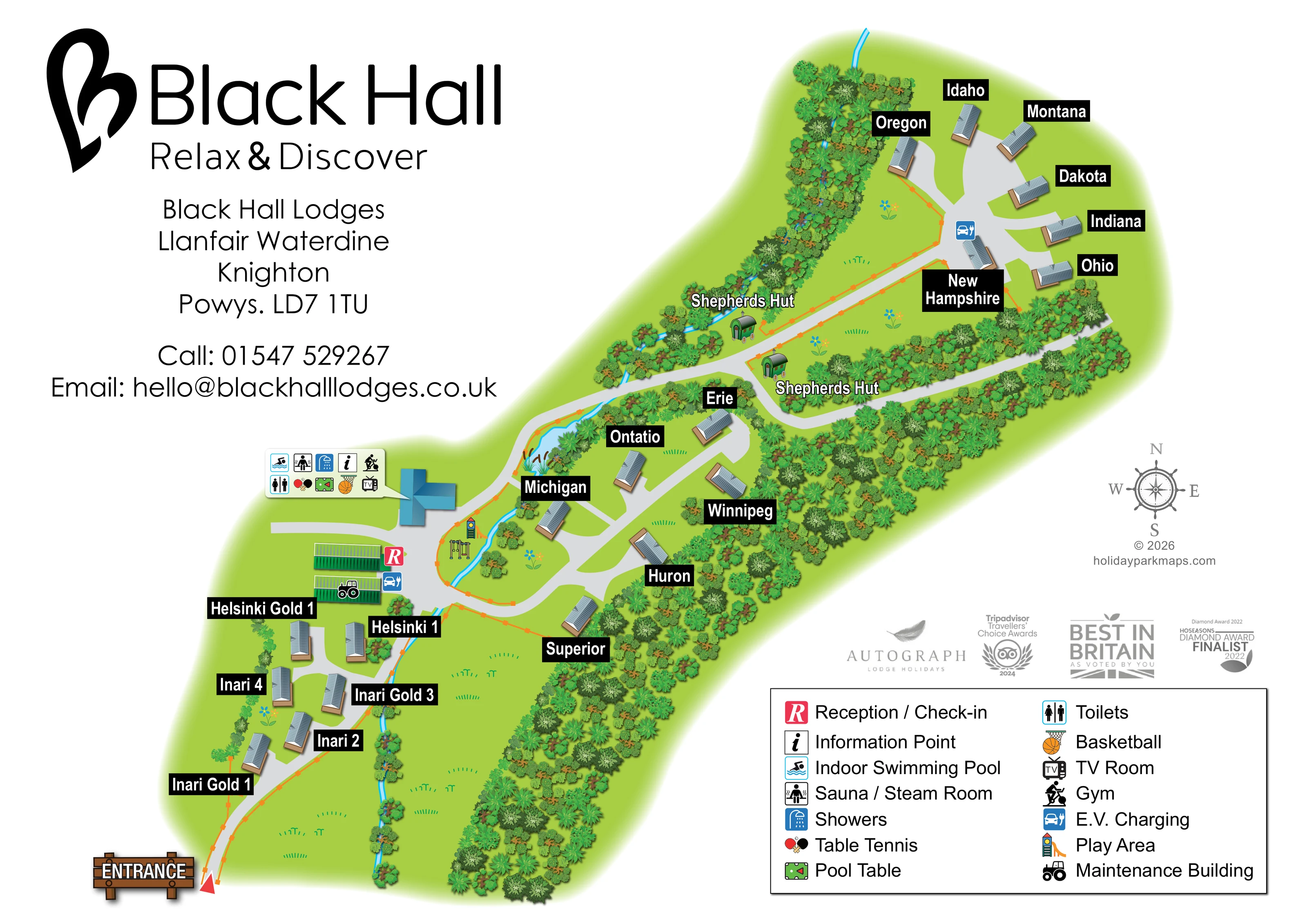
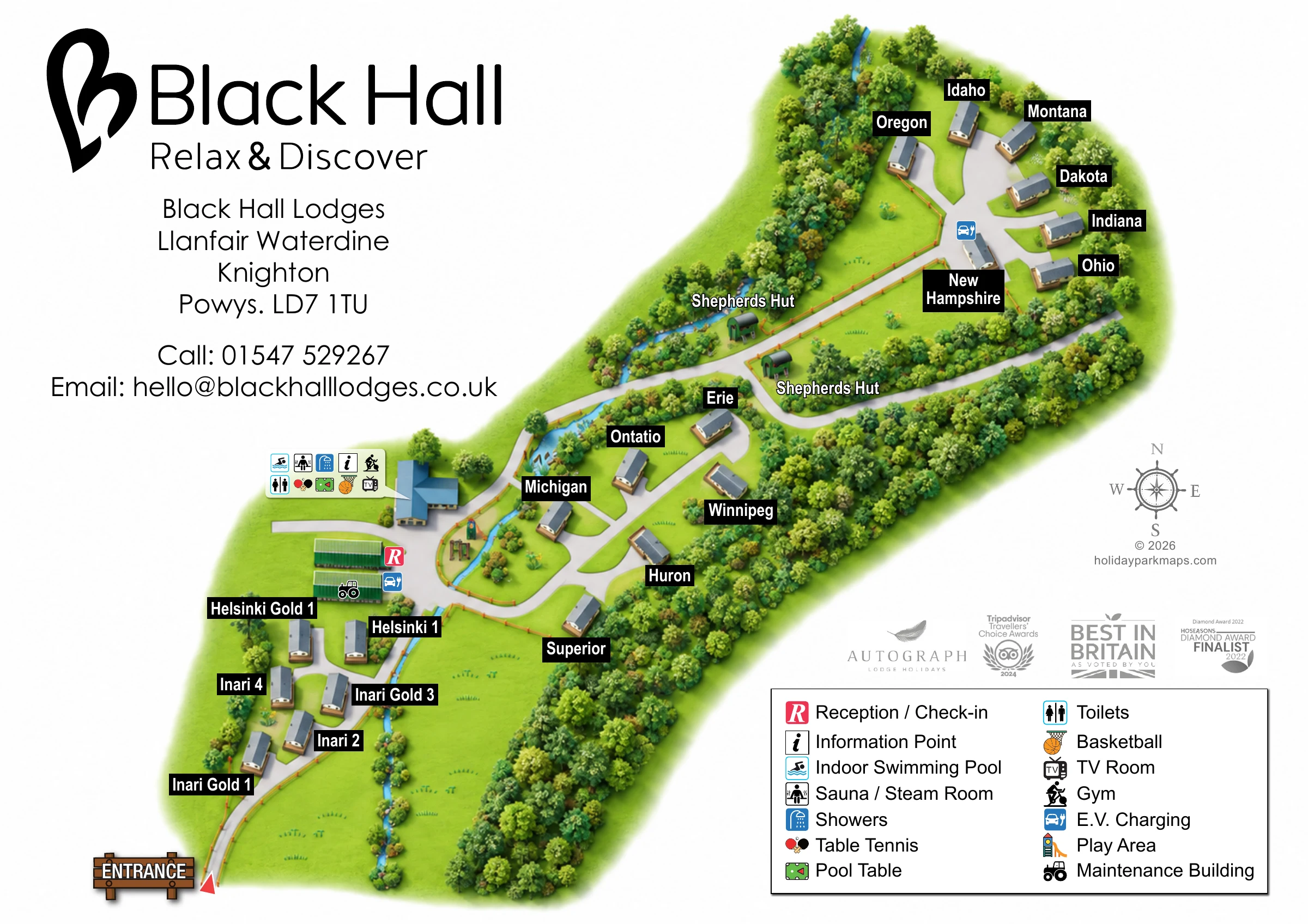
This illustrated map of Black Hall Lodges presents a small countryside retreat at Llanfair Waterdine, near Knighton on the Welsh border. Rather than treating the accommodation as a grid of pitches, the design gives each lodge a prominent name and places it within a landscape of open grass, wooded edges and a winding blue stream. Two green shepherds' huts add a distinct accommodation detail between the main lodge groups.
The plan follows the site diagonally from a timber-style entrance sign at the lower left to the upper lodge cluster. Reception, the shared leisure building and the play area form a clear central destination, with electric vehicle charging marked in two parts of the park. A compact facility callout connects the leisure building to its swimming, relaxation, games and exercise symbols.
Large Black Hall branding occupies the white space beside the plan, while a generous legend explains the visitor symbols. The result is a useful sample for lodge parks that need to combine named-unit wayfinding with a strong sense of their rural setting.
The single landscape-format plan shows an elongated site extending from the bottom-left entrance towards the upper-right corner. A pale grey arrival road runs past the Inari and Helsinki lodge group before reaching the green-roofed reception and maintenance buildings. The red reception marker and nearby blue charging symbol make this service area easy to distinguish from the accommodation.
Just beyond it, a blue-roofed leisure building sits beside a bend in the road. A pale callout points to the building and groups the symbols for an indoor swimming pool, sauna or steam room, showers, toilets, information, gym, table tennis, pool table, basketball and TV room. Across the road, illustrated swings and a slide tower identify the play area beside the stream. The middle lodge group spreads around short road branches, with individual names displayed in large black label panels.
The connecting lane continues past two shepherds' huts to a further group of named lodges, including Oregon, Idaho and Montana. Another charging symbol appears here, and a return road curves around the wooded strip below this group. Grey pitched roofs and tan bases give the lodges a consistent visual identity; the huts are differentiated by green curved roofs and wheels.
Dense tree canopies frame the site and trace the bright blue watercourse. A reed-fringed widening adds a recognisable landscape landmark near the middle accommodation. Orange post-and-rail lines reinforce selected boundaries, while grass and flower motifs soften the open spaces.
The surrounding white page carries the large park logo, contact block, decorative compass and award marks. A boxed two-column legend anchors the lower-right corner without obscuring the roads or lodge names.
 Enlarge this map ↗
KEEP EXPLORING
Chosen for shared landscapes, accommodation or facilities.
 Explore the map ↗
United Kingdom
Woodland park map with mixed pitches, bell tents, lodges and a fishing lake.
 Explore the map ↗
United Kingdom
Illustrated farm campsite map with touring pitches, pods, camping fields and a riverside dog-walk route.
 Explore the map ↗
United Kingdom
A woodland estate park map combining caravan loops, touring pitches, riverside paths and Bruce’s Cave landmarks.
Features may come from the sample artwork, its key or published park information. Approximate numbers describe the drawing and may cover only part of a park. They are intended to help you compare map examples. Current facilities and booking information should be checked with the park.
TAKE A CLOSER LOOK
View the illustrated map in detail or choose a file to download. These are sample maps; contact the park for current visitor information.

LET’S MAP YOUR PARK
For a map quotation, find your park and draw a rough boundary around it. The area you select helps us work out the design time and price.
Draw your park for a quote ↗Or talk to our map designers
01751 473136