
Sightseeing points
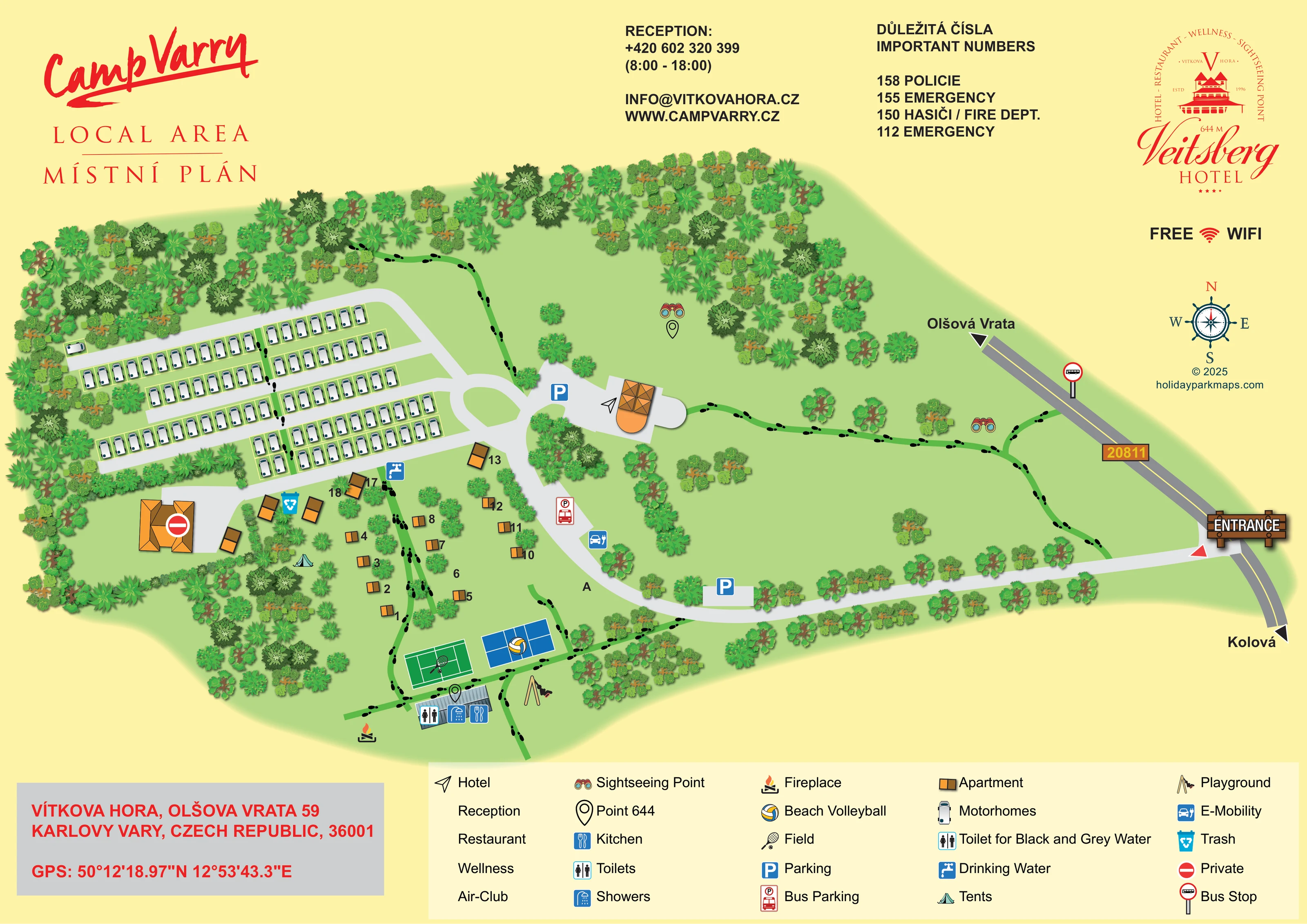
Binocular symbols identify sightseeing points in the open northern and eastern grounds.
ILLUSTRATED PARK MAP · P060
Olšová Vrata 59, Karlovy Vary · Czechia
 Enlarge the map ↗
A SENSE OF THE PLACE
Camp Vary – Vítkova Hora is based at Olšová Vrata 59, Karlovy Vary. The campsite is above the Karlovy Vary spa area, with views towards the town. The operator describes 45 beds in cabins, plus space for guests bringing tents or caravans.
A shared sanitary block has toilets and hot showers; showers carry an additional charge. Facilities include a multi-use court, beach volleyball, table tennis and children’s climbing and swing equipment. The wellness area lists a whirlpool and infrared sauna, with massages available by arrangement.
LOOK CLOSER
Binocular symbols identify sightseeing points in the open northern and eastern grounds.
Outline pin symbols correspond to the legend entry 'Point 644', including a marker beneath the northern sightseeing symbol. No contours or measured relief accompany them.
Dense bands of illustrated trees enclose the western and northern areas, with scattered trees, planted dividers and open lawns elsewhere.
An orange-roofed building beside the central turning loop carries the hotel's identifying symbol.
Reception is named in the upper contact panel and the legend, but its precise location is not separately marked.
Restaurant appears in the hotel branding and legend, without a distinct mapped location.
Wellness is named in the hotel branding and legend; individual wellness facilities are not illustrated.
A grey-roofed block below the sports courts is marked with toilets, showers and kitchen symbols.
An orange-roofed building beside the central turning loop carries the hotel's identifying symbol.
Reception is named in the upper contact panel and the legend, but its precise location is not separately marked.
Restaurant appears in the hotel branding and legend, without a distinct mapped location.
Wellness is named in the hotel branding and legend; individual wellness facilities are not illustrated.
Air-Club is listed in the legend without a recognisable separate location in the plan.
A grey-roofed block below the sports courts is marked with toilets, showers and kitchen symbols.
The legend names a 'Toilet for Black and Grey Water' using the same pictogram as the toilets entry. A distinct disposal position cannot be confidently separated from the sanitary-block marking.
A blue tap symbol marks drinking water near the boundary between the motorhome rows and apartment grounds.
A turquoise bin symbol appears among the larger accommodation buildings south of the motorhome area.
A green, white-lined court is illustrated with a racket and ball and identified as 'Field' in the legend.
A blue court with a volleyball symbol sits beside the green sports court.
A swing illustration marks the playground beside the southern amenity block and courts.
A flame-and-logs symbol identifies a fireplace to the south-west of the shared amenity block.
A blue car-and-plug symbol marks an electric-vehicle point beside the internal road near bus parking.
Blue parking symbols mark spaces near the hotel and entrance approach; a separate red pictogram identifies bus parking along the internal road.
A roadside bus-stop sign is placed on road 20811 above the campsite entrance.
A wooden-style entrance sign and red pointer mark the junction with road 20811. Direction arrows name Olšová Vrata and Kolová.
Green paths overlaid with black footprints connect the woodland edge, accommodation, sports area, hotel and eastern grounds.
Binocular symbols identify sightseeing points in the open northern and eastern grounds.
Outline pin symbols correspond to the legend entry 'Point 644', including a marker beneath the northern sightseeing symbol. No contours or measured relief accompany them.
Dense bands of illustrated trees enclose the western and northern areas, with scattered trees, planted dividers and open lawns elsewhere.
A red no-entry-style symbol, explained as 'Private', overlays a large building at the western edge of the apartment grounds.
A prominent 'Free WiFi' notice appears in the right-hand page margin, without showing coverage areas.
READING THE MAP
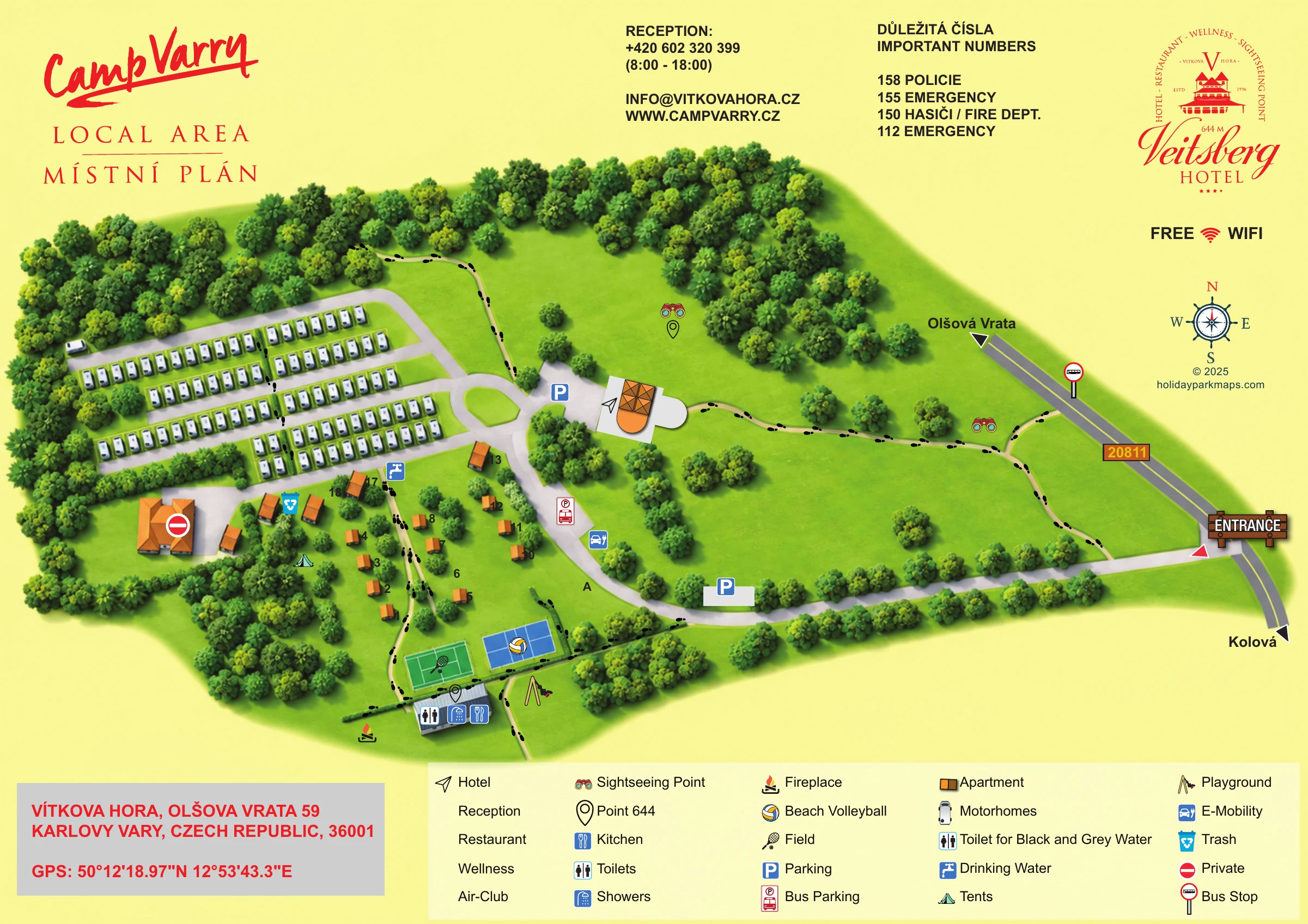
This illustrated map brings together the camping grounds and hotel setting of Camp Vary – Vítkova Hora, above the spa town of Karlovy Vary in Czechia. Branded Camp Varry on the artwork, the site is presented as a green, tree-framed landscape with a clear arrival route from road 20811 and walking paths leading through its grounds.
The plan contrasts orderly rows of motorhome bays with smaller apartment-style accommodation scattered among trees and lawns. A tent symbol indicates camping, while the central hotel building provides another recognisable landmark. Towards the bottom of the map, sports courts, a playground, an outdoor fireplace and a shared amenities building form a compact recreation and service area.
Black footprints make the walking routes particularly easy to distinguish from vehicle access. Sightseeing symbols draw attention to the open grounds, while blue pictograms pick out parking, water and other practical facilities. Red campsite and hotel branding, a bilingual title and a wide legend frame a map designed to explain several different visitor experiences on one page.
The single landscape-format map places the entrance on the right, where a wooden-style sign marks the junction with road 20811. Direction arrows point towards Olšová Vrata and Kolová, and a bus stop is shown beside the public road. From the entrance, a pale-grey drive runs along the lower edge of the grounds before curving towards the hotel and a central turning loop. Car parking, bus parking and an E-Mobility symbol are positioned along this network.
The western accommodation area is the most regular part of the drawing. Roughly 100 motorhome illustrations sit in narrow outlined bays beside parallel access lanes, with woodland around the outside and planting between some rows. Below them, approximately 15 orange-and-brown apartment symbols are arranged more loosely across lawns and among trees. A tent symbol identifies camping without implying individual pitch boundaries. A larger western building is marked private.
At the southern edge, a green racket-sport court and a blue beach-volleyball court sit above a grey-roofed block carrying toilets, showers and kitchen symbols. Nearby illustrations identify the playground and outdoor fireplace. Drinking water and a rubbish point are marked closer to the accommodation.
Green walking paths with black footprints link these areas to the hotel, woodland edge and eastern lawns. Binocular symbols identify sightseeing points, while outline pins correspond to 'Point 644' in the legend. The surrounding page carries dual branding, reception contact information, an emergency-number panel, a Wi-Fi notice, a compass and an address box. The bottom legend also names restaurant, wellness and Air-Club, although these are not individually located within the plan.
 Enlarge this map ↗
KEEP EXPLORING
Chosen for shared landscapes, accommodation or facilities.
 Explore the map ↗
United Kingdom
A wooded Allerton park plan with colour-coded neighbourhoods, touring pitches and a central facilities hub.
 Explore the map ↗
United States
Woodland RV campground map with mixed camping, three water landmarks and a central recreation hub.
 Explore the map ↗
United Kingdom
Woodland park map with mixed pitches, bell tents, lodges and a fishing lake.
Features may come from the sample artwork, its key or published park information. Approximate numbers describe the drawing and may cover only part of a park. They are intended to help you compare map examples. Current facilities and booking information should be checked with the park.
LET’S MAP YOUR PARK
For a map quotation, find your park and draw a rough boundary around it. The area you select helps us work out the design time and price.
Draw your park for a quote ↗Or talk to our map designers
01751 473136