
Palms and planted grounds
Palm-lined boundaries, dense palm groups, broadleaf trees and shrub rows separate pitches and frame the recreation areas.
ILLUSTRATED PARK MAP · P061
Carretera Transpeninsular Km 11, Chametla, La Paz, B.C.S · Mexico
 Enlarge the map ↗
A SENSE OF THE PLACE
Campestre Maranatha is based at Carretera Transpeninsular Km 11, Chametla, La Paz, B.C.S.
A swimming pool is described as used for recreation and baptisms. The campground is a field base for Maranatha Missions in Mexico. The operator hosts churches, schools and families, including youth camps, seminars, retreats and family gatherings.
LOOK CLOSER
Palm-lined boundaries, dense palm groups, broadleaf trees and shrub rows separate pitches and frame the recreation areas.
A curved planted courtyard sits inside the amenity complex, with additional winding green and stone-like beds near the lower parking area.
A blue R identifies a separate roofed building beside the central service complex and internal access lane.
Repeated toilet and shower symbols identify facilities within the connected central buildings, including the pool-side wings.
A washing-machine symbol marks laundry facilities on the long diagonal service building.
Blue tap symbols appear around the central facilities, beside the pool and farther up the grounds.
A cutlery symbol marks a detached elongated building near reception.
A turquoise rectangular pool with illustrated entry steps sits within a mauve surround beside the central amenity buildings; a smaller blue rectangle is also drawn nearby.
A blue R identifies a separate roofed building beside the central service complex and internal access lane.
Repeated toilet and shower symbols identify facilities within the connected central buildings, including the pool-side wings.
A washing-machine symbol marks laundry facilities on the long diagonal service building.
Blue tap symbols appear around the central facilities, beside the pool and farther up the grounds.
A cutlery symbol marks a detached elongated building near reception.
A turquoise rectangular pool with illustrated entry steps sits within a mauve surround beside the central amenity buildings; a smaller blue rectangle is also drawn nearby.
A grey court with white basketball markings lies to the left of the central facilities.
Black barbecue symbols appear beside the pool and within a circular arrangement of seating-like marks below the basketball court.
Straw-coloured parasol illustrations provide recognisable landmarks next to the pool.
Several blue P symbols identify parking around the lower grounds, including a white-lined bay area beside the highway frontage.
A red fire-point symbol marks a small structure beside the path leading away from the pool and service complex.
Two red-ringed 10 markers are shown on the main internal lane; no speed unit is stated.
Large red arrows and ENTRANCE labels mark two connections from the road along the right-hand boundary.
The highway is labelled across the bottom, with a Mexico 1 shield and directional arrows towards La Paz and El Centenario.
Grey vehicle lanes serve the RV rows and lower parking areas; pale paths link the central buildings, while ochre looped tracks surround buildings in the upper grounds.
Palm-lined boundaries, dense palm groups, broadleaf trees and shrub rows separate pitches and frame the recreation areas.
A curved planted courtyard sits inside the amenity complex, with additional winding green and stone-like beds near the lower parking area.
Grey and tan roofed structures are scattered through the upper and lower grounds; functions are not assigned to the unlabelled buildings.
The secondary legend defines gold powered-site and green unpowered-site markers, without clearly locating these categories in the main plan.
READING THE MAP
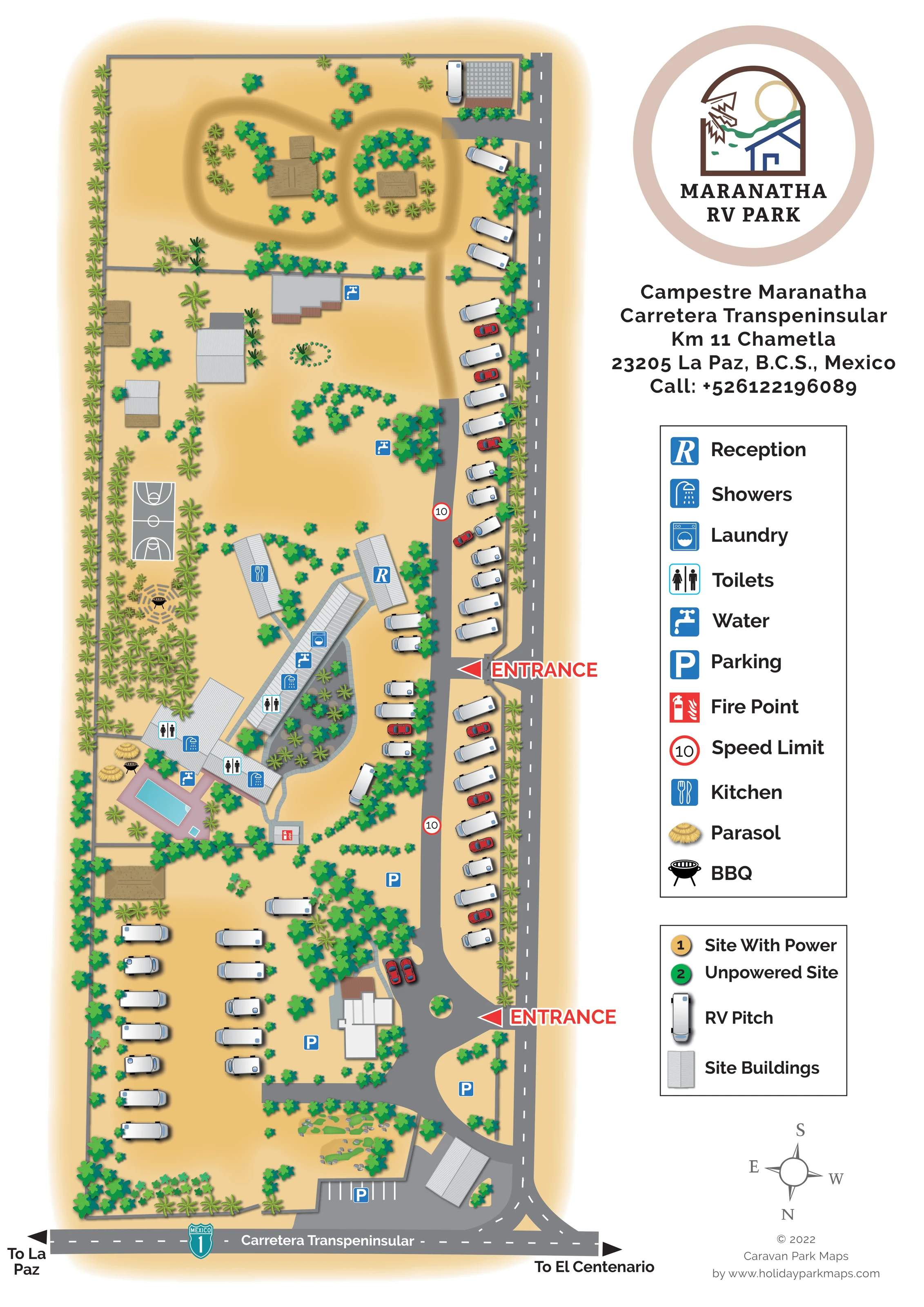
This illustrated map of Campestre Maranatha presents a palm-planted RV park at Chametla, near La Paz in Baja California Sur, Mexico. Its long roadside layout is shown in a warm sand-and-green palette, with white RV illustrations making the accommodation areas immediately recognisable. The plan depicts roughly 45 RV pitches, arranged along a narrow boundary strip and in more open internal rows.
The central facilities are a strong visual focus. Reception, a kitchen, laundry, toilets and showers sit close to a turquoise swimming pool, while a basketball court and barbecue areas give the grounds a clear recreational character. Palms and broadleaf trees frame these spaces rather than appearing as a uniform background texture.
Two bold entrance arrows connect the site to the road on its right-hand edge. Along the bottom, Carretera Transpeninsular, a Mexico 1 shield and arrows towards La Paz and El Centenario place the park in its local road context. A separate right-hand column holds the Maranatha branding, contact details and generous symbol keys, keeping the illustrated grounds relatively uncluttered.
The artwork is a single portrait plan with the park occupying the left side and a white information panel on the right. Its compass places south at the top, so the page should be read by its stated orientation rather than assuming north-up. The lower road is labelled Carretera Transpeninsular and carries a Mexico 1 shield, with outward arrows towards La Paz and El Centenario.
A road follows the right-hand boundary, where two large red ENTRANCE arrows lead into the grounds. Inside, a grey lane runs beside a long line of angled RV pitches. Shorter RV rows sit near the central buildings, and the lower-left section has more widely spaced vehicles among trees. Parking symbols appear around this lower section, including marked bays near the highway. Red-ringed 10 signs punctuate the internal lane.
The central amenity group is drawn as a series of elongated, angled roof forms around a curved planted courtyard. Blue symbols identify reception, kitchen and laundry, with repeated toilet, shower and water symbols across the complex. A pale path links this area to a mapped fire point. To the left, a rectangular turquoise swimming pool occupies a mauve surround with parasols and a barbecue. Farther up, a basketball court and another barbecue gathering area sit within palm planting.
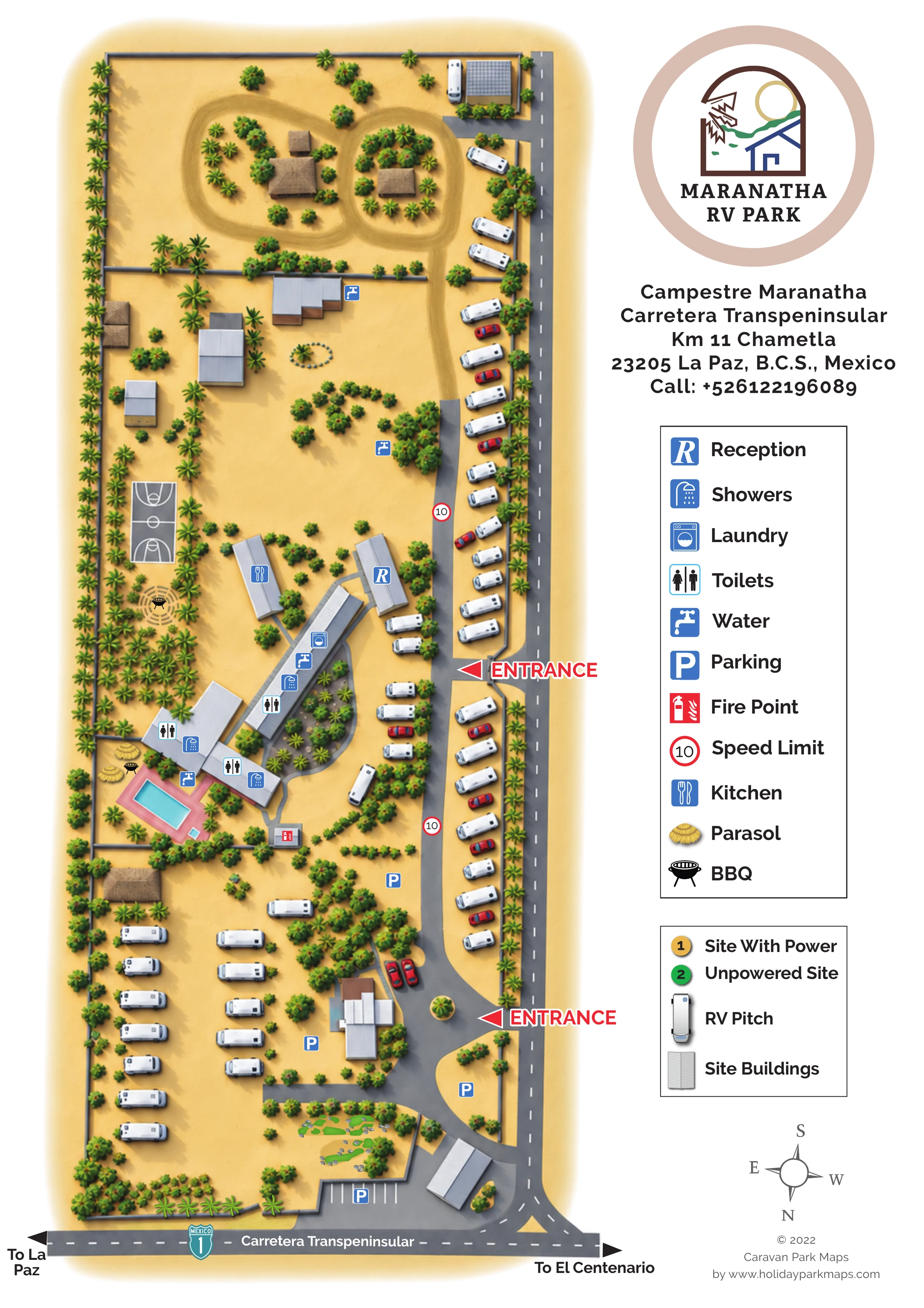
The upper grounds are more open, with scattered buildings, water points and ochre looped tracks around two planted building groups. Grey boundaries, palm rows and dense green canopies organise the sandy site. Two legend boxes explain facilities and accommodation symbols; powered and unpowered categories are included in the key but are not clearly assigned to pitches. The accompanying enlarged views show overlapping portions of this same artwork, not additional park sections.
 Enlarge this map ↗
KEEP EXPLORING
Chosen for shared landscapes, accommodation or facilities.
 Explore the map ↗
United Kingdom
Colour-coded campsite map with riverside pitches, bell tents, a swimming pool and fishing lake.
 Explore the map ↗
United Kingdom
Coastal park map with static-caravan rows, touring pitches, a camping field and two leisure clusters.
 Explore the map ↗
United States
Woodland RV campground map with mixed camping, three water landmarks and a central recreation hub.
Features may come from the sample artwork, its key or published park information. Approximate numbers describe the drawing and may cover only part of a park. They are intended to help you compare map examples. Current facilities and booking information should be checked with the park.
LET’S MAP YOUR PARK
For a map quotation, find your park and draw a rough boundary around it. The area you select helps us work out the design time and price.
Draw your park for a quote ↗Or talk to our map designers
01751 473136