
Tree-lined boundaries and internal planting
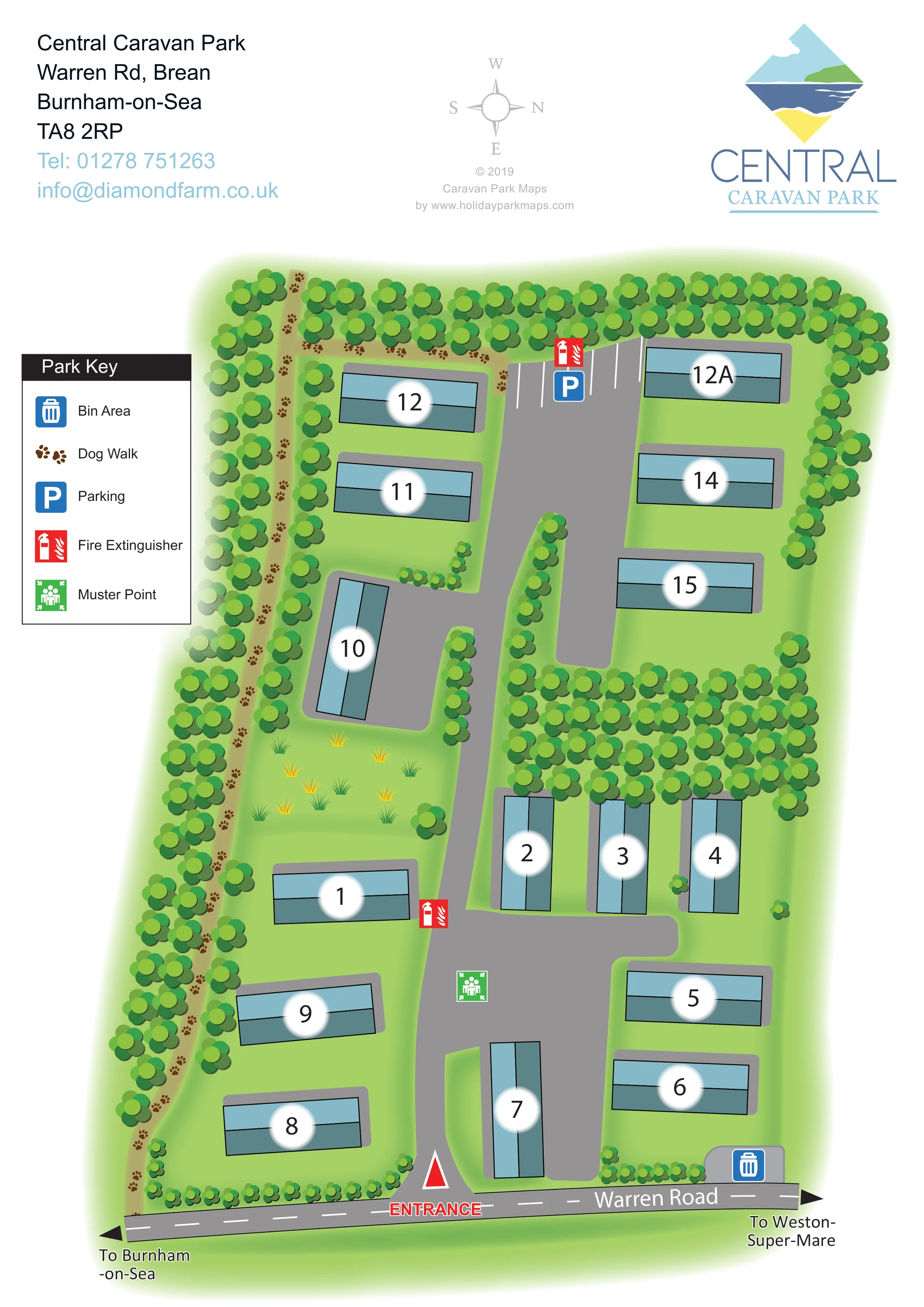
Continuous tree symbols define much of the perimeter; a dense crosswise belt separates the upper-right accommodation from the central group.
ILLUSTRATED PARK MAP · P442
Central Caravan Park, Warren Rd, Brean, Burnham-on-Sea · United Kingdom
 Enlarge the map ↗
A SENSE OF THE PLACE
Central Caravan Park is based at Warren Rd, Brean, Burnham-on-Sea. This is a small static-caravan holiday park operated by Diamond Farm.
The map brings the site layout and its access routes together in one view, providing a reference for understanding the arrangement of the grounds.
LOOK CLOSER
Continuous tree symbols define much of the perimeter; a dense crosswise belt separates the upper-right accommodation from the central group.
Light-green ground surrounds the caravans, with smaller shrubs, planted road margins and a patch of decorative grass tufts left of the central lane.
A tan path marked with repeated brown paw prints runs along the left-hand boundary and continues across the upper edge, enclosed by illustrated trees.
White-lined parking bays and a blue parking symbol mark the upper end of the internal road.
A blue bin symbol marks an area beside Warren Road at the lower-right edge of the park.
Red fire extinguisher symbols appear beside the central lane and at the upper parking area.
A green assembly symbol identifies a muster point on the widened lower section of the internal road.
The entrance is labelled in red at the bottom of the plan, with a red triangular marker at the start of the internal lane.
A tan path marked with repeated brown paw prints runs along the left-hand boundary and continues across the upper edge, enclosed by illustrated trees.
White-lined parking bays and a blue parking symbol mark the upper end of the internal road.
A blue bin symbol marks an area beside Warren Road at the lower-right edge of the park.
Red fire extinguisher symbols appear beside the central lane and at the upper parking area.
A green assembly symbol identifies a muster point on the widened lower section of the internal road.
The entrance is labelled in red at the bottom of the plan, with a red triangular marker at the start of the internal lane.
Warren Road spans the bottom of the map, with directional arrows towards Burnham-on-Sea on the left and Weston-super-Mare on the right.
A broad grey lane extends from the entrance towards the upper parking bays, with short branches and widened areas serving the caravans.
Continuous tree symbols define much of the perimeter; a dense crosswise belt separates the upper-right accommodation from the central group.
Light-green ground surrounds the caravans, with smaller shrubs, planted road margins and a patch of decorative grass tufts left of the central lane.
READING THE MAP
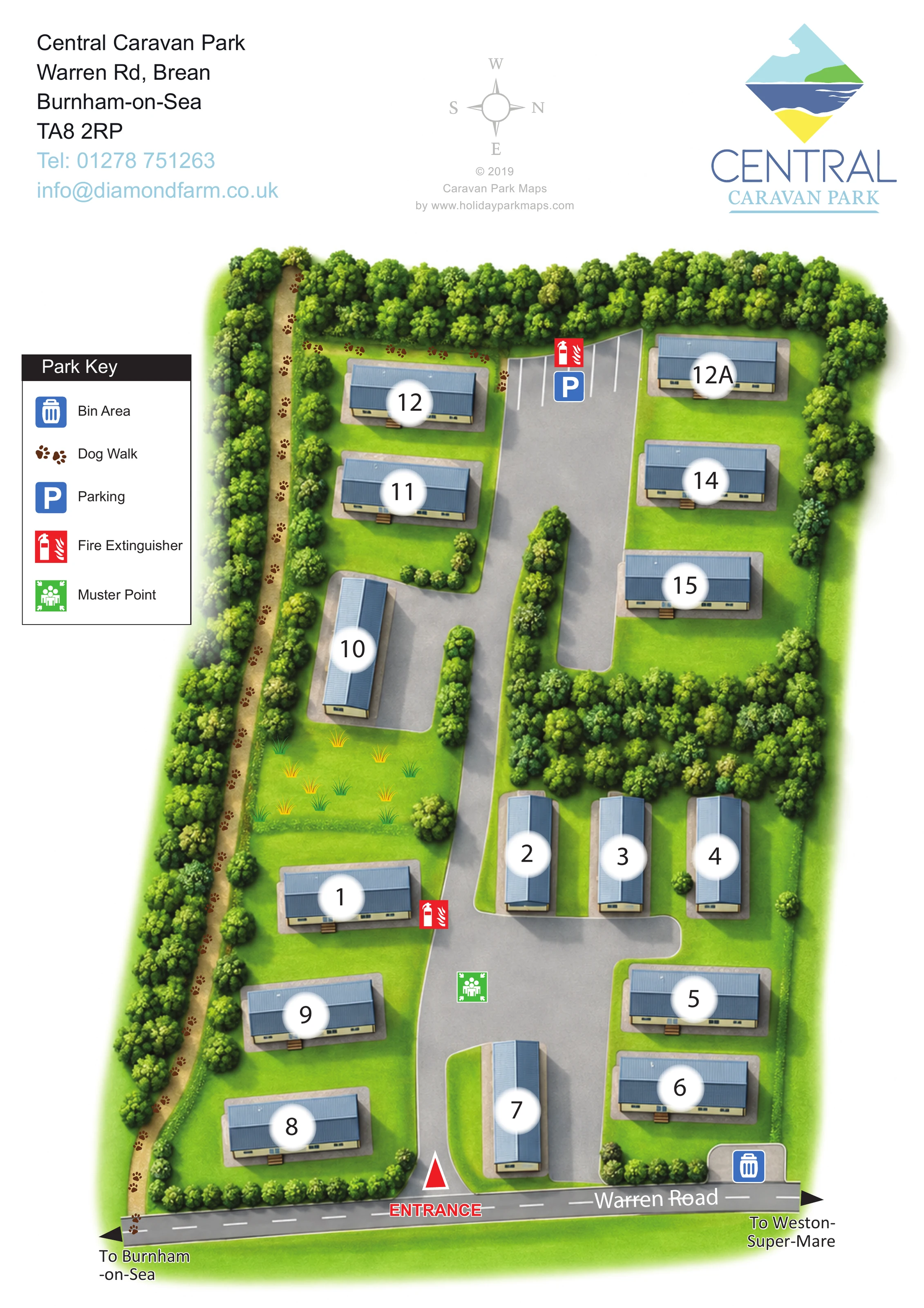
This illustrated map of Central Caravan Park presents a small static-caravan site on Warren Road in Brean, near Burnham-on-Sea. Its compact layout is built around a grey access lane, with roughly 15 caravans shown in small groups among grassed spaces and substantial tree planting. Large accommodation numbers make the individual units easy to pick out without crowding the drawing with text.
The map gives particular attention to arrival and everyday orientation. Warren Road stretches across the bottom of the page, the entrance is highlighted in red, and arrows indicate the directions towards Burnham-on-Sea and Weston-super-Mare. Inside the park, coloured symbols locate parking, the bin area, fire extinguisher points and a muster point. A distinctive paw-print trail follows the tree-lined dog walk along the left and upper boundaries.
The portrait page pairs a practical site plan with a generous branded header and a compact five-item key. Pale-blue caravan roofs, layered green tree canopies and softly shaded lawn areas give this small park a recognisable visual character while keeping the routes and accommodation prominent.
The plan shows an elongated park entered from Warren Road at the bottom of the page. A central grey lane leads through the accommodation towards a white-lined parking area at the upper end. Short branches and widened sections provide access to the caravan bases, while the units themselves sit at varied angles on either side of the lane. This produces a more informal arrangement than a strict row-and-column plan.
Each caravan is drawn as a simple black-outlined rectangle with two blue roof tones, a grey surrounding base and a large number on a softly edged white disc. The lower part of the site contains several units around the broader entrance-side roadway. Further up, a dense band of trees separates the central accommodation from the upper-right group. Open grass, small shrubs and a patch of illustrated grass tufts fill the spaces between the access routes and units.
The dog walk is one of the clearest landscape features. A tan strip threaded with brown paw prints follows the left boundary and turns across the top, with trees framing the route. The legend explains this trail alongside four coloured facility symbols. Parking is marked at the upper end, the bin area beside the road frontage, fire extinguisher points beside the lane and parking area, and the muster point on the lower widened roadway.
Above the plan, contact details, a rotated compass and the park’s diamond-shaped coastal logo occupy a white header. The compass establishes west at the top rather than a conventional north-up orientation. The accompanying enlarged view shows the same artwork’s legend and left-hand dog-walk detail, not a separate park section or additional accommodation.
 Enlarge this map ↗
KEEP EXPLORING
Chosen for shared landscapes, accommodation or facilities.
 Explore the map ↗
United Kingdom
Ashby Park map with seven fishing lakes, colour-coded accommodation and illustrated wooded shorelines.
 Explore the map ↗
United Kingdom
Woodland-framed Barnsoul map with mixed accommodation, shared facilities and paw-marked walking routes.
 Explore the map ↗
United Kingdom
Coastal park plan with colour-coded pitches, named neighbourhoods and a Morecambe Bay walking route.
Features may come from the sample artwork, its key or published park information. Approximate numbers describe the drawing and may cover only part of a park. They are intended to help you compare map examples. Current facilities and booking information should be checked with the park.
TAKE A CLOSER LOOK
View the illustrated map in detail or choose a file to download. These are sample maps; contact the park for current visitor information.


LET’S MAP YOUR PARK
For a map quotation, find your park and draw a rough boundary around it. The area you select helps us work out the design time and price.
Draw your park for a quote ↗Or talk to our map designers
01751 473136