
Landscaped home plots
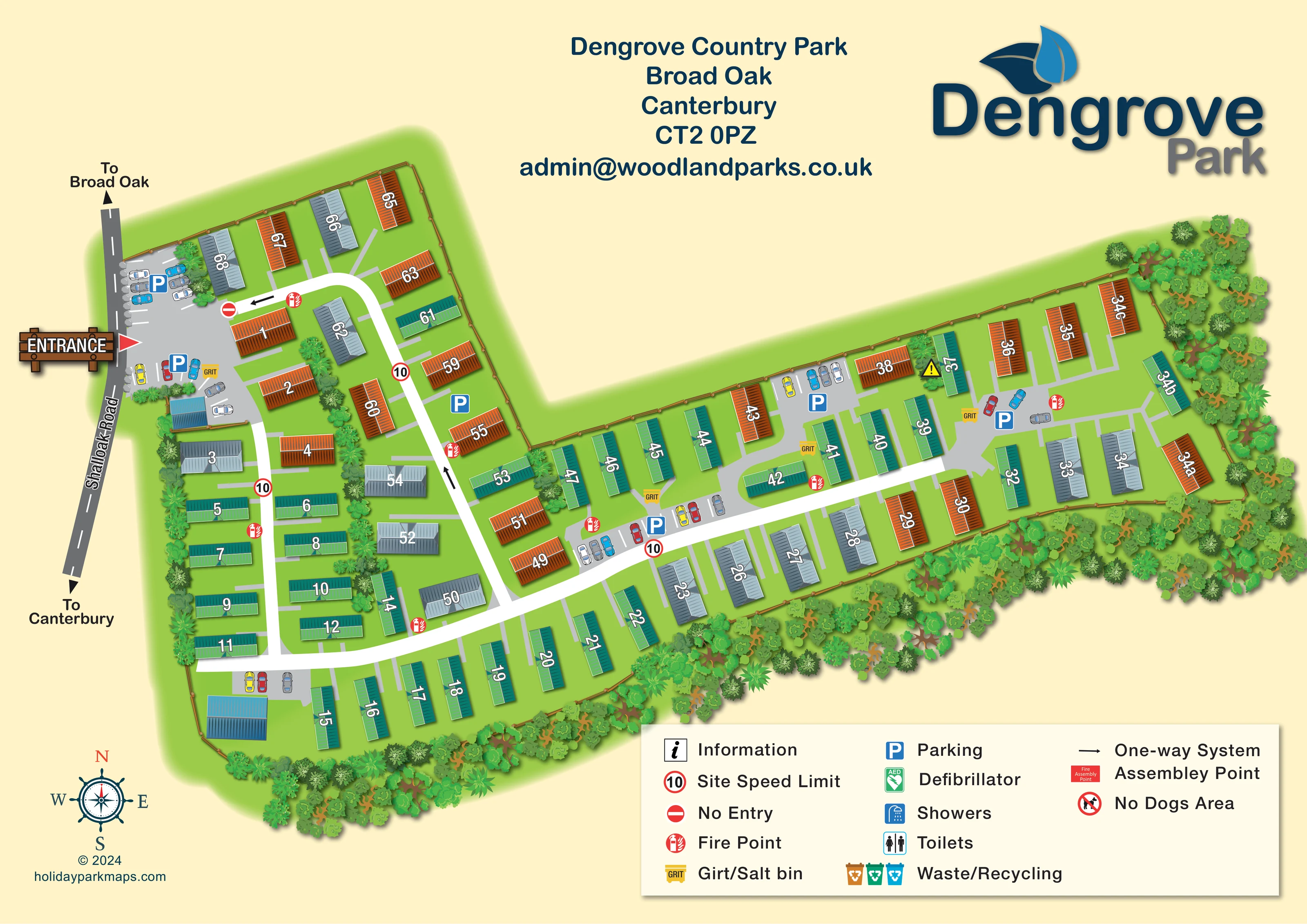
Homes sit on green plots with short grey access strips; shrubs and small trees divide some rows and soften the roadside edge.
ILLUSTRATED PARK MAP · P099
Dengrove Country Park, Broad Oak, Canterbury · United Kingdom
 Enlarge the map ↗
A SENSE OF THE PLACE
Dengrove Country Park is based at Broad Oak, Canterbury. The site is situated in Broad Oak on the edge of Canterbury. The operator describes a residential park-home community.
Homes occupy individual private plots in landscaped grounds. The operator identifies a village convenience store, pub and bus connections into Canterbury.
LOOK CLOSER
Homes sit on green plots with short grey access strips; shrubs and small trees divide some rows and soften the roadside edge.
Dense overlapping tree canopies form a substantial illustrated belt along the lower boundary and around the eastern end.
A fine brown post-and-rail boundary follows much of the irregular site outline.
A timber-style ENTRANCE sign and red pointer identify the western arrival point beside the roadside parking apron.
Shalloak Road is named along the left edge, with Broad Oak indicated upwards and Canterbury downwards.
White internal roads connect the western residential block with the elongated eastern arm; grey spurs and parking courts serve smaller groups of homes.
Blue P symbols, marked bays and illustrated cars identify parking at the entrance and in several courts throughout the plan.
Black arrows mark a one-way route on the western side, a no-entry symbol appears at its roadside end, and repeated red-ringed 10 signs mark the illustrated site speed limit.
A timber-style ENTRANCE sign and red pointer identify the western arrival point beside the roadside parking apron.
Shalloak Road is named along the left edge, with Broad Oak indicated upwards and Canterbury downwards.
White internal roads connect the western residential block with the elongated eastern arm; grey spurs and parking courts serve smaller groups of homes.
Blue P symbols, marked bays and illustrated cars identify parking at the entrance and in several courts throughout the plan.
Black arrows mark a one-way route on the western side, a no-entry symbol appears at its roadside end, and repeated red-ringed 10 signs mark the illustrated site speed limit.
Repeated red fire-point symbols are distributed beside roads and parking areas.
Yellow GRIT symbols appear near the entrance and several internal parking courts.
Homes sit on green plots with short grey access strips; shrubs and small trees divide some rows and soften the roadside edge.
Dense overlapping tree canopies form a substantial illustrated belt along the lower boundary and around the eastern end.
A fine brown post-and-rail boundary follows much of the irregular site outline.
Two unnumbered blue-roofed structures appear in the western part of the site. Their functions are not stated.
A yellow triangular exclamation marker appears beside a home in the upper eastern row, without an accompanying explanation in the key.
An information symbol is included in the legend; no corresponding location is clearly marked on the plan.
A green AED symbol is included in the legend, without a clearly identifiable plotted position.
Separate shower and toilet symbols appear in the key, but are not clearly positioned within the site.
A group of coloured waste and recycling bins is shown in the legend rather than at an identifiable mapped location.
A red fire assembly point symbol appears in the legend; a site position is not clearly shown.
The legend contains a no-dogs-area symbol, but no matching area is clearly marked. This does not establish a park-wide pet policy.
READING THE MAP
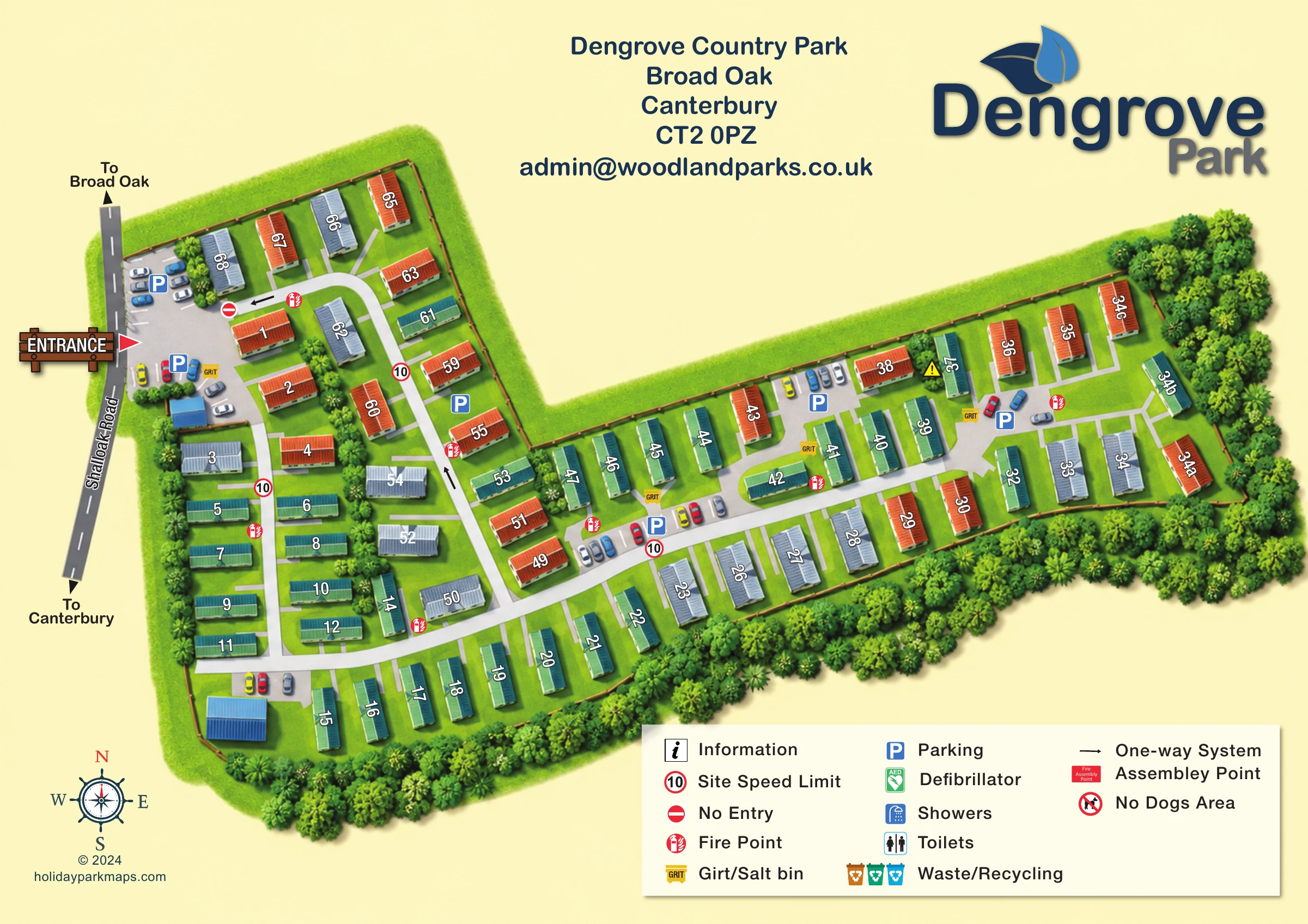
This illustrated map of Dengrove Country Park presents a residential park-home community at Broad Oak, on the edge of Canterbury. Its distinctive shape combines a compact entrance-side block with a long arm of homes extending eastwards, all brought together on a warm cream page. A substantial tree-lined boundary gives the drawing its green character, while individual homes remain easy to pick out through large roof-mounted numbers.
The map places everyday navigation ahead of resort-style attractions. Shalloak Road, directions towards Broad Oak and Canterbury, a prominent entrance sign and several parking areas establish the arrival sequence. Within the grounds, white roads stand out against green plots, with smaller grey access strips and parking courts serving groups of homes. Fire points, grit bins and traffic symbols add practical detail without overwhelming the residential layout.
The design also makes room for a large Dengrove Park logo, an address and contact block, a compass rose and a clearly separated symbol key. It is a useful sample for residential park operators seeking an illustrated plan that combines individual plot identification, vehicle access and a landscaped setting.
The single-page plan shows the site as an irregular, broadly L-shaped arrangement. Shalloak Road runs along the left edge, with arrows pointing towards Broad Oak above and Canterbury below. A timber-style entrance sign and red pointer mark the arrival area, where illustrated cars, parking bays and blue P symbols define the roadside apron.
Inside the boundary, the western homes sit in rows around two north–south roads and a curved upper connection. A broad white road crosses the lower part of this block before continuing through the long eastern section. Grey branches lead into parking courts between groups of homes, while short grey strips connect individual plots to the circulation network. The eastern end narrows into a cluster of differently oriented homes enclosed by trees and fencing.
Approximately 60 residential home symbols give the drawing a medium-sized community scale. Teal-green, orange-brown and blue-grey roof treatments distinguish the buildings visually, without defining separate accommodation types. White numbers are placed directly on the roofs. Two unnumbered blue-roofed buildings appear in the western area, but their uses are not labelled.
The operational symbols that are clearly positioned include parking, fire points, yellow grit bins, red-ringed speed-limit signs, one-way arrows and a no-entry marker. A yellow warning triangle also appears in the upper eastern row. The lower-right legend additionally includes information, a defibrillator, showers, toilets, waste and recycling, an assembly point and a no-dogs-area symbol; these entries do not have clearly identifiable positions on the plan.
Layered tree canopies, smaller shrubs and a fine brown boundary fence frame the numbered homes. The upper address block and large leaf-logo branding balance the diagonal site drawing, while the compass and designer credit complete the lower-left corner.
 Enlarge this map ↗
KEEP EXPLORING
Chosen for shared landscapes, accommodation or facilities.
 Explore the map ↗
United Kingdom
Illustrated Sanday aire map with a seasonal maze, café barn and motorhome service area.
 Explore the map ↗
United Kingdom
Illustrated coastal campsite plan with named fields, electric pitch colours, beach routes and the Afon Hen.
 Explore the map ↗
United Kingdom
A woodland touring-park map with colour-coded pitches, a stream and footprint-marked walks.
Features may come from the sample artwork, its key or published park information. Approximate numbers describe the drawing and may cover only part of a park. They are intended to help you compare map examples. Current facilities and booking information should be checked with the park.
LET’S MAP YOUR PARK
For a map quotation, find your park and draw a rough boundary around it. The area you select helps us work out the design time and price.
Draw your park for a quote ↗Or talk to our map designers
01751 473136