
Beach and coastal water
A broad cyan water band and pale yellow shoreline frame the top of the page.
ILLUSTRATED PARK MAP · P113
84 Evangeline Beach Road, Wolfville, Nova Scotia · Canada
 Enlarge the map ↗
A SENSE OF THE PLACE
Evangeline Beach Campground & Resort is based at 84 Evangeline Beach Road, Wolfville, Nova Scotia. The site is set beside Evangeline Beach with ocean views. The park offers overnight and seasonal camping, including unserviced and powered/water-serviced pitches.
Facilities include a pool, playground, arcade, mini-golf, shop and coin-operated showers/laundry.
LOOK CLOSER
A broad cyan water band and pale yellow shoreline frame the top of the page.
Dense layered tree symbols occupy much of the eastern side, with smaller trees scattered between pitches and along roadside edges.
A brown illustrated fence crosses the open T area between its two broad pitch rows.
Information-style office symbol beside the entrance and swimming pool.
Blue rectangular pool with a pale surround and swimmer symbol in the entrance-side recreation area.
Illustrated swing and seesaw beside the swimming pool.
Flag-and-hole symbol near area B, beside the road leading towards the beach.
Blue cup symbol near area B and the beach direction marker, identified as a canteen in the legend.
Information-style office symbol beside the entrance and swimming pool.
Blue rectangular pool with a pale surround and swimmer symbol in the entrance-side recreation area.
Illustrated swing and seesaw beside the swimming pool.
Flag-and-hole symbol near area B, beside the road leading towards the beach.
Blue cup symbol near area B and the beach direction marker, identified as a canteen in the legend.
Bathroom symbols appear in the central amenity cluster and near the approach to area L.
Shower symbol in the central cluster alongside bathrooms, laundry and firewood.
Washing-machine symbols identify laundry points in the central amenity cluster and near area L.
Firewood symbol beside the central bathroom, shower and laundry facilities.
Snowflake symbol beside the office near the entrance.
Paired rubbish-bin and recycling symbols occur at an upper internal junction and near the facilities serving area L.
Selected pitch lanes are labelled 3-WAY 30AMP, 2-WAY 30AMP and 2-WAY 15AMP, accompanied by yellow lightning symbols. Area T is labelled Unserviced.
Listed in the legend; no corresponding position is clearly identifiable on the main plan.
A broad cyan water band and pale yellow shoreline frame the top of the page.
Dense layered tree symbols occupy much of the eastern side, with smaller trees scattered between pitches and along roadside edges.
A brown illustrated fence crosses the open T area between its two broad pitch rows.
Large timber-style entrance sign and red pointer beside Bayview Rd., close to area A and the office.
Bayview Rd. follows the western edge, Evangeline Beach Road continues towards the coast, and Cottage Row branches off to the west.
A To the Beach arrow marks a short branch from Evangeline Beach Road near area B.
A To Wolfville arrow appears at the southern end of the grey roadside route.
The far end of the upper grey road is marked No Access.
Decorative nautical compass at the lower left, with north pointing towards the top of the page.
READING THE MAP
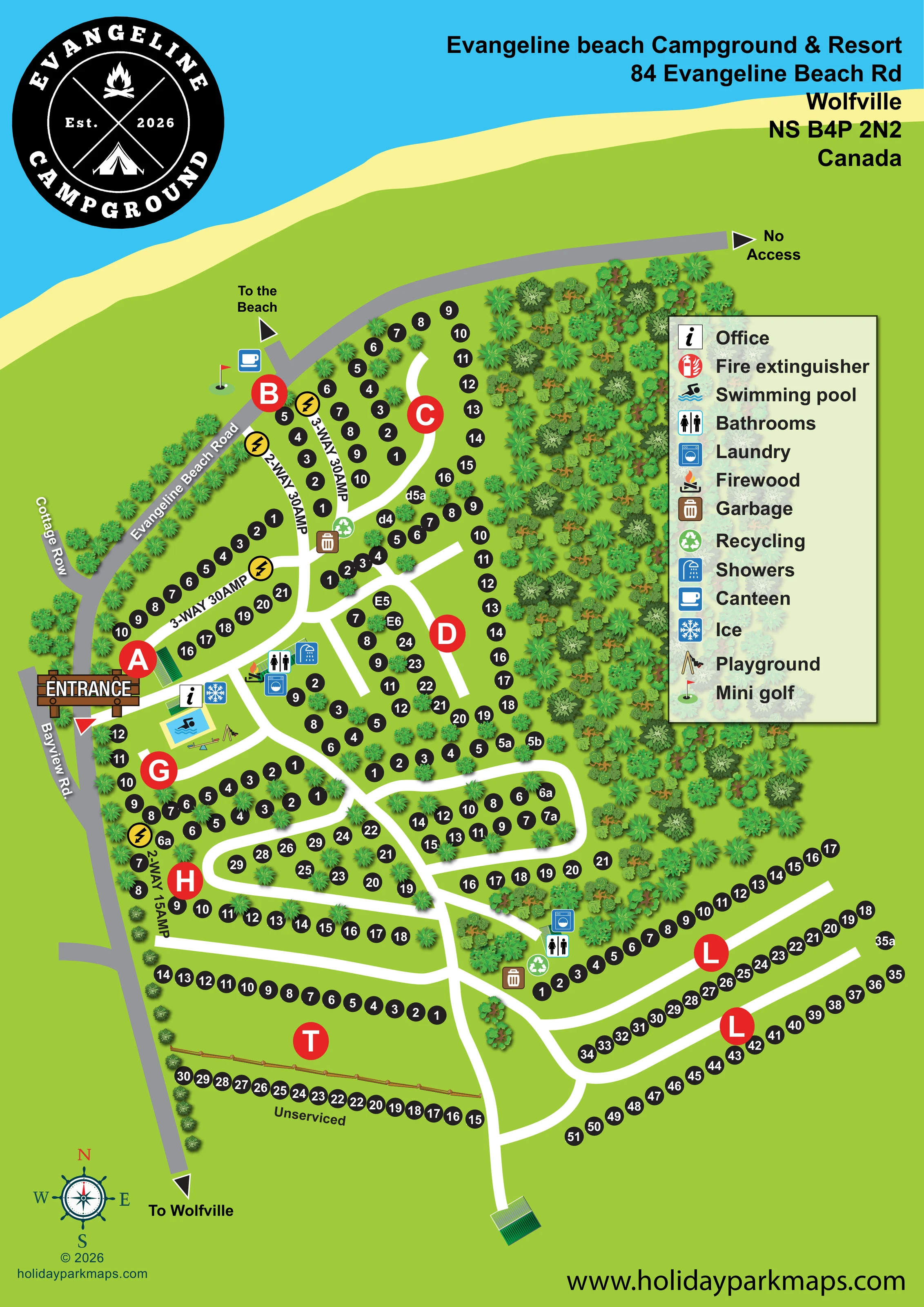
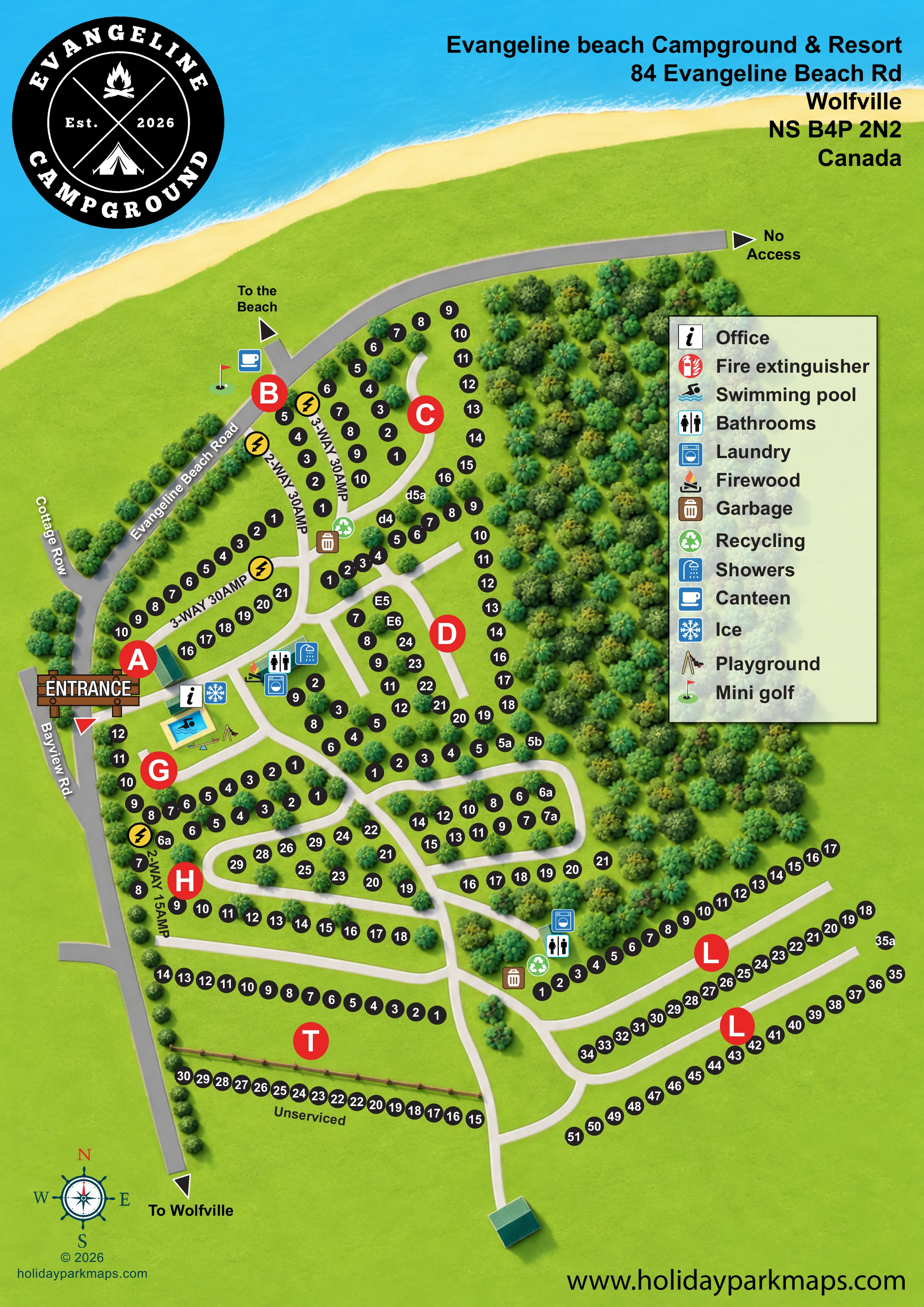
This campground map places Evangeline Beach Campground & Resort within its coastal setting near Wolfville, Nova Scotia. A sweep of blue water and pale yellow beach frames the top of the portrait page, while the camping areas spread below through green grounds and illustrated trees. The plan brings together roughly 250 numbered pitches, a network of internal lanes and a clear set of visitor facilities without relying on individual tent or vehicle drawings.
Large red area letters provide the first level of orientation, followed by smaller black pitch markers. Labels distinguish selected serviced lanes from the unserviced camping area, and a prominent legend explains the amenity symbols. Near the entrance, the office, swimming pool and playground form a recognisable arrival and recreation cluster. Further into the grounds, bathroom, laundry, waste and recycling symbols help visitors locate practical facilities.
The sample is particularly relevant to campgrounds with several pitch areas, varied service categories and a mixture of looping and linear layouts. Its coastal header, wooded edges and bold wayfinding create a map that describes both the setting and the organisation of the site.
The single-page plan uses a top-down layout with grey surrounding roads and broad white internal lanes. Bayview Rd. runs along the western side, meeting Evangeline Beach Road near the upper camping areas; Cottage Row branches away to the west. A timber-style entrance sign marks arrival beside area A. The office and ice symbols sit immediately inside, close to the blue rectangular swimming pool and illustrated playground equipment.
The upper and central grounds contain branching lanes and curved pitch arrangements. Large red discs identify camping areas, while smaller black circles carry the pitch numbers. Several lanes are labelled with service categories, including 3-WAY 30AMP, 2-WAY 30AMP and 2-WAY 15AMP. Yellow lightning symbols reinforce those labels. At the lower left, area T is explicitly unserviced and has two broad pitch rows separated by an illustrated fence. Area L occupies the lower right, where long parallel rows follow gently curving lanes.
Practical facilities are distributed through the layout. Bathrooms, showers, laundry and firewood form a central cluster; another bathroom and laundry point appears near area L. Rubbish and recycling symbols occur at internal junctions. Near area B, mini golf and a canteen symbol sit close to the arrow pointing towards the beach. A further arrow points towards Wolfville, and the upper road endpoint is labelled No Access.
Dense shaded trees create an eastern wooded margin and smaller planted divisions between pitches. A tall translucent legend occupies the right side, balanced by the campground badge and address above and a nautical compass below. The enlarged detail views show portions of this same artwork rather than separate map variants.
 Enlarge this map ↗
KEEP EXPLORING
Chosen for shared landscapes, accommodation or facilities.
 Explore the map ↗
United Kingdom
A colour-zoned coastal park map with touring areas, woodland trails, ponds and a leisure club.
 Explore the map ↗
United Kingdom
Trevornick’s colour-coded park map, with mixed accommodation, fishing ponds, golf and wooded trails.
 Explore the map ↗
United Kingdom
Illustrated coastal campsite plan with named fields, electric pitch colours, beach routes and the Afon Hen.
Features may come from the sample artwork, its key or published park information. Approximate numbers describe the drawing and may cover only part of a park. They are intended to help you compare map examples. Current facilities and booking information should be checked with the park.
LET’S MAP YOUR PARK
For a map quotation, find your park and draw a rough boundary around it. The area you select helps us work out the design time and price.
Draw your park for a quote ↗Or talk to our map designers
01751 473136