
Lakes and smaller waterbodies
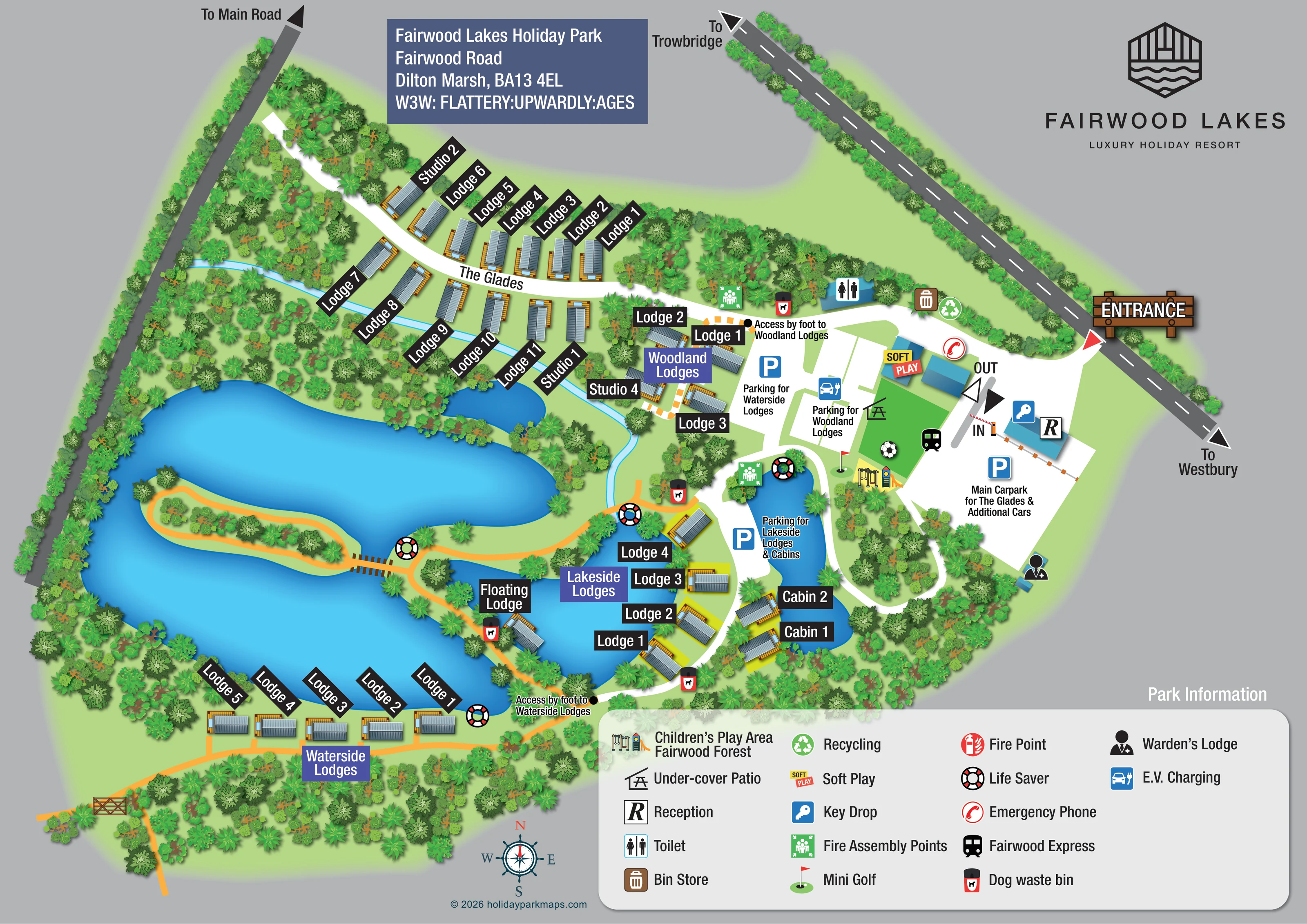
A large irregular lake dominates the western and southern grounds, with smaller connected-looking waters beside the Lakeside Lodges and cabins.
ILLUSTRATED PARK MAP · P115
Fairwood Lakes Holiday Park, Fairwood Road, Dilton Marsh · United Kingdom
 Enlarge the map ↗
A SENSE OF THE PLACE
Fairwood Lakes Holiday Park offers lodge accommodation at Dilton Marsh in Wiltshire. Lakeside, waterside, woodland and glade settings provide different styles of stay.
Selected lodges include private hot tubs and pet-friendly options. Some woodland properties have been created from converted shipping containers, with decking overlooking the lake. The map helps visitors understand these accommodation areas and their position within the grounds.
LOOK CLOSER
A large irregular lake dominates the western and southern grounds, with smaller connected-looking waters beside the Lakeside Lodges and cabins.
Dense illustrated tree cover surrounds the accommodation, follows the boundaries and separates the visitor facilities from the lake edges.
A thin pale-blue watercourse runs below The Glades and curves towards the central lakeside area.
Reception is marked on the blue building beside the entrance, vehicle barrier and main car park.
A blue key symbol identifies the key drop at reception.
A boldly coloured Soft Play label marks a building in the central visitor-facility cluster.
A roof-and-picnic-table symbol marks the covered patio beside the soft-play area.
Illustrated play equipment appears at the southern end of the recreation lawn. The legend names this feature ‘Children’s Play Area Fairwood Forest’.
Reception is marked on the blue building beside the entrance, vehicle barrier and main car park.
A blue key symbol identifies the key drop at reception.
A boldly coloured Soft Play label marks a building in the central visitor-facility cluster.
A roof-and-picnic-table symbol marks the covered patio beside the soft-play area.
Illustrated play equipment appears at the southern end of the recreation lawn. The legend names this feature ‘Children’s Play Area Fairwood Forest’.
A red flag and putting-green symbol locate mini golf beside the central recreation area.
A train pictogram marks the named Fairwood Express near the play area; no track or operating details are shown.
A toilet symbol marks a small building along the internal route north of the central facilities.
Adjacent bin-store and recycling symbols appear on the internal route towards the entrance.
Repeated red-and-black dog-bin symbols are placed around the woodland and waterside paths.
An electric-car symbol marks charging provision by the parking area for Woodland Lodges.
The warden’s lodge is identified at the lower edge of the main car park.
A red telephone symbol appears near the soft-play buildings and entrance circulation.
Green assembly-point symbols appear near the Woodland Lodges and beside the central waterbody.
Lifebuoy symbols are distributed around the lake shores, island bridge and lodge areas.
A fire-point symbol is explained in the legend, but a corresponding plotted location is not clearly identifiable.
A large irregular lake dominates the western and southern grounds, with smaller connected-looking waters beside the Lakeside Lodges and cabins.
Dense illustrated tree cover surrounds the accommodation, follows the boundaries and separates the visitor facilities from the lake edges.
An orange loop path circles a long planted island, reached by a short illustrated timber footbridge.
A thin pale-blue watercourse runs below The Glades and curves towards the central lakeside area.
A timber-style entrance sign, road arrow, IN and OUT labels and a barrier establish the arrival route beside reception.
Labels distinguish the main car park for The Glades and additional cars from parking for Waterside Lodges, Woodland Lodges, and Lakeside Lodges and cabins.
Explicit foot-access labels identify approaches to Woodland Lodges and Waterside Lodges, supported by orange paths and black location dots.
Road arrows point towards Trowbridge, Westbury and the main road. The southern orange path reaches a drawn gate and continues beyond the depicted grounds.
READING THE MAP
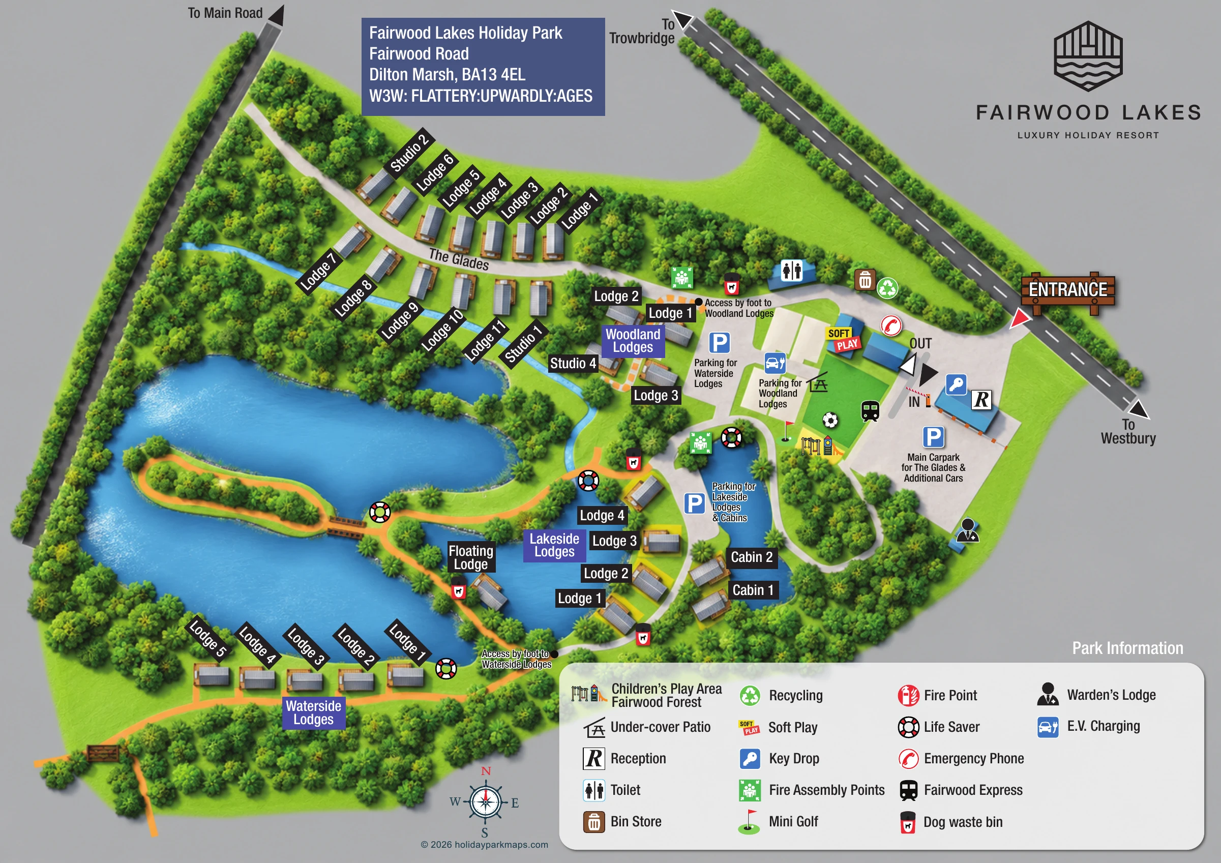
This illustrated map of Fairwood Lakes Holiday Park in Dilton Marsh, Wiltshire, makes the park’s lakes and woodland the main organising features. Rather than presenting accommodation as a uniform grid, it shows four distinct settings: The Glades, Woodland Lodges, Lakeside Lodges and Waterside Lodges. A separately labelled Floating Lodge, small cabins and studio accommodation add further character to the plan.
The arrival area sits beside the road towards Trowbridge and Westbury, with reception, the main car park and clearly marked entrance circulation grouped together. From there, visitors can identify the parking area for their accommodation and the routes leading onwards on foot. Orange paths trace the lake edges and cross a timber footbridge to a planted island, while white routes connect the main buildings and parking areas.
The map also brings together the park’s family facilities, including soft play, children’s play equipment, mini golf and the Fairwood Express. Detailed trees, shaded blue water and timber-effect lodge decking give the artwork a recognisable waterside identity, supported by strong accommodation labels and a substantial illustrated key.
The single landscape map places the entrance and reception on the right, reached from a diagonal road labelled towards Trowbridge and Westbury. IN and OUT arrows, a drawn barrier and a timber-style entrance sign make this arrival sequence prominent. The main car park is labelled for The Glades and additional cars, with further parking destinations identified for Woodland, Waterside and Lakeside accommodation.
The Glades extends across the upper-left grounds as two rows of lodges and studios along a curved white route. A narrow blue watercourse passes below this area through the woodland. Woodland Lodges forms a smaller cluster close to the central parking spaces, with a specific foot-access note. Farther south, Lakeside Lodges follows the edge of a smaller lake, and two cabins sit beside the narrow waterbody to its east. Waterside Lodges lines the southern shore of the large lake, reached by the orange pedestrian network. The Floating Lodge has its own prominent label beside the lakeside walk.
A long planted island sits within the large western lake. Its loop path and short timber footbridge provide a distinctive landmark. Dense tree illustration follows the shores and boundaries, separating the accommodation groups while leaving routes visible.
The central facility cluster includes soft play, the under-cover patio, children’s play equipment, mini golf and the Fairwood Express symbol. Toilets, waste and recycling, electric-vehicle charging, the key drop and warden’s lodge are also marked. Safety information includes assembly points, an emergency phone and lifebuoys around the water. The lower-right Park Information key explains the symbols, including a fire-point entry. Blue-purple area headings and angled black accommodation labels provide a clear hierarchy across the detailed landscape.
 Enlarge this map ↗
KEEP EXPLORING
Chosen for shared landscapes, accommodation or facilities.
 Explore the map ↗
United Kingdom
Woodland camping, lodges, lakes and colour-coded bike trails at Avon Tyrrell Outdoor Centre.
 Explore the map ↗
United Kingdom
Woodland park map with mixed pitches, bell tents, lodges and a fishing lake.
 Explore the map ↗
United Kingdom
Illustrated lakeside park plan with numbered holiday units, leisure buildings and a looping Woodland Walk.
Features may come from the sample artwork, its key or published park information. Approximate numbers describe the drawing and may cover only part of a park. They are intended to help you compare map examples. Current facilities and booking information should be checked with the park.
LET’S MAP YOUR PARK
For a map quotation, find your park and draw a rough boundary around it. The area you select helps us work out the design time and price.
Draw your park for a quote ↗Or talk to our map designers
01751 473136