
River Wey
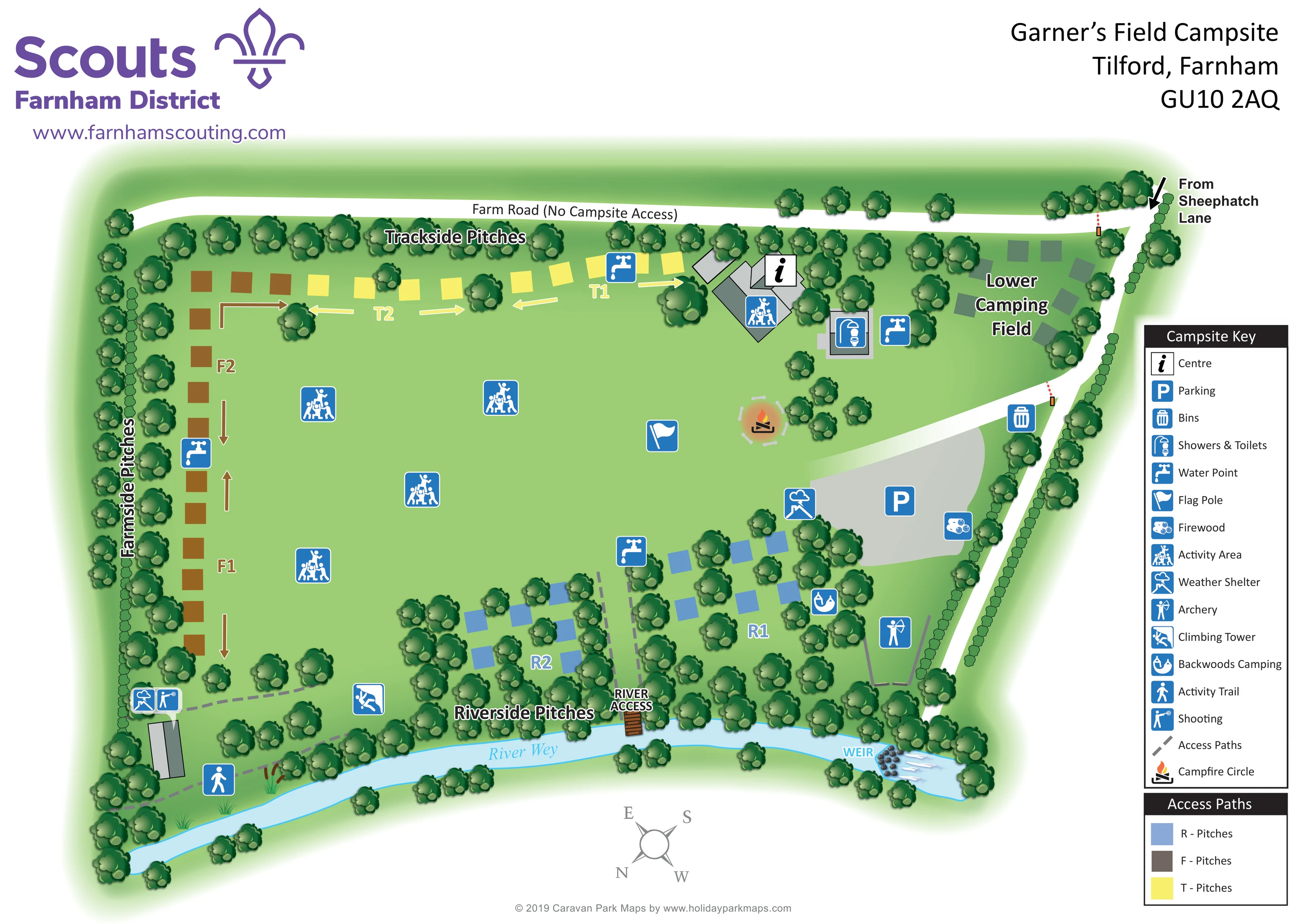
The named River Wey curves along the lower boundary of the campsite, beside the wooded Riverside Pitches.
ILLUSTRATED PARK MAP · P468
Garner’s Field Campsite, Tilford, Farnham · United Kingdom
 Enlarge the map ↗
A SENSE OF THE PLACE
Garner's Field is a youth campsite beside the River Wey at Tilford near Farnham. A mainly level camping field provides space for recognised youth organisations to gather and stay outdoors.
Activities include archery, climbing and abseiling, with river access for canoes and rafts. Shelters, drinking-water points and toilets and showers support group stays; visiting groups arrange their own activity instructors.
LOOK CLOSER
The named River Wey curves along the lower boundary of the campsite, beside the wooded Riverside Pitches.
A labelled weir is illustrated with rocks and white water at the lower-right end of the river.
Dense tree belts frame the camping field and surround the riverside sectors; clipped hedge symbols follow parts of the outer access boundaries.
An information-style symbol identifies the Centre within a cluster of grey-roofed buildings beside the Trackside Pitches and Lower Camping Field.
A broad grey parking area lies inside the right-hand entrance route, between the open field and wooded riverside pitches.
A combined showers and toilets symbol marks a separate rectangular building close to the Centre and Lower Camping Field.
Repeated tap symbols identify water points serving the trackside, farmside, riverside and Centre-side areas.
A bin symbol is placed beside the internal entrance branch near the parking area.
An information-style symbol identifies the Centre within a cluster of grey-roofed buildings beside the Trackside Pitches and Lower Camping Field.
A broad grey parking area lies inside the right-hand entrance route, between the open field and wooded riverside pitches.
A combined showers and toilets symbol marks a separate rectangular building close to the Centre and Lower Camping Field.
Repeated tap symbols identify water points serving the trackside, farmside, riverside and Centre-side areas.
A bin symbol is placed beside the internal entrance branch near the parking area.
A flag symbol marks a gathering landmark in the open central field, close to the campfire circle.
A log symbol identifies a firewood point at the right-hand edge of the parking area.
Repeated group-activity symbols are spread across the central grass field, with another at the Centre building cluster.
Weather-shelter symbols appear beside the parking area and at the lower-left activity building near the shooting area.
An archery symbol sits within a narrow outlined area between the wooded riverside pitches and the right-hand access road.
A climbing symbol locates the tower near the lower edge of the main field, between the lower-left activity area and Riverside Pitches.
A shooting symbol marks an activity location beside the lower-left shelter and building.
A flame-and-logs illustration with a pale segmented circular surround marks the campfire gathering space near the parking approach.
The named River Wey curves along the lower boundary of the campsite, beside the wooded Riverside Pitches.
A labelled weir is illustrated with rocks and white water at the lower-right end of the river.
Dense tree belts frame the camping field and surround the riverside sectors; clipped hedge symbols follow parts of the outer access boundaries.
A dashed path between the two riverside sectors leads to a small timber landing labelled River Access.
A walking-person symbol identifies an activity trail along the wooded lower-left river margin.
Grey dashed paths connect lower-field activity locations and run towards the river landing through the riverside camping area.
A large arrow at the upper-right corner indicates arrival from Sheephatch Lane. The white route follows the right-hand boundary and branches towards parking.
The separate road across the top of the plan is explicitly labelled Farm Road (No Campsite Access), distinguishing it from the campsite approach.
READING THE MAP
This illustrated map of Garner’s Field Campsite at Tilford, near Farnham, presents a youth camping site shaped by its open field, wooded boundaries and the River Wey. Rather than depicting holiday homes or tightly numbered plots, it organises camping into clearly named Trackside, Farmside and Riverside sectors, alongside a Lower Camping Field and a backwoods camping area.
The broad central grass space remains visually open, with activity symbols, a flag pole and a campfire circle helping visitors recognise shared gathering areas. Around it, the map locates the Centre, showers and toilets, water points, parking and weather shelters. Archery, shooting, a climbing tower and an activity trail give the plan a distinctly outdoor-learning focus.
Purple Farnham District Scouts branding anchors the header, while a right-hand key explains the blue facility symbols. The river frontage adds both character and practical landmarks: a timber access point and an illustrated weir. This sample shows how a campsite map can combine group-camping organisation, activity locations and arrival information without relying on individual pitch numbers.
The plan is built around a large green field, with camping arranged mainly along its edges. Yellow markers identify the Trackside Pitches across the top, brown markers follow the Farmside boundary on the left, and blue markers form two wooded Riverside groups beside the River Wey. Letter-number labels and matching arrows distinguish sector subdivisions. A separate Lower Camping Field occupies the upper-right portion of the site, near the Centre and amenity building.
Arrival is indicated from Sheephatch Lane at the upper-right corner. The white access route follows the right boundary and branches towards a broad grey parking area. Across the top, a separate white road is explicitly labelled Farm Road (No Campsite Access), making the distinction between the two approaches prominent. Grey dashed paths link the lower activity areas and lead between the Riverside sectors to a small timber river landing.
Blue pictograms locate showers and toilets, repeated water points, bins, firewood, weather shelters and activity areas. The open field includes a flag pole and an illustrated campfire circle. More specialised activity locations sit around the margins: shooting and a shelter at lower left, a climbing tower near the riverside tree belt, and archery beside the right-hand route. Backwoods Camping is marked among the trees, while an activity-trail symbol appears along the lower-left river margin.
Shaded tree crowns give the boundaries texture without obscuring the central field. The river is drawn in pale blue with reeds, a labelled access point and a rock-and-white-water weir. A tall facility key and smaller pitch-colour panel sit to the right; Scout branding, address details and a rotated compass complete the single-page composition.
KEEP EXPLORING
Chosen for shared landscapes, accommodation or facilities.
 Explore the map ↗
United Kingdom
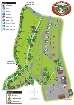
A stream-side farm campsite plan with car-free camping, caravan pitches and separate bell-tent areas.
 Explore the map ↗
United Kingdom
Woodland park map with mixed pitches, bell tents, lodges and a fishing lake.
 Explore the map ↗
United Kingdom
Woodland holiday homes, named camping fields and farm buildings on a colour-coded Nether Wasdale park map.
Features may come from the sample artwork, its key or published park information. Approximate numbers describe the drawing and may cover only part of a park. They are intended to help you compare map examples. Current facilities and booking information should be checked with the park.
TAKE A CLOSER LOOK
View the illustrated map in detail or choose a file to download. These are sample maps; contact the park for current visitor information.


LET’S MAP YOUR PARK
For a map quotation, find your park and draw a rough boundary around it. The area you select helps us work out the design time and price.
Draw your park for a quote ↗Or talk to our map designers
01751 473136