
Ponds and narrow watercourse
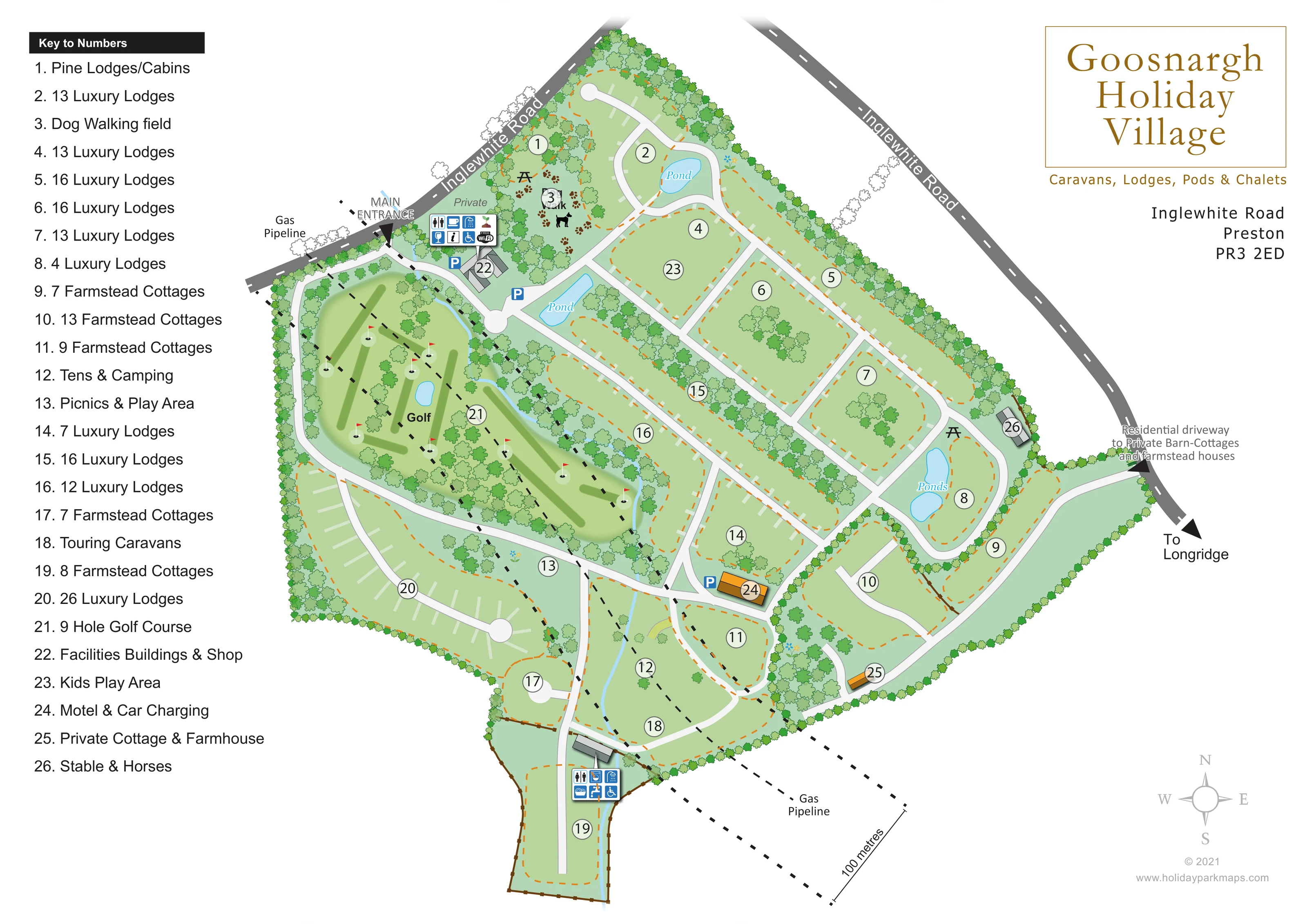
Blue ponds punctuate the northern, central and eastern areas, with a further pond in the golf course. A narrow blue watercourse continues towards the southern extension.
ILLUSTRATED PARK MAP · P476
Inglewhite Road, Preston · United Kingdom
 Enlarge the map ↗
A SENSE OF THE PLACE
Goosnargh Lodge Park is based at Inglewhite Road, Preston. The site is located in the Goosnargh countryside with walking routes and Ye Horns Inn nearby. Holiday lodges are sold for private ownership.
The lodges use large windows and natural materials to connect with the rural setting.
LOOK CLOSER
Blue ponds punctuate the northern, central and eastern areas, with a further pond in the golf course. A narrow blue watercourse continues towards the southern extension.
Dense tree symbols trace much of the perimeter and divide accommodation neighbourhoods, roads and recreational land.
Parallel black dashed lines cross the plan diagonally and are labelled Gas Pipeline, with a nearby 100 metres annotation.
A large golf area occupies the western side, illustrated with fairways, greens, flags, trees and a small pond.
A wooded field near the main entrance is marked with a dog silhouette, paw prints and a picnic-table symbol.
The key locates a children's play area within the northern accommodation layout and a picnic/play area south of the golf course.
The main facilities and shop building stands immediately inside the principal entrance.
Toilet and shower symbols appear in facility panels at the entrance building and the southern facilities block.
A large golf area occupies the western side, illustrated with fairways, greens, flags, trees and a small pond.
A wooded field near the main entrance is marked with a dog silhouette, paw prints and a picnic-table symbol.
The key locates a children's play area within the northern accommodation layout and a picnic/play area south of the golf course.
The main facilities and shop building stands immediately inside the principal entrance.
Toilet and shower symbols appear in facility panels at the entrance building and the southern facilities block.
Coffee-cup and wine-glass symbols are attached to the entrance facilities panel; these indicate refreshments without naming a specific café or bar.
Information and free Wi-Fi symbols are shown at the main facilities building.
Wheelchair symbols appear in both facility panels. They identify mapped provision but do not establish site-wide accessibility.
The southern block includes pictograms for laundry, washing-up and a water tap, alongside toilets and showers.
A distinctive orange-roofed building on the southern internal road is identified as a motel with car charging.
Blue P symbols identify parking near the entrance facilities, the central junction and the motel.
A small stable building is located near the eastern boundary beside the outer lodge road.
The plan distinguishes a private cottage and farmhouse within the eastern side and a separate driveway to private barn-cottages and farmstead houses.
Blue ponds punctuate the northern, central and eastern areas, with a further pond in the golf course. A narrow blue watercourse continues towards the southern extension.
Dense tree symbols trace much of the perimeter and divide accommodation neighbourhoods, roads and recreational land.
A bold arrow identifies the principal arrival point on the north-western side, immediately beside the facilities building.
White internal roads form connected loops, branching streets and rounded turning heads, with a long spur into the southern cottage area.
An external-road arrow at the eastern edge points towards Longridge.
Parallel black dashed lines cross the plan diagonally and are labelled Gas Pipeline, with a nearby 100 metres annotation.
READING THE MAP
This illustrated map presents Goosnargh Holiday Village on Inglewhite Road, Preston, as a landscaped collection of accommodation areas arranged around a substantial golf course. Rather than filling the page with individual lodge numbers, the design uses numbered neighbourhoods linked to a clear key. Luxury lodges, pine cabins, farmstead cottages, camping and touring areas can therefore be understood together with the site's recreational spaces and main facilities.
The overhead plan gives particular prominence to the rural character of the setting. Tree belts frame the boundary, ponds break up the accommodation layout, and the nine-hole golf course is drawn with fairways, greens and flags. White roads connect the different areas, while the main entrance, parking points and separate private residential driveway establish the arrival structure.
A large legend on the left and an ochre-framed title on the right give the page a practical, spacious composition. The sample is especially relevant to larger lodge or mixed-accommodation developments that need to explain distinct neighbourhoods, shared amenities and surrounding landscape without relying on a detailed pitch-by-pitch plan.
The single landscape-format artwork combines an overhead site plan with a 26-entry numbered key. Its irregular footprint runs diagonally between sections of Inglewhite Road, with a narrow extension projecting south. The main entrance sits at the north-western edge beside the facilities buildings and shop; blue parking symbols and an anchored pictogram panel reinforce this arrival point. A separate eastern driveway is labelled for private barn-cottages and farmstead houses, and an arrow on the adjoining road points towards Longridge.
The western half is dominated by a nine-hole golf course. Green fairway strokes, circular greens, red flags, trees and a small pond distinguish it from the accommodation land. To its north and east, connected road loops serve numbered lodge areas, several arranged around ponds or planted open spaces. The dog-walking field near the entrance uses paw prints and a dog silhouette, while a separate children's play area occupies a central northern green space.
Farmstead-cottage areas sit mainly along the eastern and southern roads. Camping and touring land is grouped below the golf course, near a second facilities block, with a further cottage area reached by the long southern spur. Other numbered destinations include a picnic/play area, a motel with car charging, a private cottage and farmhouse, and a stable.
Facility panels identify toilets, showers and wheelchair provision; the entrance panel also carries refreshment, information and Wi-Fi symbols, while the southern panel shows additional service pictograms. Orange dashed outlines separate many land-use areas. A labelled gas-pipeline overlay crosses the plan in black dashes. The enlarged detail repeats part of this same artwork, clarifying the key and entrance rather than showing a separate site or map variant.
KEEP EXPLORING
Chosen for shared landscapes, accommodation or facilities.
 Explore the map ↗
United Kingdom
A woodland estate park map combining caravan loops, touring pitches, riverside paths and Bruce’s Cave landmarks.
 Explore the map ↗
United Kingdom
Woodland-framed Barnsoul map with mixed accommodation, shared facilities and paw-marked walking routes.
 Explore the map ↗
United Kingdom
Illustrated farm campsite map with touring pitches, pods, camping fields and a riverside dog-walk route.
Features may come from the sample artwork, its key or published park information. Approximate numbers describe the drawing and may cover only part of a park. They are intended to help you compare map examples. Current facilities and booking information should be checked with the park.
TAKE A CLOSER LOOK
View the illustrated map in detail or choose a file to download. These are sample maps; contact the park for current visitor information.


LET’S MAP YOUR PARK
For a map quotation, find your park and draw a rough boundary around it. The area you select helps us work out the design time and price.
Draw your park for a quote ↗Or talk to our map designers
01751 473136