
Horseshoe Lake, Carp Lake and Lakeside waters
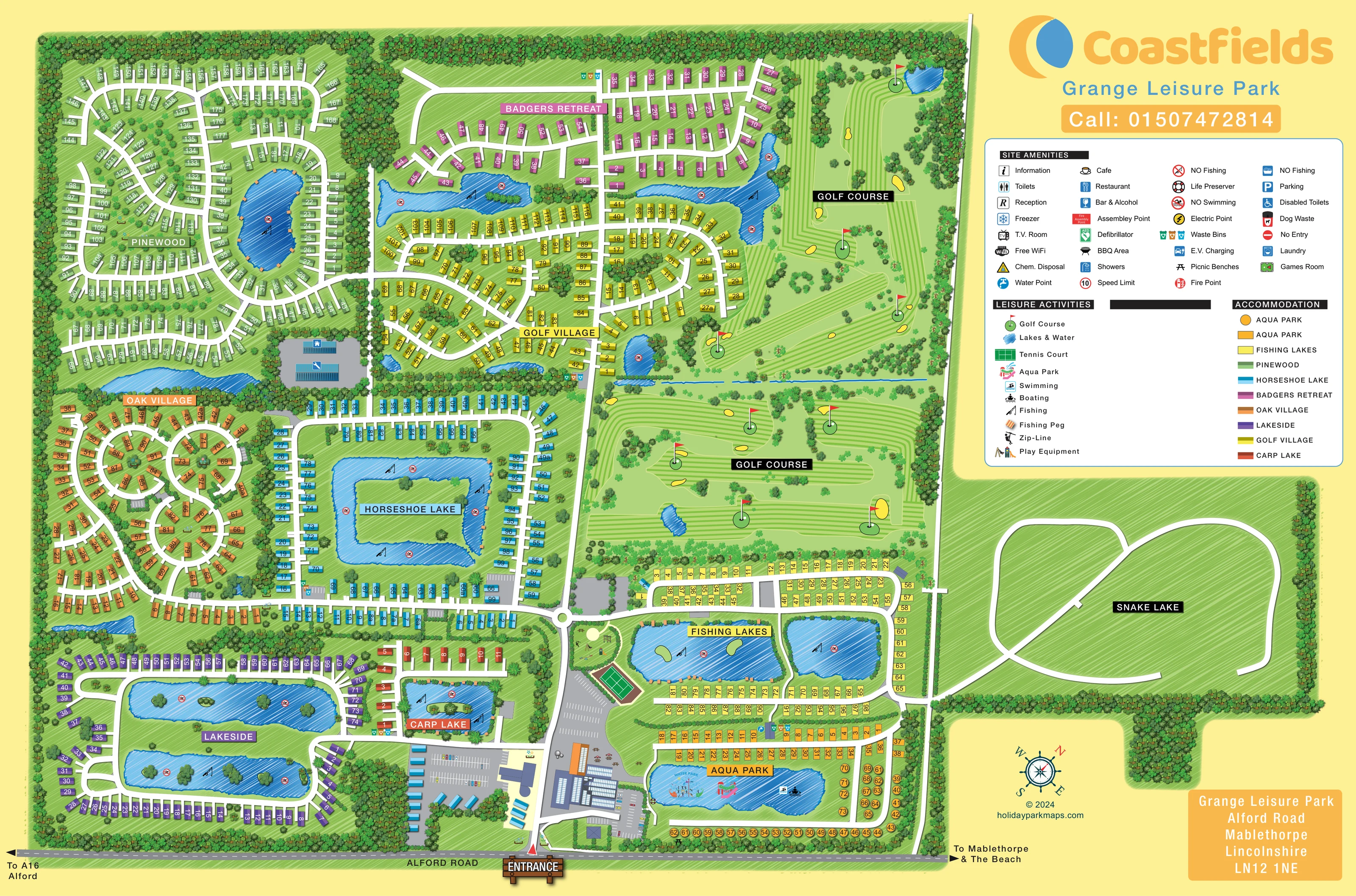
Distinctive water shapes organise several accommodation neighbourhoods, including a squared horseshoe-shaped lake, a compact Carp Lake with an island and two elongated Lakeside waters.
ILLUSTRATED PARK MAP · P140
Grange Leisure Park, Alford Road, Mablethorpe, Lincolnshire · United Kingdom
 Enlarge the map ↗
A SENSE OF THE PLACE
Grange Leisure Park combines holiday accommodation and ownership with outdoor leisure near Mablethorpe. Its countryside grounds include fishing lakes, a short golf course and the Lincolnshire Aqua Park.
A children's play area, arcade and seasonal entertainment provide further activities. Food and drink facilities support time on site, while Mablethorpe and the Lincolnshire coast are nearby destinations for beach days and seaside outings.
LOOK CLOSER
Distinctive water shapes organise several accommodation neighbourhoods, including a squared horseshoe-shaped lake, a compact Carp Lake with an island and two elongated Lakeside waters.
Dense tree rows frame the boundary and divide neighbourhoods, while shrubs, planted courts and wooded lake islands soften the accommodation layout.
A separate eastern extension is labelled Snake Lake and contains white looping routes on green ground. It is not rendered as blue water and contains no numbered accommodation markers.
Fishing-rod symbols appear on numerous lakes, with small striped peg markers along selected banks. A separate Fishing Lakes section contains two prominent ponds.
A substantial course fills the upper-right and central-right grounds, illustrated with striped fairways, flag-marked greens, yellow bunkers, trees and small water hazards.
The lower-right lake includes a colourful inflatable water-play illustration and an Aqua Park label.
Swimming and boating pictograms are placed on the Aqua Park water, distinguishing it from lakes carrying no-swimming symbols.
A green court with white line markings lies beside the main arrival route, between the play area and entrance-side parking.
Fishing-rod symbols appear on numerous lakes, with small striped peg markers along selected banks. A separate Fishing Lakes section contains two prominent ponds.
Distinctive water shapes organise several accommodation neighbourhoods, including a squared horseshoe-shaped lake, a compact Carp Lake with an island and two elongated Lakeside waters.
A substantial course fills the upper-right and central-right grounds, illustrated with striped fairways, flag-marked greens, yellow bunkers, trees and small water hazards.
The lower-right lake includes a colourful inflatable water-play illustration and an Aqua Park label.
Swimming and boating pictograms are placed on the Aqua Park water, distinguishing it from lakes carrying no-swimming symbols.
A green court with white line markings lies beside the main arrival route, between the play area and entrance-side parking.
An enclosed green play space near the central roundabout shows several items of play equipment and a zip-line symbol.
Large illustrated buildings, paved forecourts and parking occupy both sides of the entrance road. The individual functions of every building are not labelled directly.
Large marked parking areas flank the entrance complex, with smaller parking bays distributed among accommodation areas.
Bench illustrations sit near the entrance-side buildings and in nearby green space.
Blue water-point symbols and grouped coloured waste-bin symbols appear beside roads and service spaces in several accommodation sections.
Repeated no-swimming symbols mark fishing waters, and life-preserver symbols appear beside the Aqua Park lake.
Reception and information symbols are included in the amenities key; their precise positions are not confidently resolved in these views.
The key lists café, restaurant and bar symbols. These entries alone do not establish the function of a particular illustrated building.
The amenities legend includes these washroom and laundry categories without guaranteeing accessibility or current availability.
These indoor and service amenities are represented in the key, but their individual locations are not clearly identified in the map views.
Electric-point and chemical-disposal symbols appear in the site amenities legend.
These facilities have legend entries; no positive location claim is made from the key alone.
The legend includes fire points, an assembly point, a defibrillator, a speed-limit symbol, no-entry and no-fishing symbols.
Dense tree rows frame the boundary and divide neighbourhoods, while shrubs, planted courts and wooded lake islands soften the accommodation layout.
A separate eastern extension is labelled Snake Lake and contains white looping routes on green ground. It is not rendered as blue water and contains no numbered accommodation markers.
A prominent entrance sign anchors the main access from Alford Road along the bottom of the plan.
Road-edge arrows point towards the A16 and Alford in one direction, and Mablethorpe and the beach in the other; the beach itself is not depicted.
A main entrance spine reaches a small roundabout before branching into accommodation loops, lakeside roads and the eastern leisure grounds.
READING THE MAP
This illustrated map of Grange Leisure Park brings a large countryside holiday site near Mablethorpe into one coordinated visitor plan. Accommodation villages, fishing waters, a golf course and an Aqua Park share the page, with colour doing much of the work of separating the different neighbourhoods. Pinewood, Badgers Retreat, Oak Village, Golf Village and the lakeside areas each have their own visual identity, while white roads connect them to the entrance on Alford Road.
The landscape is central to the design rather than simply a backdrop. Blue lakes form recognisable landmarks between rows of accommodation, tree belts divide the grounds, and striped golf fairways occupy a substantial part of the eastern side. Near the entrance, larger buildings, parking, a tennis court and a play area provide another useful cluster of reference points.
A prominent Coastfields heading and a large grouped legend balance the densely illustrated plan. This sample is particularly relevant to parks that need to explain several named accommodation areas alongside extensive outdoor leisure facilities, without losing the practical detail of numbered units and internal routes.
The plan begins at a timber-style entrance sign on Alford Road, with arrows towards Alford and the A16 on one side and Mablethorpe and the beach on the other. The main access road passes between building complexes and parking areas before reaching a small roundabout. From here, broad white routes branch towards the accommodation villages and leisure grounds.
Pinewood fills much of the upper-left corner with green numbered units arranged around curving roads and a fishing lake. Pink Badgers Retreat sits above yellow Golf Village, separated in places by narrow waters and planted margins. Orange Oak Village uses a series of circular courts, while cyan accommodation encloses the distinctive Horseshoe Lake. Purple Lakeside units follow two long lakes in the lower-left grounds, and a smaller rust-coloured group borders Carp Lake.
The right side introduces a different rhythm. Golf fairways, greens, bunkers and water hazards occupy a broad landscape above two fishing ponds. A tennis court and an enclosed play area with equipment and a zip-line sit close to the arrival route. Below the fishing section, the Aqua Park lake contains a colourful inflatable-play illustration and swimming and boating symbols. Its surrounding numbered markers include both rectangles and circles. Repeated bin and water-point symbols provide smaller service landmarks.
A separate eastern area labelled Snake Lake is drawn with white looping routes on green ground, rather than blue water or numbered units. Above it, the large legend explains amenities, activities and area colours. Coastfields branding, a compass and an address panel complete the composition. The enlarged views reveal details of this same single artwork; there is no separate inset or alternate map variant.
KEEP EXPLORING
Chosen for shared landscapes, accommodation or facilities.
 Explore the map ↗
United Kingdom
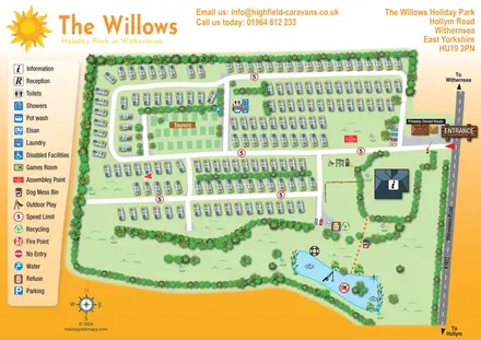
An overhead caravan and touring park map with sun branding, a pictogram key and an illustrated fishing lake.
 Explore the map ↗
United Kingdom
Illustrated lakeside park plan with numbered holiday units, leisure buildings and a looping Woodland Walk.
 Explore the map ↗
United Kingdom
Illustrated caravan park plan with woodland and riverside walks, fishing pools and wildlife panels.
Features may come from the sample artwork, its key or published park information. Approximate numbers describe the drawing and may cover only part of a park. They are intended to help you compare map examples. Current facilities and booking information should be checked with the park.
LET’S MAP YOUR PARK
For a map quotation, find your park and draw a rough boundary around it. The area you select helps us work out the design time and price.
Draw your park for a quote ↗Or talk to our map designers
01751 473136