
Top fishing lake
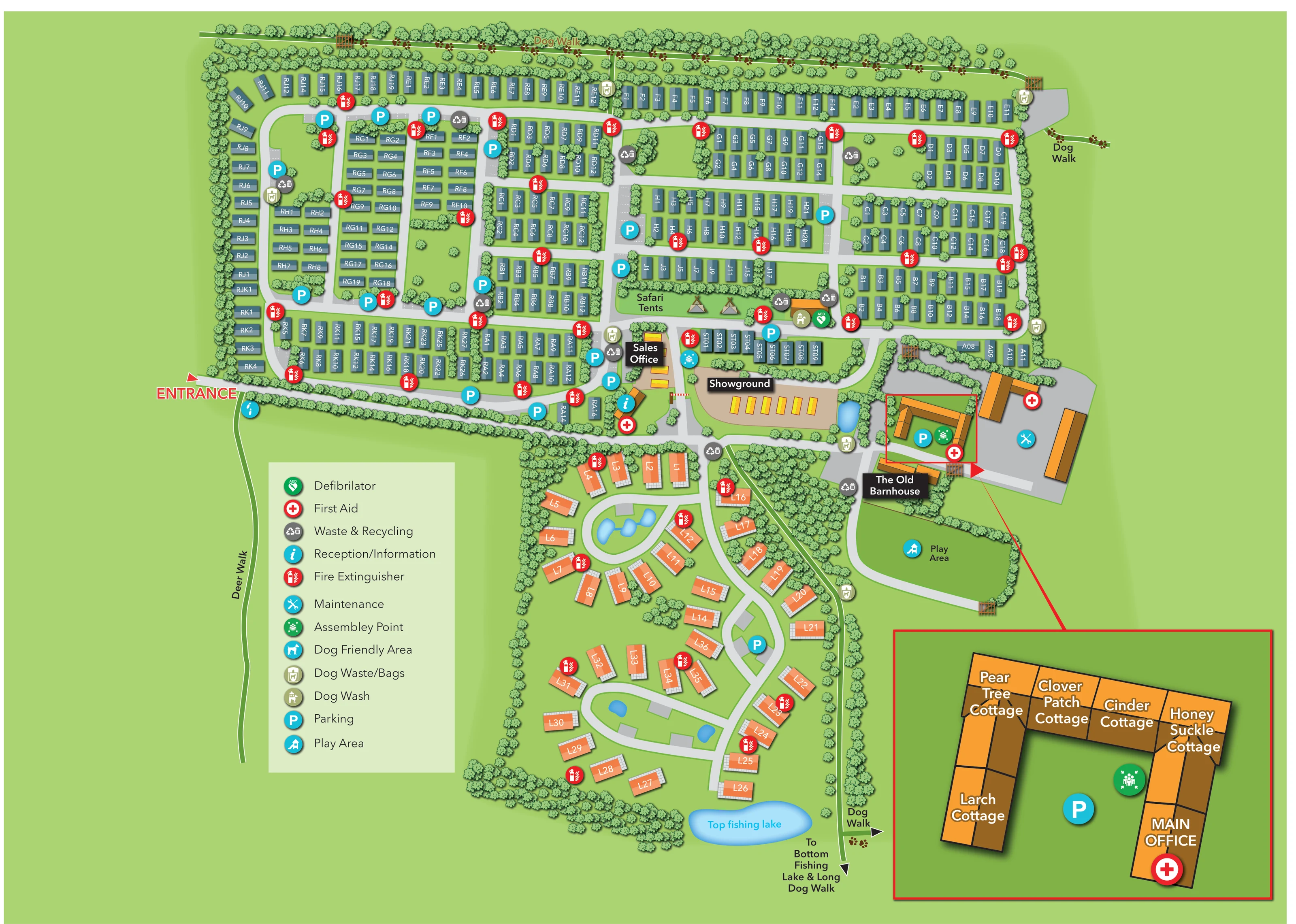
A blue lake is drawn at the southern end of the lodge area and explicitly labelled Top fishing lake.
ILLUSTRATED PARK MAP · P536
Worcester, Herefordshire · United Kingdom
 Enlarge the map ↗
A SENSE OF THE PLACE
Malvern View Holiday Park is based at Worcester, Herefordshire. The farmland setting lies on the Herefordshire and Worcestershire border and includes walking trails and a red-deer reserve. The park markets caravan holidays.
Bar/restaurant includes a dog-friendly area and venue Wi-Fi. The park lists fishing lakes, heated indoor pool, children's play area, laundry, gym and steam room.
LOOK CLOSER
A blue lake is drawn at the southern end of the lodge area and explicitly labelled Top fishing lake.
Several small blue ponds occupy the lodge-road islands, with another water feature beside the showground.
Dense illustrated trees enclose the accommodation areas, divide selected rows and form a substantial planted buffer beside the southern lodges.
A red arrow and prominent ENTRANCE label mark the western end of the main approach road.
Turquoise information symbols appear at the entrance and beside the central arrival and sales area.
A labelled sales office stands beside a tan showground containing yellow-orange display units.
The enlarged courtyard plan locates the main office in the right-hand wing of the cottage complex.
A named building beside the courtyard complex forms a landmark between the sales area and the play area.
A red arrow and prominent ENTRANCE label mark the western end of the main approach road.
Turquoise information symbols appear at the entrance and beside the central arrival and sales area.
A labelled sales office stands beside a tan showground containing yellow-orange display units.
The enlarged courtyard plan locates the main office in the right-hand wing of the cottage complex.
A named building beside the courtyard complex forms a landmark between the sales area and the play area.
A large green enclosure south of the building complex is labelled Play Area and marked with a turquoise play symbol.
Turquoise P symbols mark distributed parking within the accommodation blocks, near the sales office, in the lodge area and in the cottage courtyard.
Grey circular bin and recycling symbols are distributed along internal roads and around the central buildings.
Repeated red extinguisher symbols mark locations throughout the caravan and lodge areas.
Red-and-white cross symbols appear around the arrival and building areas, including the main office in the inset.
A green AED symbol is shown beside the small building near the Safari Tents strip.
Green assembly symbols appear beside the showground and within the cottage courtyard.
A turquoise crossed-tools symbol marks the hardstanding and buildings east of the cottage courtyard.
A turquoise dog symbol marks an area beside the showground; it does not define a park-wide pet policy.
An olive dog-wash symbol is positioned near the Safari Tents strip and AED point.
Olive dog-waste symbols appear around the perimeter walking routes and near central facilities.
A paw-print route follows the northern boundary, with another route running down the eastern side and arrows indicating onward walks.
A narrow, white-edged route labelled Deer Walk extends south from the entrance outside the accommodation boundary.
A blue lake is drawn at the southern end of the lodge area and explicitly labelled Top fishing lake.
A downward arrow at the southern edge points to the Bottom Fishing Lake & Long Dog Walk beyond the drawn plan.
Several small blue ponds occupy the lodge-road islands, with another water feature beside the showground.
Dense illustrated trees enclose the accommodation areas, divide selected rows and form a substantial planted buffer beside the southern lodges.
READING THE MAP
This illustrated map of Malvern View Holiday Park brings together a substantial holiday-home layout and the quieter landscape features that give the site its country-park character. Set in the Herefordshire and Worcestershire border countryside, the park is represented through tree-lined accommodation rows, a separate southern lodge area, fishing water and clearly marked walking routes.
The artwork uses an overhead plan rather than a scenic aerial view. Blue-grey caravan-style homes form compact blocks across the upper half, while orange-roofed lodges follow curving roads around small ponds below. Between them, the sales office, showground and Old Barnhouse provide recognisable landmarks. A large courtyard inset makes the named cottages and main office easier to find without crowding the main plan.
Practical visitor information is carried by bright circular symbols for parking, information, dog-care points, play space and safety equipment. The northern paw-print dog walk and the separate Deer Walk also make outdoor routes part of the map's main story. It is a useful sample for a large rural park needing accommodation-level wayfinding alongside leisure routes and a detailed building cluster.
The main entrance is marked by a red arrow on the western side of the plan. From here, a broad grey road runs along the lower edge of the principal caravan area towards the information point, sales office and showground. Branching roads divide the upper accommodation into compact rows and paired blocks, with white letter-and-number identifiers placed directly on the blue-grey units. Parking, waste and recycling, and fire extinguisher symbols are distributed throughout this network.
The southern accommodation has a different visual rhythm. Larger orange-roofed lodge-style units, many with pale gridded decking, turn around curved roads and green islands containing small blue ponds. Dense tree planting separates parts of this area from the central buildings. The labelled Top fishing lake sits at its southern end, while arrows point beyond the plan towards the bottom fishing lake and long dog walk.
Near the centre, a labelled Safari Tents strip sits above the sales and showground area. Nearby symbols identify a dog wash and defibrillator. Further east, the Old Barnhouse, cottage courtyard and maintenance buildings form a distinct cluster, with a substantial play area immediately below. A red outline and leader connect the courtyard to a lower-right enlargement naming five cottages and the main office, alongside parking, first aid and an assembly point.
Walking routes remain visually separate from vehicle roads. Paw prints follow the northern dog walk, an eastern path continues south, and the Deer Walk extends below the entrance. A twelve-symbol legend occupies the lower-left corner. This is one complete map artwork: the enlarged views show overlapping details of the same plan, while the courtyard inset clarifies an existing building group rather than adding another accommodation area.
KEEP EXPLORING
Chosen for shared landscapes, accommodation or facilities.
 Explore the map ↗
United Kingdom
Woodland park map with mixed pitches, bell tents, lodges and a fishing lake.
 Explore the map ↗
United Kingdom
Colour-coded accommodation, lakeside facilities and woodland routes at Burton Constable Holiday Park & Arboretum.
 Explore the map ↗
United Kingdom
Illustrated caravan park plan with woodland and riverside walks, fishing pools and wildlife panels.
Features may come from the sample artwork, its key or published park information. Approximate numbers describe the drawing and may cover only part of a park. They are intended to help you compare map examples. Current facilities and booking information should be checked with the park.
LET’S MAP YOUR PARK
For a map quotation, find your park and draw a rough boundary around it. The area you select helps us work out the design time and price.
Draw your park for a quote ↗Or talk to our map designers
01751 473136