
River Idle
A broad pale-blue river follows the park's long upper and left-hand boundary, bending around the western pitch areas.
ILLUSTRATED PARK MAP · P156
Haxey Quays Caravan and Camping, Haxey Road, Misterton, Doncaster · United Kingdom
 Enlarge the map ↗
A SENSE OF THE PLACE
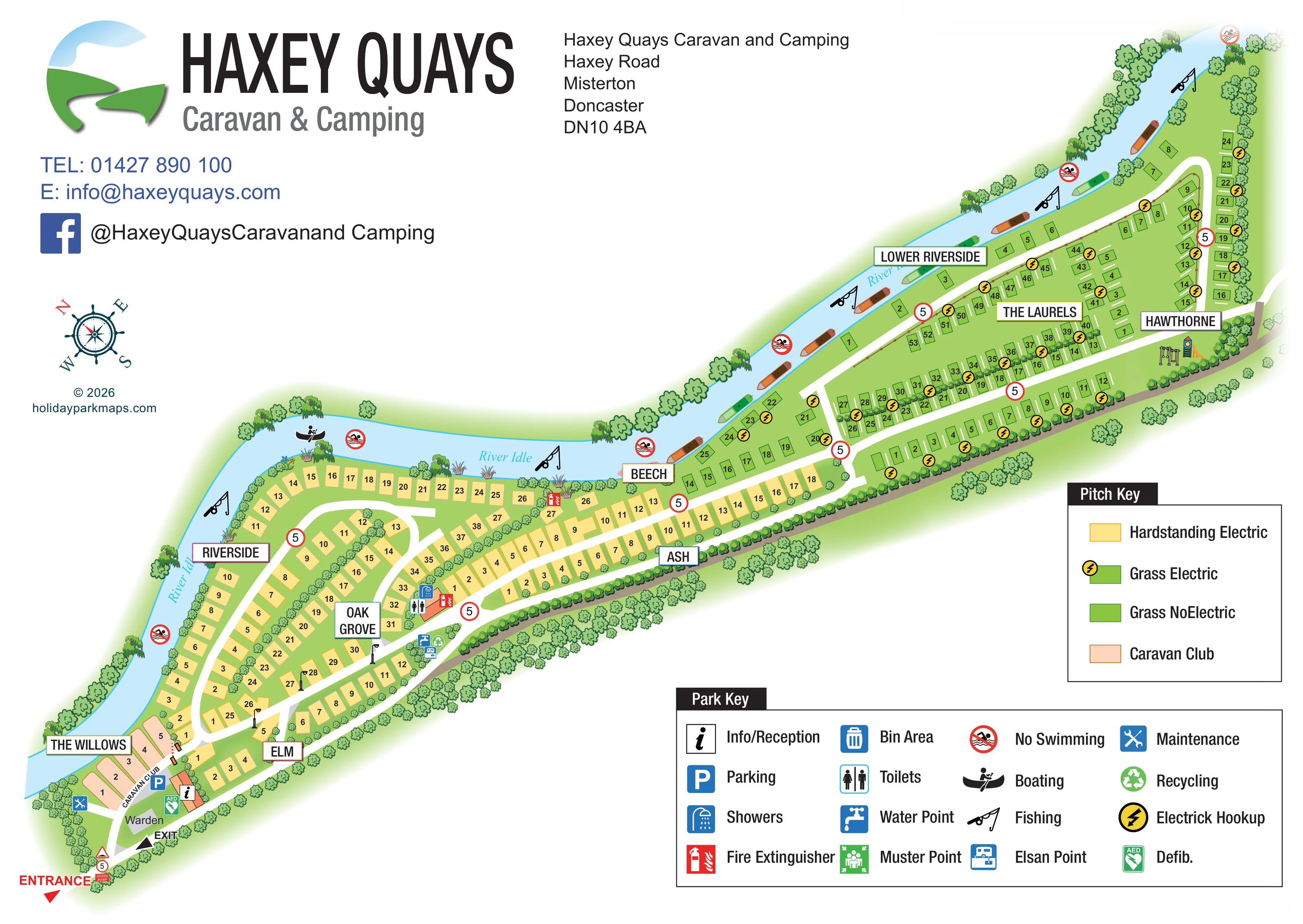
Haxey Quays Caravan and Camping is located on Haxey Road near Misterton and Doncaster. The site's visitor information provides direct contact arrangements for planning a camping or caravan stay.
The park map gives an overview of the grounds, pitch layout and access routes. It provides a useful starting point for understanding the site before exploring the surrounding area.
LOOK CLOSER
A broad pale-blue river follows the park's long upper and left-hand boundary, bending around the western pitch areas.
Illustrated trees and shrubs line the river, outer boundary and several internal pitch divisions, with reeds and willow-like trees along the water.
Separate labelled entrance and exit arrows appear at the lower-left end of the site, beside the arrival facilities.
White roads form loops through the broader western section and long connecting branches through the narrow eastern section.
Circular 5 markers recur along the roads; a speed-bump sign and symbol appear at the entrance.
The information symbol marks a small orange-roofed building beside the arrival road.
A grey footprint labelled Warden sits near reception, parking and the exit.
A blue parking symbol is positioned beside the Caravan Club pitches near reception.
A broad pale-blue river follows the park's long upper and left-hand boundary, bending around the western pitch areas.
Illustrated trees and shrubs line the river, outer boundary and several internal pitch divisions, with reeds and willow-like trees along the water.
Separate labelled entrance and exit arrows appear at the lower-left end of the site, beside the arrival facilities.
White roads form loops through the broader western section and long connecting branches through the narrow eastern section.
Circular 5 markers recur along the roads; a speed-bump sign and symbol appear at the entrance.
The information symbol marks a small orange-roofed building beside the arrival road.
A grey footprint labelled Warden sits near reception, parking and the exit.
A blue parking symbol is positioned beside the Caravan Club pitches near reception.
Toilet and shower symbols identify a central service building near Oak Grove and the connecting road.
A water-point symbol appears in the service cluster beside the main road near Oak Grove.
An Elsan disposal symbol is included in the central roadside service cluster.
Bin and recycling symbols are grouped with the water and Elsan facilities near Oak Grove.
Yellow lightning symbols mark electric provision among the green grass pitches; the pitch key also identifies electric hardstanding.
Red fire-extinguisher symbols appear at several locations, including near the arrival pitches, central facilities and river-facing pitches.
A green AED symbol is placed beside reception near the entrance.
A maintenance symbol marks a small area on the western side of the arrival cluster.
Fishing-rod symbols occur at intervals along the River Idle.
A paddling symbol and several illustrated boats give the river a boating emphasis.
Red no-swimming symbols repeat along the river edge.
A small illustrated swing and slide grouping sits near Hawthorne at the far eastern end.
A muster-point symbol is explained in the Park Key, but a corresponding position is not clearly identifiable on the plan.
READING THE MAP
This map of Haxey Quays Caravan and Camping near Misterton, Doncaster, is organised around the River Idle and the park’s unusually long riverside footprint. The grounds sweep diagonally across the page, widening into curved pitch rows at one end and narrowing into extended grass-pitch sections at the other. Trees, reeds, boats and fishing symbols give the river a clear visual role rather than treating it as a simple boundary line.
The map combines numbered pitches with named areas such as Riverside, Oak Grove, The Laurels and Hawthorne. A separate pitch key distinguishes electric hardstanding, electric grass, non-electric grass and Caravan Club pitches, while the larger Park Key explains visitor facilities and safety symbols. Reception, parking and the warden are grouped near the entrance, with the central service facilities and eastern play equipment shown elsewhere along the site. Large branding and contact details occupy the open space above the plan, creating a practical visitor map with a strong park identity.
The plan begins at the lower-left entrance, where a speed-bump marker, separate exit arrow and compact arrival cluster establish the starting point for navigation. Reception is shown as a small orange-roofed building beside parking and the warden’s footprint. The peach-coloured Caravan Club pitches sit nearby in The Willows, while yellow hardstanding pitches extend into Elm, Riverside and Oak Grove.
White roads curve through the broader western grounds, linking river-facing pitches with internal rows. The central toilet and shower building is marked near Oak Grove, alongside fire-safety symbols. A nearby roadside cluster identifies water, bins, recycling and Elsan disposal. Farther along, Ash and Beech lead into the green-pitch sections of Lower Riverside, The Laurels and Hawthorne. These eastern areas use longer rows and branching roads, with yellow lightning symbols making electric provision visible. A small illustration of play equipment appears near the far end.
The River Idle follows the park’s upper edge and curves down its western side. Its pale-blue water contains illustrated boats, while fishing symbols and repeated no-swimming markers sit along the bank. Trees and shrubs frame the site and divide selected pitch rows, helping the reader distinguish individual sections within the continuous strip of grounds.
The page has two complementary legends: one for pitch categories and another for facilities and safety information. Boxed section labels, pitch numbers, repeated circular speed markers and a compass complete the wayfinding system. The artwork is a single whole-site plan; the enlarged views show details of that same page rather than additional park sections.
KEEP EXPLORING
Chosen for shared landscapes, accommodation or facilities.
 Explore the map ↗
United Kingdom
Colour-coded campsite map with riverside pitches, bell tents, a swimming pool and fishing lake.
 Explore the map ↗
United Kingdom
Woodland park map with mixed pitches, bell tents, lodges and a fishing lake.
 Explore the map ↗
United Kingdom
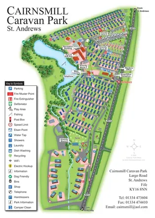
Portrait park map combining numbered caravan rows, touring and tent areas with a reservoir-side recreation hub.
Features may come from the sample artwork, its key or published park information. Approximate numbers describe the drawing and may cover only part of a park. They are intended to help you compare map examples. Current facilities and booking information should be checked with the park.
LET’S MAP YOUR PARK
For a map quotation, find your park and draw a rough boundary around it. The area you select helps us work out the design time and price.
Draw your park for a quote ↗Or talk to our map designers
01751 473136