
Central lake
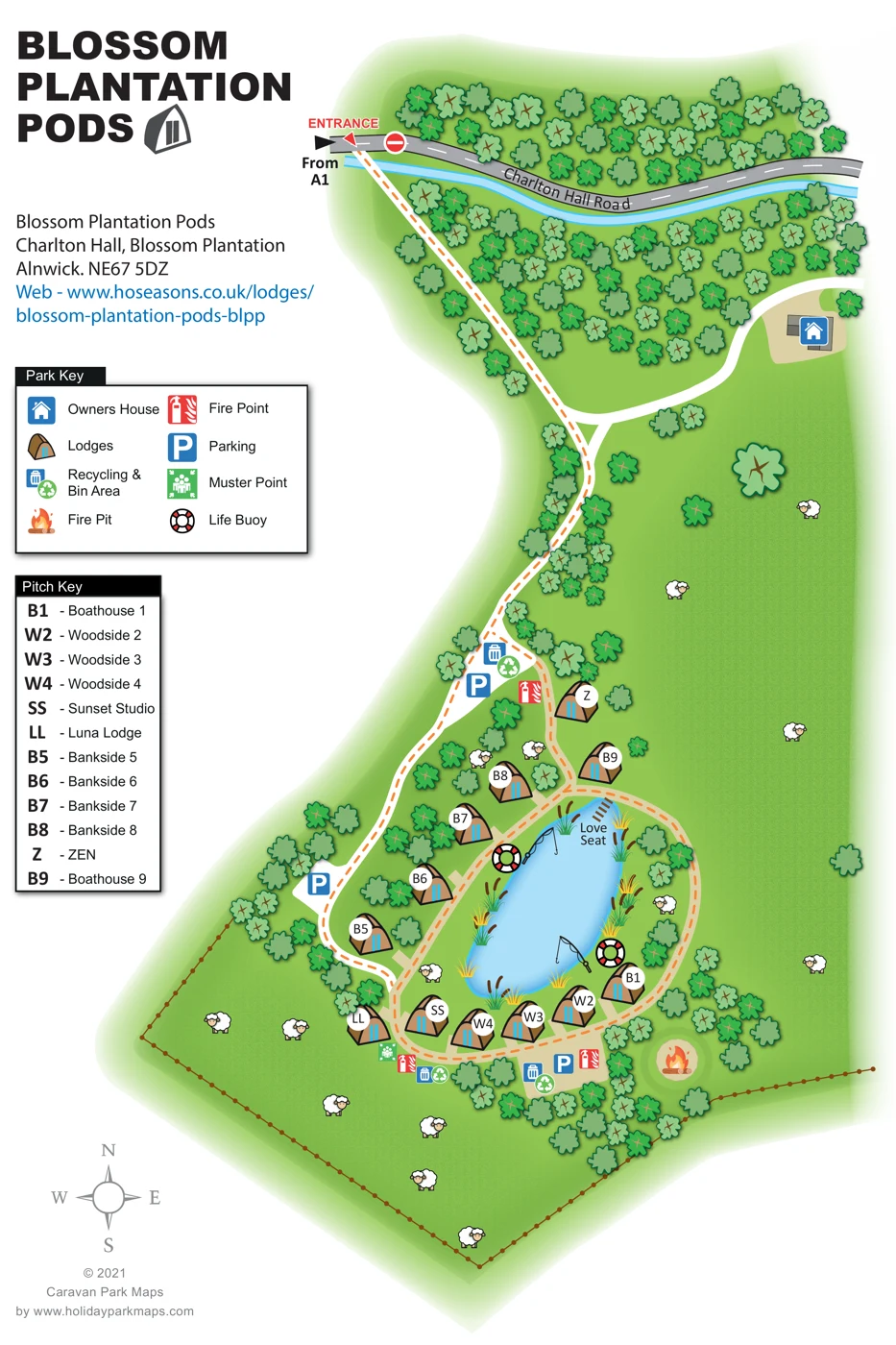
An elongated lake forms the centre of the accommodation area, with illustrated reeds and rushes along its margins.
ILLUSTRATED PARK MAP · P411
Blossom Plantation Pods, Charlton Hall, Blossom Plantation, Alnwick · United Kingdom
 Enlarge the map ↗
A SENSE OF THE PLACE
Blossom Plantation is based at Charlton Hall, Blossom Plantation, Alnwick. The Tempus restaurant and Charlton Hall are a short walk away. Accommodation styles include treehouse cabins, boathouse lodges and lakeside huts; the operator lists eight types.
Each unit has a private deck and hot tub. The site offers lakeside glamping on a working sheep farm on Charlton Hall Estate.
LOOK CLOSER
An elongated lake forms the centre of the accommodation area, with illustrated reeds and rushes along its margins.
Dense tree clusters line the arrival route and frame the lakeside accommodation.
Open green areas with sheep illustrations surround the lodge cluster; the operator identifies the setting as a working sheep farm.
Fishing-rod graphics appear beside the lake as part of the illustration; they do not establish fishing access or permissions.
A small collection of illustrated pods or lodges is arranged around the lake, using short codes linked to the accommodation key.
The Pitch Key names Boathouse, Woodside and Bankside accommodation, alongside Sunset Studio, Luna Lodge and ZEN.
The entrance is labelled on Charlton Hall Road, with an approach annotation reading ‘From A1’.
A white route descends through woodland from the entrance and branches towards the owners’ house and accommodation area.
A small collection of illustrated pods or lodges is arranged around the lake, using short codes linked to the accommodation key.
The Pitch Key names Boathouse, Woodside and Bankside accommodation, alongside Sunset Studio, Luna Lodge and ZEN.
An elongated lake forms the centre of the accommodation area, with illustrated reeds and rushes along its margins.
Dense tree clusters line the arrival route and frame the lakeside accommodation.
Open green areas with sheep illustrations surround the lodge cluster; the operator identifies the setting as a working sheep farm.
The entrance is labelled on Charlton Hall Road, with an approach annotation reading ‘From A1’.
A white route descends through woodland from the entrance and branches towards the owners’ house and accommodation area.
An orange-dashed route continues around the lake and connects the accommodation; its exact route classification is not stated.
Blue parking symbols mark several locations along the approach and beside the accommodation cluster.
The owners’ house is marked on a separate branch of the approach, north-east of the accommodation.
Grouped bin and recycling symbols appear near the northern service area and along the southern side of the lodges.
Red fire-point symbols are positioned at several locations around the accommodation area.
A green muster-point symbol is shown near the south-western accommodation.
Lifebuoy symbols are positioned on opposite sides of the lake.
A flame illustration in a circular clearing marks a fire pit south-east of the lake.
A seat near the northern end of the lake is explicitly labelled ‘Love Seat’.
Fishing-rod graphics appear beside the lake as part of the illustration; they do not establish fishing access or permissions.
The operator describes accommodation styles including treehouse cabins, boathouse lodges and lakeside huts.
The operator states that each accommodation unit has a private deck and hot tub; these are not individually drawn on the map.
Charlton Hall and The Tempus restaurant are described as a short walk away, but are not located on this plan.
READING THE MAP
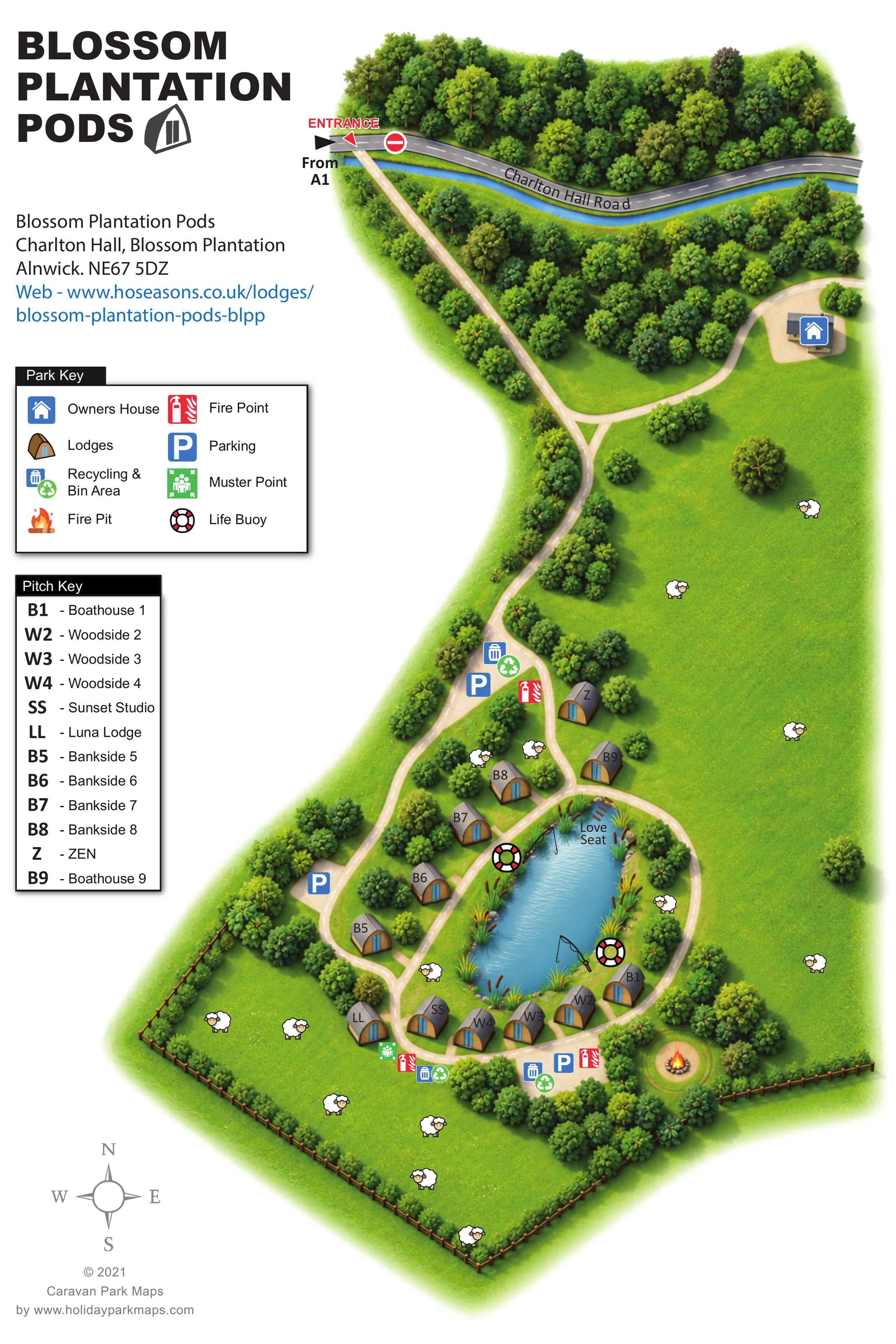
Blossom Plantation Pods is shown as a small lakeside retreat reached through woodland from Charlton Hall Road, near Alnwick. This illustrated map follows that journey from the entrance at the top of the page to a collection of named pods and lodges gathered around a long blue lake. The surrounding trees, open pasture and sheep give the plan a recognisable farm-estate character rather than the appearance of a conventional caravan park.
The map combines an expressive landscape illustration with practical guest information. Short accommodation labels connect to a separate naming key, while parking, recycling, fire points and lakeside safety equipment are highlighted with clear symbols. A waterside love seat and a separate fire pit add distinctive points of interest. The owners’ house is also located, apart from the main accommodation cluster.
For a designer’s gallery, this is a useful example of a portrait-format map for a compact glamping destination with an extended approach. It shows how named accommodation, a central landscape feature and a simple route network can be brought together without filling the artwork with long labels.
The plan begins at Charlton Hall Road across the top of the page, where a red entrance label and a ‘From A1’ annotation identify the arrival point. A long white route, overlaid with orange dashes, descends through woodland before reaching the guest accommodation. A branch leads east to the owners’ house, which is shown separately in open ground. Parking and recycling symbols mark a service cluster near the northern end of the lodge area, with further parking beside the western approach and along the southern edge.
The main accommodation group wraps around an elongated blue lake. Small brown, curved-roof lodge illustrations carry white circular labels, with a separate Pitch Key translating the short codes into names. These include Boathouse, Woodside and Bankside units, together with Sunset Studio, Luna Lodge and ZEN. The orange-dashed route continues around the lake, linking the scattered units into a readable circuit rather than a regimented row of pitches.
Reeds and rushes soften the lake margins, and fishing-rod illustrations add waterside character. A labelled love seat sits near the northern end of the water. Lifebuoy symbols appear at the lakeside, while fire points, recycling and bin areas are grouped at practical locations around the accommodation. A green muster-point symbol is positioned near the south-western lodges. A separate fire pit is illustrated in a circular clearing to the south-east.
Dense clusters of stylised trees frame the arrival route and accommodation, opening into sheep-dotted pasture around the lower and right-hand sides. A brown post-and-line boundary encloses part of the southern ground. The left-hand column contains the bold park branding, address, website, two boxed keys and a compass, leaving the illustrated landscape as the dominant element.
 Enlarge this map ↗
KEEP EXPLORING
Chosen for shared landscapes, accommodation or facilities.
 Explore the map ↗
United Kingdom
Woodland park map with mixed pitches, bell tents, lodges and a fishing lake.
 Explore the map ↗
United Kingdom
Illustrated lakeside park plan with numbered holiday units, leisure buildings and a looping Woodland Walk.
 Explore the map ↗
United Kingdom
Colour-coded accommodation, lakeside facilities and woodland routes at Burton Constable Holiday Park & Arboretum.
Features may come from the sample artwork, its key or published park information. Approximate numbers describe the drawing and may cover only part of a park. They are intended to help you compare map examples. Current facilities and booking information should be checked with the park.
TAKE A CLOSER LOOK
View the illustrated map in detail or choose a file to download. These are sample maps; contact the park for current visitor information.


LET’S MAP YOUR PARK
For a map quotation, find your park and draw a rough boundary around it. The area you select helps us work out the design time and price.
Draw your park for a quote ↗Or talk to our map designers
01751 473136